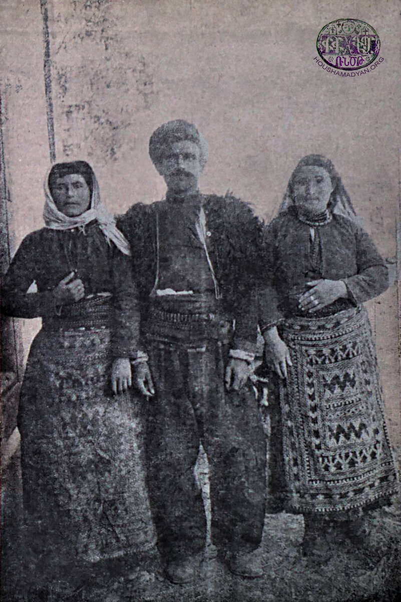
Sassoun - Demography
Population Statistics per Village
Author: Tigran Martirosyan, 25/02/21 (Last modified 25/02/21)

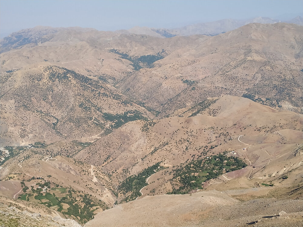
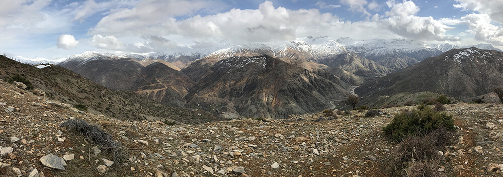
Sassoun, a mountainous region in the southern peripheral zone of the outer margin of the Armenian Highlands, [1] was especially densely populated by Armenians centuries before and throughout the Ottoman period. In 1889, when the Ottoman authorities formed a new province, the vilayet of Bitlis, known among Armenians as Baghesh, the areas traditionally comprising Sassoun were allocated to different sandjaks, or prefectures, within that province. Hence, Sassoun Central, Shatakh, and Hazzo-Khabldjoz formed part of Moush (Muş); Psank and Kharzan of Sgherd (Siirt); Khian, Khoulp, and Talvorik of Gendj (Genç); and Khout-Brnashen and Motkan of Bitlis, a sandjak of the same name as the province.
Given Sassoun’s rough mountainous terrain and dispersed settlements lying within ambiguously demarcated administrative boundaries, data sources used for this study suggested varying numbers of territorial units comprising the region, ranging from five to as many as fifteen. This study will provide data on Armenian populations per village in the following eleven units to which data sources most often referred: [2]
1. Shatakh and Tzovasar,
2. Talvorik,
3. Ishkhandzor,
4. Gavar or Boun Sassoun,
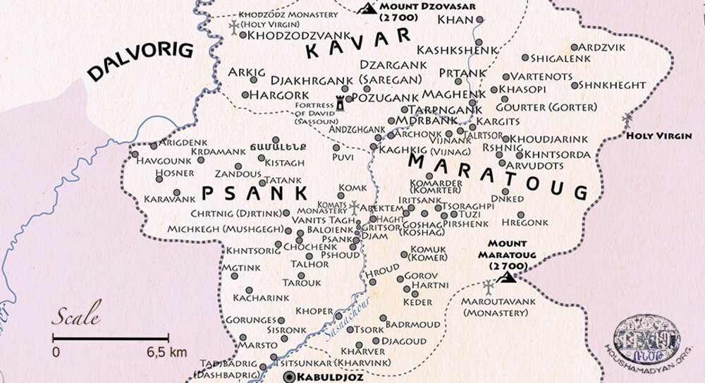
5. Maratuk,
6. Khiank,
7. Khoulp,
8. Khout-Brnashen,
9. Hazzo-Khabldjoz,
10. Psank, and
11. Motkan.
The data are drawn from sources covering a period of 37 years or from 1878 to 1915. These sources, in the order of their publication dates, are as follows:
- Aristakes Tevkants, an Armenian folklorist who journeyed to Sassoun in 1878 (referred as Tevkants); [3]
- Editorial “Sassoun” published in Ardzagank, 1882, 1894 (referred as Ardzagank); [4]
- Bishop Garegin Srvandztiants, 1884 (referred as Srvandztiants); [5]
- Editorial “Sassoun, A Description of the Region, its People, and their Customs and Lifestyle” published in Arax, 1894-1895 (referred as Arax); [6]
- List of Armenian villages destroyed during the 1894 Sassoun massacre published in Moorch, 1895 (referred as Moorch); [7]
- Annex to the Joint Report of the Consular Delegates to the Sassoun Commission, 1895 (referred as Joint Report); [8]
- British Foreign Office’s Confidential Papers, 1895-1897 (referred as FO); [9]
- Armenian Patriarchate of Constantinople census data collected by Gegham Ter-Karapetian, 1902 (referred as Ter-Karapetian); [10]
- Russian General Staff colonel Vladimir Mayewski, 1904 (referred as Mayewski); [11]
- Armenian statistician A-Do, 1912 (referred as A-Do); [12]
- Armenian Patriarchate of Constantinople census, 1913-1914 [13], including figures from supplementary Patriarchate census data available to Kévorkian and Paboudjian, 1992 (referred as Patriarchate); [14]
- Secretary of the Moush Prelacy Nazaret Martirosian, 1916 and 1917 (referred as Martirosian); [15]
- Armenian writer Teodik, 1921 (referred as Teodik); [16]
- Ethnographer Vardan Petoyan, 1954 (referred as Petoyan); [17]
- Armenian intellectual Karo Sassouni, 1957 (referred as Sassouni); [18]
- Testimonies of various genocide survivors in Virabyan, 2012. [19]
Of these, Mayewski supplied data on Khout-Brnashen and Motkan he gathered during a trip to Bitlis in 1899, which were supplemented in 1904 with figures for other areas of Sassoun he had borrowed from Pro Armenia. [20] In Ter-Karapetian’s compilation, most original figures were adjusted apparently at a later time; in this study, the pride of place goes to these adjusted figures. A-Do provided data he had extracted from a 1909 Moush Prelacy bulletin that apparently contained a household-and-population count. Martirosian between 1913 and 1915 updated the data he had earlier supplied to A-Do. The data reported by Teodik, Petoyan and Sassouni pertain to the years preceding the genocide. Survivors’ testimonies refer to the period beginning in April of 1915 and continuing into the following months.
For British Foreign Office alphanumeric codes, starting with the letters “FO,” readers should consult titles and publication dates of the Confidential Papers referenced in Endnote 9. The Annex to the Joint Report of the Consular Delegates to the Sassoun Commission, a team of three Ottoman officials and three delegates from Britain, Russia, and France entrusted with the task of investigating the 1894 Sassoun massacre, is hereafter referred to as Joint Report.
Ottoman sources, such as the government annuals for the state and provinces, called salnamés, official census reports, and government registries of the Armenian populations subjected to forced deportations in 1915, are omitted from this study because they offered no per village population data.

Listed below are villages and village neighborhoods, known as tagher in Armenian or mahalles in Turkish that, according to at least one verifiable source were either entirely or largely populated by Armenians or had a number of Armenian households or inhabitants during the period mentioned above. Their current Turkified names are placed in square brackets. Several larger villages had sub-neighborhoods or hamlets, called tagh gyughakner in Armenian, in addition to or in lieu of neighborhoods; only the ones which have been verified in the data sources are set out in the village lists below.
Also included are formerly Armenian villages that were seized by the Kurds after the influx of Kurdish tribes into Sassoun during the late eighteenth and early nineteenth centuries or whose inhabitants were forced to abandon properties and flee fearing an outbreak of Kurdish violence. Already in the early twentieth century, several of these villages were identified as localities that had been deserted by indigenous Armenian inhabitants. [21]
For larger village groups, such as Gelieguzan or Egutoun (also called Talvorik), sources oftentimes failed to specify whether the population data they supplied pertained to the village group or the principal village of the same name; thus, discrepancies in the number of households and/or inhabitants that are immediately arresting. Readers will notice that the names of a few dozen localities, mostly in Khiank and Khoulp, are marked as “abolished” or “name no longer in use.” The reason is that in 2012, Turkey’s Diyarbekir province, to which parts of these two former Sassoun areas now belong, was transformed into a metropolitan municipality, and all village neighborhoods, called muhtarlıks in Turkish, were turned into urban neighborhoods. Consequently, the recording of names of the sub-neighborhoods near muhtarlıks hass been discontinued. [22] Their abolished names will nevertheless appear in brackets, wherever possible.
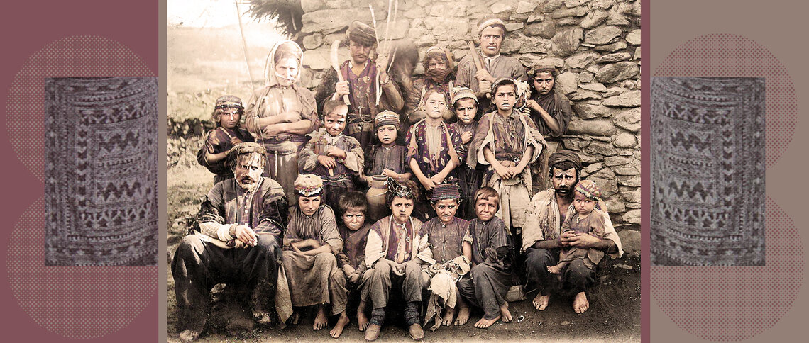
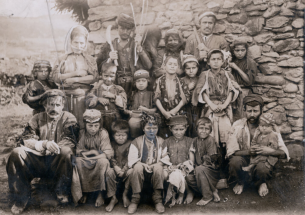
In cases when sources supplied household counts only, readers should use eight as an average number of members per household for the rural areas, as suggested by Bishop Vahan Ter-Minassian (Partizaktsi), a commissioner at the Patriarchate in the 1860s and 1870s. [23] It should be borne in mind, however, that the average household size in Sassoun was almost certainly greater than eight. Alexander Kalantar, the editor-in-chief of the periodical Mshak, reported “ten to twenty or, in some cases, as many as forty,” inhabitants in a household in Sassoun. [24] In the testimony of a genocide survivor from Tahlasev, a village in the southernmost section of the Plain of Moush adjacent to Sassoun, the number of persons living in a house in Sassoun ranged from seven to forty. [25]
In virtually every territorial unit there existed two or more hamlets, typically near larger villages, that bore the name mezra, Arabic for “hamlet.” In many instances, it was not possible to determine to which mezra a source referred. Therefore, with a few exceptions, localities under this name or its variations: mezre, mzre, mazre or mazra, were left out of this study
In cases when verification of the conformity of pre-1915 village names with their present-day names yielded no results, other known names, including ones that had been in use before they were Turkified starting from the 1920s onwards and some Kurdish name variants, are offered, wherever possible. If the relevant spaces after a locality are left blank, it should be understood that the village has been identified as containing a number of Armenian households and/or inhabitants at some point during the period under study, but that the data sources offered no information on its present-day name and/or population size.
Unless otherwise mentioned, all households and/or inhabitants in the village list below were reported by the data sources as being Armenian. In cases when two or more sources supplied similar village population data, only one primary source or, in the absence thereof, a randomly selected secondary source, will be listed, to avoid repetition. In addition to village name variants mentioned below, there were less common colloquial variants, which are omitted from the list.
Shatakh and Tzovasar
Aghbi, Akhpi, Aghbik, Aghbink, Aghpi, Agpi, Aghpig, Aghpik, Aghbek, Yerkuaghbi [Balcılar]
38°34'18.57"N, 41°24'7.89"E
Tevkants: 315 inhabitants, Moorch: 60 households, Arax: 35 households, Ardzagank no. 150: 95 households, FO 881-6654: 80 households, FO 881-6959: 601 inhabitants, FO 424-208: 620 inhabitants, Ter-Karapetian: 815 inhabitants, Mayewski: 60 households, Patriarchate: 548 inhabitants, Martirosian: 1,250 inhabitants, Teodik: 102 households, Petoyan: 835 inhabitants, genocide survivor Martiros Hamazaspyan-Toumasyan: 200 households, genocide survivor Khazo Grigoryan: 140 households.
Aghbi’s neighborhoods:
- Verin tagh
- Nerkin tagh
Aghbi’s sub-neighborhoods:
- Gelarash, Gyalarash, Kalarash, Kelerash, Kealarash, Kelrash, Kelaresh, Kyalarash [other known name Geliyeres]: 38°33'40.11"N, 41°23'42.96"E - Moorch: 4 households, FO 881-6654: 20 households, Patriarchate: 87 inhabitants, Teodik: 16 households, Petoyan: 11 households.
- Tkhik, Tekhik, Trkhik [Soğukpınar]: 38°33'16.67"N, 41°24'33.20"E - Moorch: 7 households, Tevkants: 70 inhabitants, FO 881-6654: 10 households, Petoyan: 4 households.
- Khadan, Khatan, Khtan, Khrtan, Khidan, Khaghan [possibly Konak, other known name Hican]: 38°34'37.38"N, 41°21'44.32"E - Moorch: 20 households, Arax: 100 households, FO 881-6823: 14 households, genocide survivor Khazo Grigoryan: 15 households.
Aliank, Aleank, Aliants, Aliantsik, Alyantsik, Aliantzik, Aliantizik [Arıköy]
38°37'54.55"N, 41°20'13.14"E
Moorch: 25 households, Arax: 50 households, Ardzagank no. 150: 35 households, FO 881-6654: 400 households together with Gelieguzan, FO 424-208: 1,444 inhabitants together with Gelieguzan, Ter-Karapetian: 458 inhabitants, A-Do: 539 inhabitants, Mayewski: 60 households, Patriarchate: 566 inhabitants, Martirosian: 760 inhabitants, Teodik: 65 households, Sassouni: 15 households, genocide survivor Martiros Hamazaspyan-Toumasyan: 75 households, genocide survivor Khazo Grigoryan: 30 households.
Aliank’s sub-neighborhoods:
- Gyaresar, Gerhasar, Kerehisar, Kergosar, Kerehesar, Kerhesar: Moorch: 10 households, Ter-Karapetian: 32 inhabitants.
- Baloyi arter, Ployarter, Bloyi gegh: Moorch: 10 households.
- Bonke hovit, Ponke, Boun gegh: Moorch: 20 households.
- Aliantsots geli, Aliantsots gyali
Geghashen [Gökçeli]
38°37'11.59"N, 41°24'42.70"E
Tevkants: 151 inhabitants, Arax: 20 households, FO 881-6654։ 40 households, FO 424-208: 239 inhabitants, Ter-Karapetian: 285 inhabitants, Mayewski: 15 households, Patriarchate: 392 inhabitants, Martirosian: 330 inhabitants, Teodik: 44 households, Petoyan: 289 inhabitants, genocide survivor Martiros Hamazaspyan-Toumasyan: 40 households, genocide survivor Khazo Grigoryan: 40 households.
Geliegenman, Geliekenman, Gelieganman, Gyalegyanman, Gyalegranman, Gelieganiman, Geliegenma, Kelikeneman, Keliekenman, Keliekeneman, Kelei-Kaneman, Klenkiman, Kalekgenma, Kalek-Genma, Kaleikneman, Kalekgenman, Tsornadzor [Buğdaylı]
38°40'33.15"N, 41°18'37.30"E
Moorch: 20 households, Joint Report: 6-7 households, FO 881-6654: 25 households, FO 424-208: 204 inhabitants together with Geliemsour, Ter-Karapetian: 13 households, Mayewski: 15 households, Patriarchate: 133 inhabitants, Martirosian: 210 inhabitants, Teodik: 12 households, Petoyan: 10 households, genocide survivor Martiros Hamazaspyan-Toumasyan: 35 households.
Gelieguzan, Gale kuzan, Gelei-Kuzan, Gelie-Kuzan, Galei Gozan, Galiegozan, Geli, Geligozan, Geliguzan, Geliegyuzan, Geliekuzan, Gileguzan, Geliegozan, Kelei-Kuzan, Kelei-Kyuzan, Keliekuzan, Kelikuzan, Kellikuzan, Kleikuzan, Gugh Keleikyuzan, Enkouzadzor [Cevizlidere]
38°35'20.15"N, 41°20'45.91"E
Moorch: 80 households, FO 881-6654: 400 households together with Aliank, FO 881-6959: 1,320 inhabitants for unspecified 7 neighborhoods; FO 424-208: 1,444 inhabitants together with Aliank, Ter-Karapetian: 1,500 inhabitants, Mayewski 120 households, A-Do: 1,030 inhabitants, Patriarchate: 1,025 inhabitants, Martirosian: 1,320 inhabitants, Teodik: 300 households, Petoyan: 3,500 inhabitants, genocide survivor Martiros Hamazaspyan-Toumasyan: 700 households, genocide survivor Khazo Grigoryan: 300 households, genocide survivor Toros Simonyan: 2,035 inhabitants.
Gelieguzan’s neighborhoods:
- Yekeghecvo tagh, Yekeghecutagh, Boun gyugh, Boun gegh, Gyugh, Geli, Nerkin Gelin: Ter-Karapetian: 402 inhabitants, A-Do։ 20 households, Sassouni: 40 households, genocide survivor Khazo Grigoryan: 15 households.
- Khardzn gomer, Harsn-Gomer, Khardzngom, Khardzngomer: A-Do։ 2 households, Sassouni: 3 households.
- Daghvnik, Daghvrnik, Daghbrnik, Taghvrni, Taverni, Taghvenik: A-Do։ 10 households.
- Gharibdjan, Gharipchan, Kharibshan, Kharipshan, Kharbshan: Moorch: 13 households, Ter-Karapetian: 91 inhabitants, A-Do։ 12 households, Sassouni: 15 households.
- Mkhitar: Moorch: 15 households, Ter-Karapetian: 83 inhabitants, A-Do։ 7 households, Martirosian: 250 inhabitants, Sassouni: 10 households.
- Mazresa, Mazresan, Mzresan, Mzersan: A-Do։ 2 households, Sassouni: 3 households.
- Hosel, Hoslner, Hoselner, Hosilner: A-Do։ 5 households, Sassouni: 7 households.
- Hyuseintsik, Housentsik: Moorch: 30 households, Ter-Karapetian: 193 inhabitants, A-Do։ 15 households, Sassouni: 20 households.
- Khasoyimzren, Khasoi Mzren, Khasoyi mzre, Khazoyi Mzre, Mzre Khaso: A-Do։ 8 households, Sassouni: 12 households.
- Dhol, Dehol, Dholner, Taholner, Daholner, Deholner, Doholnin: Ter-Karapetian: 85 inhabitants, A-Do։ 12 households, Sassouni: 17 households.
- Kavrdik, Kaverdik, Kavrti, Kavertik, Kavrtik, Gabrdik: A-Do։ 1 household.
- Reshik, Rashek, Rashekner, Rashokner, Resheknin, Rshknin: A-Do։ 10 households, Sassouni: 15 households.
- Ambar, Ambarner, Ambarnin, Ambrnin [other known name Ambar]: A-Do։ 5 households, Sassouni: 8 households.
- Khoshok, Khoshokner [other known name Hoşik]: Moorch: 12 households, Ter-Karapetian: 58 inhabitants, A-Do։ 11 households, Sassouni: 15 households.
- Merker, Merger, Merkir, Merki, Merchi [other known names Mergan, Mergani]: Moorch: 8 households, Ter-Karapetian: 78 inhabitants, A-Do։ 13 households, Sassouni: 17 households.
- Harmoyi gomer, Harmoyigom, Harmo gomer, Hrmoyi gom, Harmoi gom, Gyalesan, Geliesan, Klisan: Moorch: 8 households, Ter-Karapetian: 87 inhabitants.
- Pali gomer, Paligom, Palo gomer, Palo gomanin, Pali gomanin
- Alochak, Alouchak, Alochik: Moorch: 7 households.
Gelieguzan’s sub-neighborhoods:
- Gerik, Gyarek: A-Do։ 1 household.
- Midjelner, Medjelner, Mdjelin, Medjlnin, Medjelnin: Martirosian: 130 inhabitants․
- Spitak kar [other known names Kyavrespi, Kavraspi, Kevirê spî]
- Lisek [other known name Liçik]
- Khadjek [other known name Kıjık]
- Veri Geli, Veri Gelin, Veri Gyalin
- Radjalner, Radjalnin
- Avia khani, Aviakhani
- Bayarner, Bayarnin
- Majdek
- Mrdaour, Mirdaour
- Shirnik
Geliemsour, Galiemsour, Gelimnsour, Gelimansur, Galei-Msour, Gelie msour, Gelei-Msour, Geliegemsour, Gyalemsour, Keliemsour, Kelei-Msour, Keleimesour, Kelie msour, Sheliemnsour, Nerkin Geli, Msradzor [other known name Gelimansur]
Approximate location: 38°38'22.63"N, 41°17'2.76"E
Srvandztiants: 21 households, FO 881-6654: 24 households, FO 881-6695: 30 households, FO 424-208: 204 inhabitants together with Geliegenman, Ter-Karapetian: 110 inhabitants, Mayewski: 20 households, Patriarchate: 198 inhabitants, Martirosian: 280 inhabitants, Petoyan: 40 households, genocide survivor Martiros Hamazaspyan-Toumasyan: 50 households.
Germar, Germav, Garmav, Avgerm, Avagarm, Avgarm, Avekearm, Karmar, Karmav, Kearmav, Djermouk, Djermadjour [Ilıca]
38°35'25.61"N, 41°29'23.44"E
Tevkants: 19 inhabitants, Arax։ 40 households, FO 881-6823: 25 households, FO 881-6654: 50 households, FO 424-208: 331 inhabitants, Ter-Karapetian: 210 inhabitants, Mayewski: 30 households, Patriarchate: 395 inhabitants, Martirosian: 580 inhabitants, Teodik: 46 households, Petoyan: 460 inhabitants, genocide survivor Martiros Hamazaspyan-Toumasyan: 55 households, genocide survivor Khazo Grigoryan: 40 households.
Hetink, Yetink, Hetin, Hertink, Hiten, Hitenk, Hitink, Hitenk, Heteng, Hetenk, Tetuik, Tetounk, Gerink [İnardı]
38°31'47.27"N, 41°23'31.59"E
Tevkants: 150 inhabitants, Arax։ 50 households, Joint Report: 40 households, FO 881-6823 30: households, FO 881-6654: 100 households, FO 881-6959: 328 inhabitants, FO 424-208: 380 inhabitants, Ter-Karapetian: 485 inhabitants, Mayewski: 35 households, Patriarchate: 429 inhabitants, Martirosian: 920 inhabitants, Teodik: 60 households, Petoyan: 456 inhabitants, genocide survivor Rostom Kameyan: 800 inhabitants, genocide survivor Martiros Hamazaspyan-Toumasyan: 100 households, genocide survivor Khazo Grigoryan: 100 households.
Hetink’sneighborhoods:
- Verin tagh
- Nerkin tagh
- Nrna, Nrnan, Nerna, Nrnencik, Nrnots, Nrna Verin [Danacık]: 38°33'17.62"N, 41°24'32.26"E
- Nrna, Nrna Nerkin [Kırık]: 38°32'59.23"N, 41°23'52.66"E - Moorch: 70 households apparently for both upper and lower localities together with Verin tagh and Nerkin tagh.
Hetink’s sub-neighborhoods:
- Avaraks, Avaras: 38°31'45.91"N, 41°22'32.24"E
- Lerngomer
- Chorout
- Kanach ktor, Kanach gedor
- Kokvtik, Kozvtik, Gogevtik, Kokvetik, Koglovit
- Hagrvank, Hagervouk, Hakervounk
Kop, Gob, Kob [İncesu]
38°35'46.79"N, 41°28'14.43"E
Tevkants: 245 inhabitants, Arax։ 30 households, FO 881-6823: 28 households, FO 881-6654: 50 households, FO 424-208: 416 inhabitants together with Zeynektsik, Ter-Karapetian: 425 inhabitants, Mayewski: 45 households, Patriarchate: 429 inhabitants, Martirosian: 725 inhabitants together with Zeynektsik, Teodik: 52 households, Petoyan: 196 inhabitants, genocide survivor Martiros Hamazaspyan-Toumasyan: 75 households, genocide survivor Khazo Grigoryan: 60 households.
Semal, Sema gyugh, Semol, Sima, Simal [Üçevler]
38°38'25.05"N, 41°22'33.41"E
Moorch: 50 households, Arax: 60 households, Ardzagank no. 150: 70 households, FO 881-6695: 50-60 households, FO 881-6654: 60 households, FO 881-6959: 643 inhabitants, FO 424-208: 711 inhabitants together with Dashtak, Ter-Karapetian: 1,116 inhabitants, A-Do: 798 inhabitants, Mayewski: 65 households, Patriarchate: 889 inhabitants, Martirosian: 1,380 inhabitants, Teodik: 120 households, Petoyan: 602 inhabitants, genocide survivor Martiros Hamazaspyan-Toumasyan: 100 households, genocide survivor Khazo Grigoryan: 80 households.
Semal’sneighborhoods:
- Dashtok Verin, Dashtak: Moorch: 12 households.
- Dashtok Nerkin, Dashtak: Moorch: 8 households, Ter-Karapetian: 161 inhabitants apparently for both upper and lower localities.
- Blourik, Plourik, Blour
- Bsharatkan, Bsharetkan
Shenik, Shenek, Shenig, Shnek [Alaniçi]
38°39'28.82"N, 41°20'0.05"E
Moorch: 40 households, Arax: 80 households, A-Do: 654 inhabitants, FO 881-6654: 110 households, FO 881-6959: 540 inhabitants, FO 424-208: 557 inhabitants, Ter-Karapetian: 817 inhabitants, Mayewski: 55 households, Patriarchate: 690 inhabitants, Martirosian: 810 inhabitants, Teodik: 80 households, Petoyan: 635 inhabitants, genocide survivor Martiros Hamazaspyan-Toumasyan: 105 households, genocide survivor Khazo Grigoryan: 70 households.
Shenek’s sub-neighborhoods:
- Mzresork, Mzre-Sork, Mzresorp, Mziesorp, Mzbesori, Mzre, Mzrek: Moorch: 15 households.
- Tape, Tabi, Tabe, Dape: Moorch: 10 households.
- Boun Shenik
- Gurchok, Gurchoknin
Shoushnamerk, Shօushmamerk, Shօushnamarg, Shoushiamarg, Shoushnamerg [Ekindüzü]
38°36'38.94"N, 41°24'43.91"E
Tevkants: 133 inhabitants, Arax։ 30 households, Ardzagank no. 151: 32 households, FO 881-6654: 80 households, FO 424-208: 221 inhabitants, Ter-Karapetian: 263 inhabitants, Mayewski: 25 households, Patriarchate: 286 inhabitants, Martirosian: 310 inhabitants, Petoyan: 245 inhabitants, genocide survivor Stepan Harutyunyan: 350 inhabitants, genocide survivor Martiros Hamazaspyan-Toumasyan: 42 households, genocide survivor Khazo Grigoryan: 35 households.
Tape, Tap, Chelhavroun [other known name Çîlhâvruni]
Approximate location: 38°35'15.80"N, 41°30'37.66"E
Tapek, Tapeg, Tapek, Tapik, Tapka, Tapk, Dapik [Ağıllı]
38°36'15.78"N, 41°26'24.38"E
Tevkants: 144 inhabitants, Arax։ 26 households, FO 881-6823: 30 households, FO 881-6654: 20 households, FO 424-208: 205 inhabitants, Ter-Karapetian: 195 inhabitants, Mayewski: 17 households, Patriarchate: 244 inhabitants, Martirosian: 290 inhabitants, Teodik: 34 households, Petoyan: 200 inhabitants, Sassouni: 240 inhabitants, genocide survivor Martiros Hamazaspyan-Toumasyan: 30 households, genocide survivor Khazo Grigoryan: 20 households.
Yeritsank, Iritsank, Iritzank, Iritsounk, Irtsank [other known name İrsank]
38°36'12.17"N, 41°26'52.64"E
Tevkants: 140 inhabitants, Arax։ 15 households, FO 881-6823: 12 households, FO 424-208: 106 inhabitants, Ter-Karapetian: 134 inhabitants, Mayewski: 10 households, Patriarchate: 134 inhabitants, Martirosian: 180 inhabitants, Teodik: 17 households, Petoyan: 95 inhabitants, genocide survivor Martiros Hamazaspyan-Toumasyan: 30 households, genocide survivor Khazo Grigoryan: 15 households.
Zeynektsik, Zeynek, Zaynektsik, Zainekner, Zayneknin [Ekinci]
38°36'48.68"N, 41°28'54.55"E
FO 424-208: 416 inhabitants together with Kop, Martirosian: 725 inhabitants together with Kop, Petoyan: 210 inhabitants.

Talvorik
Artkhonk, Artkho, Artkhou, Ardkhou, Hartkho, Hertkho, Artkhounk, Ardkhounk, Artonk, Artevenk [Hertehu]
38°27'1.66"N, 41°18'16.00"E
Tevkants: 48 inhabitants, Arax: 25 households, Joint Report: 35 households, FO 881-6654: 12 households, FO 424-208: 65 inhabitants together with Korakhou, Ter-Karapetian: 131 inhabitants, Mayewski: 15 households, A-Do։ 30 households, Teodik: 10 households for both Artkhonk and Korakhou, Petoyan: 9 households for both Artkhonk and Korakhou, genocide survivor Martiros Hamazaspyan-Toumasyan: 20 households.
Artkhonk’s neighborhood:
- Korakhou, Korakho, Korekhou, Khorakhou[Elmapınar]: 38°27'20.60"N, 41°18'18.60"E - Moorch: 40 households, FO 881-6654: 12 households, Ter-Karapetian: 103 inhabitants, FO 424-208: 65 inhabitants together with Artkhonk, Teodik: 10 households for both Korakhou and Artkhonk, genocide survivor Martiros Hamazaspyan-Toumasyan: 30 households.
Brdank [other known name Pertank]
Approximate location: 38°29'4.25"N, 41°22'32.35"E
Ardzagank no. 147: 10 households, Patriarchate: 26 inhabitants, Petoyan: 5 households․
Dvalenk, Dvalin, Dvalink, Divalink, Dualink, Tevalink, Tvalenk, Tvalink, Tvaling, Tualenk, Tualink [Tufalink]
38°27'53.25"N, 41°19'35.47"E
Srvandztiants: 10 households, Arax։ 35 households, Joint Report: 40 households, FO 881-6823: 22 households, FO 881-6654: 30 households, FO 881-6959: 89 inhabitants, FO 424-208: 65 inhabitants, Ter-Karapetian: 191 inhabitants, Mayewski: 15 households, A-Do։ 13 households, Patriarchate: 85 inhabitants, Martirosian: 250 inhabitants, Teodik: 11 households, genocide survivor Martiros Hamazaspyan-Toumasyan: 40 households․
Dzorer, Zorer, Talvoriki Dzorer, Tzorir, Tsorer [other known names possibly Sorir, Navale]
38°30'40.35"N, 41°21'7.66"E
Moorch: 15 households, Arax: 25 households, Ter-Karapetian: 89 inhabitants, FO 424-208: 22 inhabitants, A-Do։ 3 households, Patriarchate: 20 inhabitants, Martirosian: 250 inhabitants, genocide survivor Khazo Grigoryan: 15 households․
Egutoun, Boun Talvorik, Eghutoun, Egetoun, Ekudoun, Egu-Toun, Egou tun, Egetoun, Aygetoun, Aygutoun, Talvorik, Talouorik, Dalvorik, Talhorik, Talor, Talori, Talvori, Tolori, Heki [Gidonk or Ekedoun]
38°28'50.13"N, 41°19'36.68"E
Moorch: 60 households, Arax։ 30 households, FO 881-6654: 60 households for Egutoun and Talvorik, FO 881-6695: 300-400 households for Talvorik, FO 881-6654: 3,000 inhabitants for Talvorik, FO 424-208: 152 inhabitants, Ter-Karapetian: 586 inhabitants, Mayewski: 25 households, A-Do։ 35 households, Patriarchate: 228 inhabitants, Martirosian: 450 inhabitants, Teodik: 20 households, genocide survivor Martiros Hamazaspyan-Toumasyan: 80 households, genocide survivor Khazo Grigoryan: 500 households for unspecified 7 neighborhoods․
Egutoun’s neighborhoods:
- Eratz
- Kotratz
Egutoun’s sub-neighborhoods:
- Merger, Merkir [other known name Mirgâh]: 38°30'4.04"N, 41°19'26.55"E - Joint Report: 25 households.
- Verin gyugh, Veringegh, Verin gegh: Srvandztiants: 12 households.
- Ktank [other known names Gidank, Gidonk]
Erots [other known name Ekras]
38°31'6.87"N, 41°19'36.01"E
Hagmank, Hakmank, Khakmank, Hagmag, Hekmank, Houmank, Hagmag [other known names Hakmak, Hakmank]
38°28'28.05"N, 41°19'19.24"E
Srvandztiants: 15 households, Arax։ 40 households, FO 881-6823: 20 households, FO 881-6959: 63 inhabitants, FO 424-208: 56 inhabitants, Ter-Karapetian: 82 inhabitants, Mayewski: 10 households, Patriarchate: 97 inhabitants, Martirosian: 365 inhabitants, genocide survivor Martiros Hamazaspyan-Toumasyan: 60 households, genocide survivor Khazo Grigoryan: 50 households․
Hartk, Hartik, Hartuk, Hardk, Khartk, Khardk [other known name Hartik]
38°29'9.21"N, 41°21'30.12"E
Srvandztiants: 5 households, Arax: 60 households, Joint Report: 45 households, FO 881-6823: 21 households, FO 881-6959: 10 households, FO 424-208: 118 inhabitants together with Hosnout, Mayewski: 10 households, A-Do։ 11 households, Patriarchate: 71 inhabitants, Teodik: 20 households together with Hosnout, genocide survivor Martiros Hamazaspyan-Toumasyan: 50 households.
Hloghink, Hloghenk, Haloghenk, Heloghink, Halodenk, Helohink, Hlohink, Holornik, Hloshenk [other known name Helurink]
38°29'21.36"N, 41°18'50.62"E
Srvandztiants: 5 households, Moorch: 50 households, FO 881-6823: 30 households, FO 881-6959: 167 inhabitants, FO 424-208: 148 inhabitants, Ter-Karapetian: 163 inhabitants, Mayewski: 25 households, A-Do։ 40 households, Patriarchate: 260 inhabitants, Martirosian: 350 inhabitants, genocide survivor Martiros Hamazaspyan-Toumasyan: 70 households, genocide survivor Khazo Grigoryan: 20 households․
Hosnout, Khosnout, Khosnud, Dzkngol [other known name Hosnut]
38°28'35.93"N, 41°21'20.35"E
Srvandztiants: 5 households, FO 881-6823: 15 households, FO 424-208: 118 inhabitants together with Hartk, Mayewski: 4 households, Ter-Karapetian: 6 households, Patriarchate: 39 inhabitants, Teodik: 20 households together with Hartk, Petoyan: 9 households, Sassouni: 8 households, genocide survivor Martiros Hamazaspyan-Toumasyan: 20 households.
Khlhovit, Khlhovik, Khelhovit, Khelovik, Khelovit, Kholovik, Khlovit, Khelhovik [possibly Tatlıca]
38°27'34.44"N, 41°20'2.85"E
Srvandztiants: 10 households, Arax։ 17 households, Joint Report: 40 households, FO 881-6823: 16 households, FO 881-6959: 69 inhabitants, FO 424-208: 80 inhabitants together with Hosner and Karavank, Ter-Karapetian: 63 inhabitants, Mayewski: 8 households, Patriarchate: 65 inhabitants, Martirosian: 170 inhabitants, Teodik: 15 households, Petoyan: 9 households.
Ktotni, Ktorni, Gidorni, Gidornik [Kaşyayla]
38°26'8.44"N, 41°17'29.23"E
Mezre, Mezren [other known name possibly Kaleşik]
Approximate location: 38°27'31.78"N, 41°17'20.26"E
Srvandztiants: 15 households, FO 881-6823: 12 households, FO 424-208: 100 inhabitants, Ter-Karapetian: 58 inhabitants, Patriarchate: 97 inhabitants, Martirosian: 95 inhabitants, Petoyan: 20 households.
Pourkh, Porg, Porkh [possibly Purg, other known name Purh]
38°28'8.73"N, 41°20'6.56"E
Srvandztiants: 7 households, Arax։ 25 households, Joint Report: 50 households, FO 881-6823: 20 households, FO 881-6959: 83 inhabitants, FO 424-208: 71 inhabitants, Ter-Karapetian: 172 inhabitants, Mayewski: 15 households, A-Do։ 16 households, Patriarchate: 105 inhabitants, Martirosian: 280 inhabitants, Petoyan: 17 households, genocide survivor Martiros Hamazaspyan-Toumasyan: 50 households․
Spghank, Espghank, Sbaghank, Sepghank, Spagank, Spakan, Spahank, Spaghank, Spghank, Sbghank, Saghank [Konak]
38°30'7.28"N, 41°21'39.70"E
Joint Report: 50 households, FO 881-6823: 16 households, FO 881-6654: 45 households, FO 881-6959: 198 inhabitants, FO 424-208: 70 inhabitants, Ter-Karapetian: 381 inhabitants, Mayewski: 25 households, A-Do։ 11 households, Patriarchate: 72 inhabitants, Teodik: 35 households together with Eghgart, genocide survivor Martiros Hamazaspyan-Toumasyan: 40 households, genocide survivor Khazo Grigoryan: 30 households․
Yeghgard, Yeghgart, Yeghgarn, Yeghkat, Yeghkart, Yeghkart, Eghgard, Eghkard, Yezgard, Yeghkhgard [Ergat]
38°31'7.87"N, 41°21'20.52"E
Arax: 15 households, Joint Report: 30 households, FO 881-6823: 20 households, FO 881-6654: 25 households, FO 424-208: 60 inhabitants, Ter-Karapetian: 126 inhabitants, Mayewski: 12 households, A-Do։ 10 households, Patriarchate: 65 inhabitants, Martirosian: 280 inhabitants, Teodik: 35 households together with Spghank, genocide survivor Martiros Hamazaspyan-Toumasyan: 30 households, genocide survivor Khazo Grigoryan: 15 households.
Ishkhandzor
Artkounk, Artkhonk, Artgounk, Artkonk, Artonk, Ardigounk [other known name Ardingök]
38°30'2.68"N, 41°11'36.37"E
Srvandztiants: 20 households, Moorch: 40 households, Arax։ 50 households, Ardzagank no. 151: 28 households, FO 881-6959: 324 inhabitants, FO 424-208: 220 inhabitants, Ter-Karapetian: 209 inhabitants, Mayewski: 30 households, Patriarchate: 368 inhabitants, Martirosian: 260 inhabitants, Petoyan: 70 households, genocide survivor Harutyun Sargisyan: 300-380 inhabitants.
Artkounk’s neighborhoods:
- Dzorer: Approximate location: 38°29'47.52"N, 41°12'21.90"E
- Koup, Goub [other known name Küp]: Approximate location: 38°29'59.04"N, 41°11'36.87"E
- Miranger, Mirangin, Mirandir [other known name Mirangir]: Approximate location: 38°28'37.21"N, 41°11'1.67"E
- Kpovit, Goubovit [other known name Kipovit]: Approximate location: 38°28'15.11"N, 41°11'44.90"E
- Daghbener, Daghbernir [other known name Dağbinir]
- Tzmakdzor [other known name Simaksur]
- Heghin kpag, Heghinkpag [other known name possibly Hiltapa]
- Midjin tagh, Boun Artkounk
Enkouznak, Enkouzak [other known name Güznak, abolished]
38°31'59.82"N, 41°12'0.11"E
Srvandztiants: 60 households, Joint Report: 20 households, FO 881-6654: 300 inhabitants, FO 881-6959: 291 inhabitants, FO 424-208: 200 inhabitants, Ter-Karapetian: 240 inhabitants, A-Do։ 50 households, Mayewski: 40 households, Patriarchate: 324 inhabitants, Martirosian: 400 inhabitants, Petoyan: 35 households, genocide survivor Hovhannes Mkrtchyan: 580 inhabitants.
Heghin, Yeghin, Yeghi,Khegin [Yuvacık]
38°28'59.98"N, 41° 8'20.94"E
Srvandztiants: 76 households, Arax։ 60 households, FO 881-6654: 45 households, FO 424-208: 120 inhabitants, Ter-Karapetian: 180 inhabitants, Mayewski: 15 households, A-Do։ 20 households, Patriarchate: 416 inhabitants, Martirosian: 540 inhabitants, Petoyan: 70 households.
Ishkhanadzor, Ishkhandzor, Ishkhndzor, Ishkhentsor, Ishkhanour, Ishkhendzor, Ishkhnkor, Ishkintzor [Akçasır]
Approximate location: 38°31'29.93"N, 41°14'47.99"E
Srvandztiants: 70 households, Arax։ 80 households, Ardzagank no. 151: 70 households, Joint Report: 40 households, FO 881-6654: 480 inhabitants, FO 881-6959: 454 inhabitants, FO 424-208: 350 inhabitants, Ter-Karapetian: 218 inhabitants, Mayewski։ 50 households, A-Do։ 100 households, Patriarchate: 495 inhabitants, Martirosian: 1,320 inhabitants, Petoyan: 90 households, genocide survivor Martiros Hamazaspyan-Toumasyan: 100 households, genocide survivor Khazo Grigoryan: 100 households.
Ishkhandzor’s sub-neighborhoods:
- Khuzekou arter, Khzrkou arter: Moorch: 45 households.
- Kalik, Galink, Kalategh
- Norhan, Norhand
- Boun gyugh, Boungegh, Midjin tagh
- Khrvard, Khlvard
Mala Mlke, Mala-Melko [Saltukköy]
38°29'14.98"N, 41°15'43.41"E
Sevid, Sevit, Sevint, Sevik, Sivit, Sefit [Ortaköy, abolished]
38°32'41.45"N, 41°13'11.41"E
Srvandztiants: 12 households, Moorch: 65 households together with Kranos, Arax։ 25 households, Ardzagank no. 151: 20 households, FO 881-6959: 83 inhabitants, FO 424-208: 70 inhabitants, Ter-Karapetian: 52 inhabitants, A-Do։ 6 households, Mayewski: 30 households, Patriarchate: 100 inhabitants, Martirosian: 75 inhabitants, Petoyan: 11 households․
Sevid’s sub-neighborhood:
- Kranos, Kronos: 38°32'33.95"N, 41°13'23.61"E - Moorch: 65 households together with Sevid.
Sivsor, Sev dzor [other known name Zevyasor]
Approximate location: 38°34'37.64"N, 41°11'49.08"E
Vasilnin, Vaslni, Vaselni, Gelievaselni, Gelievaselnin, Gelievasilnin [other known name Geliyevasila]
Approximate location: 38°34'8.31"N, 41°13'29.75"E
Gavar or Boun Sassoun
Andzghank, Antzghank, Aghdznank, Aghdznik, Anzhghank, Housenk [Özlüce]
38°27'27.79"N, 41°29'6.11"E
Ardzagank no. 147: 10 households.
Ardjonk, Archnots, Harchonk, Hachink [other known name Harçık]
Approximate location: 38°27'35.69"N, 41°29'40.43"E
Ardzagank no. 147: 17 households, Ter-Karapetian: 36 inhabitants, Sassouni: 5 households․
Argik, Arkik, Arkek, Arkig, Mezre, Mzre, Mazre [other known names Arkik, Mezraa]
38°29'1.82"N, 41°23'41.56"E
Tevkants: 140 inhabitants, FO 881-6654: 15 households, Ter-Karapetian: 106 inhabitants, Mayewski: 10 households, Martirosian: 110 inhabitants, Petoyan: 80 inhabitants, genocide survivor Martiros Hamazaspyan-Toumasyan: 30 households.
Bozekan, Bozkan, Bozkank, Bozekank, Pozekan, Pozkan, Sanasana, Sanasoun, Sasun, Sassoun, Sasun Hin, Kaghkik, Kyaghkik [Kaleyolu]
38°28'30.23"N, 41°27'28.26"E
Ter-Karapetian: 93 inhabitants, Patriarchate: 12 inhabitants, Martirosian: 25 inhabitants, Teodik: 15 households․
Chakhrkank, Chakhrak, Chakhrakan, Chakhrkan, Djakhrgan, Djakhrag [other known name possibly Cemregan]
38°28'19.13"N, 41°27'44.44"E
Ter-Karapetian: 38 inhabitants, Patriarchate: 10 inhabitants, Martirosian: 12 inhabitants, Petoyan: 7 households, Sassouni: 40 inhabitants.
Darbnank, Darbnkak, Darbnkank, Tarpngank [Arpacık]
38°27'55.47"N, 41°29'46.22"E
FO 881-6654: 15 households.
Harkork, Harkonk, Harkourk, Harkorg, Harkour, Khargork [Yakabağ]
38°28'39.61"N, 41°23'21.84"E
Tevkants: 70 inhabitants, Ardzagank no. 147: 20 Armenian and Kurdish households, FO 881-6654: 20 households, FO 881-6654: 40 households, Ter-Karapetian: 131 inhabitants, Mayewski: 15 households, Patriarchate: 125 inhabitants, Martirosian: 215 inhabitants, Petoyan: 120 inhabitants, Sassouni: 15 inhabitants, genocide survivor Martiros Hamazaspyan-Toumasyan: 35 households.
Kaghkik, Kaghakik, Kaghkek, Kyaghkik, Kaghkghik, Sanasana, Sanasoun, Sasun, Sassoun, Sasun Hin, Kyagkikh, Kazkik, Boskan, Bozkan [Derince]
38°27'2.06"N, 41°28'21.70"E
FO 881-6654: 12 households, Patriarchate: 15 inhabitants, Martirosian: 30 inhabitants, Petoyan: 12 inhabitants․
Kapatzget, Kapasget, Kevashdik [Dikbayır]
38°27'46.92"N, 41°26'1.20"E
Kashkshenk, Gashkishink [other known names Kakşin, Kakşenk]
38°28'51.93"N, 41°31'55.16"E
FO 881-6654: 18 households, Ter-Karapetian: 108 inhabitants, Patriarchate: 83 inhabitants, Martirosian: 70 inhabitants, Teodik: 15 households, Sassouni: 93 inhabitants.
Kele esagh, Geliyesan [other known name Geliyesan]
38°31'47.37"N, 41°19'48.85"E
Tevkants: 82 inhabitants․
Khan, Khane [Konaklı]
38°30'29.88"N, 41°32'17.18"E
Ardzagank no. 147: 13 households, Ter-Karapetian: 89 inhabitants, Patriarchate: 114 inhabitants, Martirosian: 120 inhabitants, Petoyan: 11 households.
Khots, Khozoz vank, Khotzatz vank, Khotzats vank, Khotzotzvank, Khotzotzvanki gyugh, Khotsk, Khoghts, Khotsavants, Khotsevants, Khotsots vank [Güvendik]
38°30'38.31"N, 41°24'16.08"E
Tevkants: 175 inhabitants, Arax։ 30 households, FO 881-6654: 35 households, Ter-Karapetian: 89 inhabitants, Mayewski: 8 households, Martirosian: 110 inhabitants, Teodik: 20 households, Petoyan: 6 households, Sassouni: 40 inhabitants, genocide survivor Martiros Hamazaspyan-Toumasyan: 35 households, genocide survivor Khazo Grigoryan: 50 households.
Maghenk, Maghink, Mghenk, Maghi, Magi, Maghenk Verin, Maghenk Nerkin, Osmkei toun [Çatmalı]
38°28'35.44"N, 41°31'19.65"E
Ardzagank no. 147: 14 households, FO 881-6654: 18 households, Ter-Karapetian: 43 inhabitants, Patriarchate: 58 inhabitants, Martirosian: 85 inhabitants, Petoyan: 5 households, Sassouni: 15 households.
Mtrpank, Mrdrabank, Mrdrbank, Meterpan, Mtrban, Mtrpan, Mtrbank, Mertepan, Mrtban, Meterpank [Yamanlar]
38°28'20.32"N, 41°29'18.71"E
Ardzagank no. 147: 20 Armenian and Kurdish households, Ter-Karapetian: 31 inhabitants, Patriarchate: 16 inhabitants, Martirosian: 40 inhabitants, Petoyan: 12 households․
Shnkheghd, Shenkheghd [other known names Şigeğt, Sittinik]
38°29'9.09"N, 41°32'27.24"E
Tzarkank, Sarekan [Sarıgan]
38°28'50.24"N, 41°28'0.34"E
Ardzagank no. 147: 15 households, Ter-Karapetian: 58 inhabitants, Petoyan: 6 households.
Maratuk
Aghvo, Aghva, Aghvi, Agho [Keçiler]
38°26'18.96"N, 41°30'28.69"E
Ter-Karapetian: 10 households․
Aregdem, Arigdem [possibly Meşeli]
38°24'56.47"N, 41°29'34.64"E
Tevkants: 40 inhabitants, Ter-Karapetian: 10 households, Patriarchate: 21 inhabitants, Martirosian: 45 inhabitants.
Artzvik, Artzvi [Dikmetaş]
38°28'53.67"N, 41°36'28.91"E
FO 881-6654: 15 households, FO 881-6654: 5 households, Ter-Karapetian: 10 households, Patriarchate: 325 inhabitants, Martirosian: 360 inhabitants, Sassouni: 30 households.
Arvetots, Arvtots, Arvtnots, Arvtouts, Arvtnats gyugh, Arvoitnots, Arvoutouts [Sarıyayla]
38°25'16.37"N, 41°35'15.29"E
Tevkants: 40 inhabitants, Arax: 22 households, Ter-Karapetian: 10 households, Patriarchate: 42 inhabitants, Martirosian: 85 inhabitants, genocide survivor Mkrtich Torosyan: 5 households․
Dalardzor, Dalrdzor, Dalerdzor, Daldzor, Dalidzor, Dalaradzor, Taledzor [Çakırpınar]
38°27'21.45"N, 41°31'23.72"E
Arax: 22 Armenian and Kurdish households, FO 881-6654: 22 households, Ter-Karapetian: 6 households, Patriarchate: 35 inhabitants, Martirosian: 115 inhabitants, Petoyan: 15 inhabitants, genocide survivor Mkrtich Torosyan: 5 households․
Djalalik Verin, Djalalek Verin [other known name Celali]
Approximate location: 38°24'19.65"N, 41°29'36.35"E
Arax: 25 Armenian and Kurdish households, FO 881-6654: 25 households.
Djalalik Storin, Djalalek Nerkin [other known name Celali]
Approximate location: 38°24'14.05"N, 41°29'37.63"E
Arax: 24 Armenian and Kurdish households, FO 881-6654: 25 households.
Dzoraghbi, Djraghbi, Tsorakhpi [Yuvalar]
38°25'34.07"N, 41°31'21.87"E
Tevkants: 370 inhabitants, FO 881-6654: 16 households, Ter-Karapetian: 5 households, Patriarchate: 70 inhabitants, Martirosian: 9 inhabitants, genocide survivor Mkrtich Torosyan: 4 households․
Gomek, Gomk, Gomer [possibly Ekinlik, other known name Kömek]
38°23'44.51"N, 41°29'33.58"E
Ter-Karapetian: 34 inhabitants, Martirosian: 46 inhabitants, genocide survivor Martiros Hamazaspyan-Toumasyan: 30 households.
Gomrter, Gomarter, Gomerder [other known names Kümürdir, Kömürdür]
38°25'53.12"N, 41°30'32.14"E
Ter-Karapetian: 4 households, Patriarchate: 16 inhabitants, Martirosian: 35 households․
Haght, Hagh [Kınalı]
38°24'47.05"N, 41°28'19.62"E
FO 881-6654: 23 households, Ter-Karapetian: 41 inhabitants, Patriarchate: 22 inhabitants, Martirosian: 75 inhabitants․
Hrekonk, Hrikonk, Hrkonk, Hrekank, Herekounk [Karaağaç]
38°24'49.27"N, 41°34'22.88"E
FO 881-6654: 18 households, Ter-Karapetian: 4 households, Patriarchate: 23 inhabitants, genocide survivor Mkrtich Torosyan: 5 households․
Iritsank, Iritsounk, Irtsank [Örenağıl]
38°25'6.64"N, 41°30'39.97"E
Ter-Karapetian: 2 households, Patriarchate: 18 inhabitants, Martirosian: 60 inhabitants, Teodik: 17 households․
Kareyerman
Location unknown
Martirosian: 75 inhabitants.
Karkits [Deliktaş]
38°27'45.33"N, 41°32'17.50"E
Ter-Karapetian: 4 households, Martirosian: 31 inhabitants․
Khasobi, Khasopi, Khasoubi, Khasnpi, Khasori [Dağlıca]
38°29'8.96"N, 41°33'32.05"E
Arax: 20 Armenian and Kurdish households, FO 881-6654: 20 households, Ter-Karapetian: 3 households, Patriarchate: 42 inhabitants, Martirosian: 70 inhabitants, Teodik: 10 households․
Khndzorta, Khntzorta, Khndzortoun, Khtzortoun [Yıldızkaya]
38°26'28.74"N, 41°34'54.09"E
Khodjarink, Khodjarenk, Khocharenk, Khozarenk, Khoudjarink, Khoudjaink, Khoucharink, Khoucharenk, Khocharenk [Yolaç]
38°27'17.11"N, 41°34'17.29"E
Tevkants: 161 inhabitants, FO 881-6654: 10 households, Mayewski: 15 households, Ter-Karapetian: 14 households, Patriarchate: 54 inhabitants, Martirosian: 130 inhabitants․
Korder, Korter, Kourter [possibly Yukarıbalcılar and Aşağıbalcılar, other known name Korteylan]
38°28'38.59"N, 41°34'10.10"E and 38°28'27.65"N, 41°33'31.32"E
FO 881-6654: 15 households, Ter-Karapetian: 8 households, Patriarchate: 45 inhabitants, Martirosian: 110 inhabitants.
Koshak, Goshak [possibly Taşlıca]
38°24'45.87"N, 41°30'24.24"E
Ter-Karapetian: 6 households, Patriarchate: 30 inhabitants, Martirosian: 210 inhabitants, genocide survivor Mkrtich Torosyan: 5 households․
Manshkout, Maneshkout, Manzkut [Bayramlar]
38°29'42.52"N, 41°35'24.45"E
Tevkants: 160 inhabitants․
Pirshenk, Pishenk [Kayadibi]
38°24'26.03"N, 41°31'20.18"E
Tevkants: 160 inhabitants, FO 881-6654: 27 households, Ter-Karapetian: 160 inhabitants, Patriarchate: 155 inhabitants, Martirosian: 150 inhabitants, genocide survivor Mkrtich Torosyan: 400 inhabitants․
Rshnik, Reshnik, Ereshnik, Rashnik, Rishnik [Alagöz]
38°26'39.72"N, 41°33'14.80"E
FO 881-6654: 15 households.
Shikalink, Shekalenk, Shikalenk [Aykonak]
38°29'36.01"N, 41°37'0.65"E
FO 881-6654: 15 households, Ter-Karapetian: 18 households.
Tnget, Tinkert, Tngetk, Tnket, Tenget, Tnkid, Tangert, Tingert, Tnker, Tngitk, Hrkanou [Karayün]
38°23'51.44"N, 41°35'2.46"E
Tevkants: 240 inhabitants, FO 881-6654: 22 households, Ter-Karapetian: 17 households, Patriarchate: 200 inhabitants, Martirosian: 22 inhabitants, genocide survivor Mkrtich Torosyan: 10 households․
Tzi, Tezi, Tazank [Altıdere]
38°24'58.32"N, 41°31'23.30"E
Tevkants: 16 inhabitants, Arax: 11 households, genocide survivor Mkrtich Torosyan: 5 households.
Vardnots, Vardinos, Vardenots, Vardanants, Vardinants [other known name Vartinang]
38°29'30.35"N, 41°33'48.78"E
Arax: 7 households, Ter-Karapetian: 6 households, Patriarchate: 35 inhabitants, Martirosian: 90 inhabitants, Teodik: 20 households, Sassouni: 26 households.
Vizhnank, Vizhank, Vizhnak [Çukurca]
38°27'0.00"N, 41°30'37.53"E
Khiank
Arkhonk, Arkhon, Arkhong, Arkhond, Arkhont, Arkhound, Arkhount, Arkot, Herent, Hrent [Acar]
38°17'32.70"N, 41°15'0.84"E
Srvandztiants: 20 households, Ardzagank no. 151: 25 households, Ter-Karapetian: 180 inhabitants, Mayewski: 20 households, A-Do։ 50 households, Patriarchate: 438 inhabitants, Martirosian: 360 inhabitants.
Ars, Ares, Arsan, Arseg, Arsek, Harseg, Kharskh, Kherze [Turucu]
38°22'56.37"N, 41°11'7.46"E
Srvandztiants: 10 households, Arax: 20 households, Ter-Karapetian: 95 inhabitants, Mayewski: 15 households, A-Do։ 16 households, Patriarchate: 118 inhabitants, Martirosian: 238 inhabitants․
Asptoun
Location unknown
Petoyan: 43 households.
Astghanberd, Astghan berd, Astghyan berd
Location unknown
Batsi, Bats, Batsu, Bakes, Badi [Şahinli]
38°21'47.31"N, 41°21'41.17"E
Srvandztiants: 30 households, Ardzagank no. 151: 40 households, Ter-Karapetian: 181 inhabitants, A-Do։ 5 households, Patriarchate: 195 inhabitants, Martirosian: 215 inhabitants, Teodik: 25 households, genocide survivor Stepan Harutyunyan: 150 inhabitants, genocide survivor Martiros Hamazaspyan-Toumasyan: 50 households.
Bahmeda, Bahmda, Bahmeta, Bahmita, Bahmta, Bahmeda, Bahemda, Pahmeta, Pahmta, Pahmeta, Phamta, Pehampa, Phampa, Behamba, Bahmedank, Bahemdank, Pahmtank [Ayhanköy]
38°18'40.52"N, 41° 9'40.32"E
Srvandztiants: 30 households, Arax: 100 households, Ter-Karapetian: 180 inhabitants, Mayewski: 20 households, A-Do։ 25 households, Patriarchate: 200 inhabitants, Martirosian: 254 inhabitants, Petoyan: 28 households․
Baloronk, Parka Balourka, Bahluluk, Balilok [Dutlu]
38°26'22.90"N, 41°10'9.98"E
Patriarchate: 350 inhabitants․
Berm, Bermi, Perm, Berem, Barmez, Parmez [Yeniçakmak, name no longer in use]
38°21'51.30"N, 41°18'43.69"E
Srvandztiants: 96 households, Arax: 200 households, Ardzagank no. 151: 180 households, Ter-Karapetian: 615 inhabitants, Mayewski: 80 households, A-Do։ 100 households, Patriarchate: 1,025 inhabitants, Martirosian: 1,120 inhabitants, Teodik: 40 households, Petoyan: 798 inhabitants, Petoyan: 110 households, genocide survivor Berboush Latoyan: 1,000 inhabitants, genocide survivor Martiros Hamazaspyan-Toumasyan: 180 households.
Darash Verin, Tarash Verin [Umurlu]
38°18'50.98"N, 41°18'16.55"E
Darash Midjin, Tarash Midjin [other known name Şeyhbalziyareti]
38°17'39.13"N, 41°18'20.98"E
Darash Nerkin, Tarash Nerkin [Yeniköy]
38°17'28.04"N, 41°17'5.93"E
Djadjas, Chachank, Chachants, Chahas [Yücebağ]
38°23'38.80"N, 41°15'50.34"E
Djlkants [Yuvalıçay]
38°21'58.11"N, 41°19'25.90"E
Dourer [other known name Dürer]
38°24'43.69"N, 41°18'31.82"E
Geghani [Günlüce]
38°24'17.10"N, 41°17'39.99"E
Harat, Hrda, Herda, Herda, Herta, Hrdan, Arta [Güneşli]
38°17'11.34"N, 41°12'49.55"E
A-Do։ 7 households, Martirosian: 31 inhabitants, Petoyan: 8 households.
Harents, Harentsgomer [Ordu]
38°22'8.72"N, 41°14'6.02"E
Harip, Harib, Hrip, Herip, Gharib, Srepa [Balbaşı]
38°19'0.92"N, 41°12'20.95"E
Hasamonk, Hasankan [Sudöndü]
38°25'31.92"N, 41°12'37.87"E
Heshter, Vank [Koçkaya, name no longer in use]
38°24'2.48"N, 41°17'27.88"E
Hlis, Helis, Hris, Hrik [Çağlı]
38°21'59.57"N, 41°16'46.12"E
Hoper, Khoper [Yayarlı]
38°25'8.33"N, 41°18'5.97"E
Kamourdji gloukh [Köprübaşı]
38°17'9.58"N, 41°18'4.15"E. Some sources place a village by the same name or its variation Kamourdj in Motkan.
Kaniapamou, Kania Pamou, Kanipambou, Kaniapambou, Kaniebamou, Gyandje Bamia, Bambakaghbyur [Kuzguncuk]
38°22'27.82"N, 41°16'22.78"E
Petoyan: 1 household.
Karik, Karek, Kharzeka [Tuzlaköy]
38°24'23.59"N, 41°10'59.20"E
A-Do։ 2 households, Martirosian: 22 inhabitants.
Khayser, Gayser, Ghayser [Sarıçoban, abolished]
38°24'51.40"N, 41°14'43.51"E
Krekhokh, Grekhokh, Krekhokhe, Grekhokhi, Grekhokhe, Grekhokhen [Güngeçti, abolished]
38°21'18.84"N, 41° 8'32.16"E
Ter-Karapetian: 106 inhabitants, A-Do։ 3 households, Patriarchate: 27 inhabitants, Martirosian: 46 inhabitants․
Mameka, Mamekan [Yeniyurt]
38°18'49.58"N, 41°16'52.71"E
Navro [Sarıtaş, abolished]
38°24'58.57"N, 41°13'59.41"E
Nerkitagh [Yürüklü, name no longer in use]
38°24'55.77"N, 41°17'50.82"E
Parka, Mets Parka, Parka Metz, Pargah, Parga, Patka, Broukan, Prougan, Fark, Ferke [Salkımlı]
38°23'41.01"N, 41° 9'28.10"E
Srvandztiants: 105 households, Arax: 400 households, Ter-Karapetian: 248 inhabitants, Mayewski: 40 households, A-Do։ 350 inhabitants, Patriarchate: 482 inhabitants, Martirosian: 520 inhabitants, Petoyan: 100 households.
Pora, Poran [Yolçatı]
38°21'3.34"N, 41°11'27.57"E
Saghtoun, Saghdoun, Saghtou, Saztoun, Seltoun, Selten [Çiftlik, abolished]
38°27'0.14"N, 41° 8'0.03"E
Srvandztiants: 38 households, Arax: 100 households, Ardzagank no. 151: 80 households, Ter-Karapetian: 216 inhabitants, Mayewski: 30 households, A-Do։ 50 households, Patriarchate: 369 inhabitants, Martirosian: 580 inhabitants, Teodik: 40 households, Petoyan: 110 households, genocide survivor Grigor Sargsyan: 600 inhabitants.
Shekhekan, Sheykhkan, Sheykhekan, Sheykheka, Sheykhekank, Shekhkonk, Shekhgomk [Aydınlık, name no longer in use]
38°22'14.33"N, 41°17'42.12"E
Shekhhamza, Sheykh-Hamza [Hamzalı]
38°20'49.03"N, 41°10'7.44"E
Shmanank, Shmanak, Shemounak, Shrmanank, Shemana, Chmar, Djmar, Djemar, Djoumar, Djumara [Uzunova]
38°22'29.55"N, 41° 7'15.41"E
Srvandztiants: 4 households, A-Do։ 5 households, Patriarchate: 50 inhabitants, Martirosian: 58 inhabitants․
Sinos, Sinor [Binekli]
38°24'11.41"N, 41°18'11.73"E
Slok, Slokh, Selokh, Selok, Slouk [Göçbeyli or Güçbeyli, name no longer in use]
38°20'27.48"N, 41°20'11.74"E
A-Do։ 5 households, Patriarchate: 50 inhabitants, Martirosian: 42 inhabitants.
Snda [other known name Sındı, abolished]
38°21'55.04"N, 41°13'8.66"E
Tandzi, Tandz, Dants, Danzeli [Heybeli]
38°20'36.62"N, 41°15'11.39"E
A-Do։ 2 households, Patriarchate: 19 inhabitants, Petoyan: 4 households.
Khoulp
Aharonk, Aharon, Ahronk, Handze [Karlık]
38°31'58.82"N, 41° 4'20.49"E
Srvandztiants: 60 households, Arax: 200 households, FO 881-6654: 360 inhabitants, Ter-Karapetian: 405 inhabitants, A-Do։ 397 inhabitants, Patriarchate: 500 inhabitants, Martirosian: 520 inhabitants, Teodik: 30-80 inhabitants, Sassouni: 470 inhabitants.
Argou (possible name) [Argunköy, other known name Kale-i Ulya]
38°29'13.26"N, 41° 4'40.17"E
Arkhadin [Dolun]
38°33'11.17"N, 40°59'21.65"E
Artzvik, Ardzvig
Location unknown
Patriarchate: 123 inhabitants․
Banok, Panok, Banak [Buğulu, abolished]
38°36'22.42"N, 41° 8'13.55"E
Brnin, Bernin, Barene [Barın]
38°20'10.47"N, 41° 0'47.00"E
Berdan [other known name Gâliye Âliyan, possibly Tavaleali]
Approximate location: 38°29'5.30"N, 40°59'38.80"E
Chrsik, Chersik, Djsek, Chresk [Çukurca]
38°24'24.18"N, 40°56'38.77"E
Delet Verin, Delit Verin [Aşağıpolat, abolished]
38°22'59.56"N, 40°57'47.65"E
Delet Nerkin, Delit Nerkin [Yukarıpolat, abolished]
38°23'39.99"N, 40°57'33.73"E
Dmelker, Dmlker, Dmlger, Demelker, Dmbulian [Baloğlu]
38°28'7.39"N, 41° 6'57.92"E
Douderik, Douderan, Doudiran, Douderian, Doudarian, Doudervan, Tatervan [Konuklu]
38°24'2.32"N, 41° 5'41.11"E
Dzortagh, Takhanaual, Takhanaval, Takhanavale [other known names Takvali, Taknaval, Tağa Nâwâle]
Approximate location: 38°29'33.08"N, 41° 5'16.53"E
Ehoub, Ehoup, Ehob, Ihoup, Eyoub, Eroub, Ehour, Eoub [other known names Ihup, possibly Hop]
38°32'40.20"N, 41° 3'11.26"E
Srvandztiants: 20 households, Arax: 35 households, Ter-Karapetian: 218 inhabitants, Mayewski: 30 households, A-Do։ 204 inhabitants, Patriarchate: 316 inhabitants, Martirosian: 340 inhabitants, Teodik: 30-80 inhabitants.
Endzkar, Entzkar, Indzkar, Intskar, Hndzkar, Hndzkar, Endzakar [other known name Askar]
38°36'16.89"N, 41° 5'8.43"E
Srvandztiants: 55 households, Ter-Karapetian: 485 inhabitants, Mayewski: 80 households, A-Do։ 1,015 inhabitants, Patriarchate: 1,012 inhabitants, Martirosian: 1,180 inhabitants, Teodik: 30-80 inhabitants, Sassouni: 1,200 inhabitants.
Endzkar’s sub-neighborhoods:
- Khecher, Khachoukner [other known names Haçuka, Hoca]: Moorch: 20 households.
- Vank [other known name Derik]: 38°36'28.89"N, 41° 7'31.05"E
- Dzmatagh: 38°36'34.47"N, 41° 4'12.32"E
- Dzoravank [other known name Sorevank]
- Tsourtnak [other known name possibly Seyrek]
- Mazrek [Mezraa]
- Rmbik
Garekan, Garegan, Geregan, Kernkan, Gyarenkan [Kurudere, abolished]
38°25'6.83"N, 40°55'38.71"E
Gazke, Gaske, Gasge, Kaske, Kasge, Gaskou, Garke, Ciksi [Ağaçlı]
38°30'55.37"N, 40°54'44.49"E
Ter-Karapetian: 332 inhabitants, Mayewski: 50 households, A-Do։ 360 inhabitants, Patriarchate: 476 inhabitants, Martirosian: 764 inhabitants, Teodik: 30-80 inhabitants.
Gazke’s neighborhood:
- Apizoghe, Avizoghe
Geghrvan, Geghervan, Geghrvank, Geghervank, Keghervan, Gegharvan, Geghirvank, Kegervank, Kegirvan, Kegervan [Yüklüce, abolished]
38°33'25.70"N, 41° 6'11.07"E
Srvandztiants: 58 households, Arax: 100 households, FO 881-6959: 530 inhabitants, Ter-Karapetian: 540 inhabitants, Mayewski: 80 households, A-Do։ 383 inhabitants, Patriarchate: 472 inhabitants, Martirosian: 394 inhabitants.
Gremori, Gremore, Kremori [Sivrice, abolished]
38°22'17.13"N, 41° 6'4.75"E
Srvandztiants: 10 households, Arax: 30 households, Ardzagank no. 151: 35 households, Ter-Karapetian: 58 inhabitants, A-Do։ 43 inhabitants, Martirosian: 63 inhabitants․
Grndis, Girindis, Gerendis, Kildiz, Gindis [Oymak, abolished]
38°31'9.44"N, 41° 4'8.57"E
FO 881-6654: 10 households.
Hatskot [other known name Haskot]
Approximate location: 38°29'3.12"N, 41° 7'18.26"E
Hadjana, Hadjanan [Bağcılar]
38°25'19.90"N, 40°57'50.06"E
Harbat, Garbat, Harvito, Rabat [Yeşilköy]
38°30'28.57"N, 41° 0'55.24"E
Havetek, Havetan [Korukçu, abolished]
38°20'50.50"N, 40°59'22.48"E
Havrk, Havrik, Haverk, Havruk, Havlek, Hanerk [Yeşilce, abolished]
38°26'5.97"N, 40°54'35.33"E
Ter-Karapetian: 88 inhabitants, Patriarchate: 136 inhabitants, Martirosian: 120 inhabitants, Petoyan: 138 inhabitants.
Innaknian [Kayacık]
38°32'57.03"N, 41°10'20.31"E
Kakuas, Kakvas, Gagvas, Kaghvas [Akdoruk]
38°33'53.61"N, 40°55'58.87"E
Kaprnin, Gabrnin, Kyaperner, Gabovart, Gabov art [other known name Kepir]
Approximate location: 38°39'12.52"N, 41°12'25.01"E
Srvandztiants: 5 households, Ardzagank no. 151: 40 households, Ter-Karapetian: 121 inhabitants, Petoyan: 3 households.
Keve, Kouye, Kevak [other known name Kifak]
38°35'25.89"N, 41° 3'47.48"E
Srvandztiants: 12 households, Petoyan: 3 households.
Khdjegh, Khechegh, Khchegh, Khchek, Kherchk, Kechek, Kezhik [Sivriyayla, abolished]
Approximate location: 38°37'10.94"N, 41°10'59.39"E
Ter-Karapetian: formerly Armenian but deserted by 1902, Mayewski: 15 households, Sassouni: 65 inhabitants.
Khndzorak [other known name Hınzırak]
Approximate location: 38°28'47.72"N, 41° 4'45.54"E
Khokhan, Kokan [Güllük, abolished]
38°28'9.74"N, 40°54'5.91"E
Khroch, Khrouch, Khroudj, Kherouch, Khօroch [Kaynak]
38°31'10.80"N, 40°55'54.91"E
Srvandztiants: 5 households, Ter-Karapetian: 3 households, Patriarchate: 32 inhabitants, Martirosian: 30 inhabitants.
Kits [other known name Kiz]
38°34'34.21"N, 41° 4'27.78"E
Kntik, Kentik
Location unknown
Kocheka, Khoshekan, Khoshkan, Khoshrkan, Khoshikan, Kochekan, Kouchekan [Kepezkaya]
38°30'35.54"N, 41° 4'56.74"E
Koknadzor, Kaynadzor, Koynadzor
Approximate location: 38°36'37.96"N, 41° 3'17.55"E
Sassouni: 110 inhabitants.
Krman, Goman [Çömlekçi, abolished]
38°27'49.16"N, 41° 7'28.03"E
Mala Avto, Mala-Avto, Mala Avdo [Aktulum, abolished]
38°37'49.66"N, 41° 9'31.58"E
Sassouni: 30 inhabitants.
Mala Grko, Mala Grke
Location unknown
Mala Mlke, Male-Melko
38°21'18.24"N, 40°58'58.13"E
Mashtak, Mashdak [Çotuk, abolished]
38°34'19.93"N, 40°50'49.34"E
Ter-Karapetian: 58 inhabitants, A-Do։ 47 inhabitants, Patriarchate: 72 inhabitants, Martirosian: 74 inhabitants.
Melikan, Melikhan, Milegan, Milekan, Miligan [Düzce]
38°22'43.99"N, 40°58'19.55"E
Tevkants: 200 inhabitants․
Mosrto, Masrdo, Masrto, Mesrto, Mserto [other known name Macota]
38°30'15.17"N, 41° 2'28.42"E
Msrdzor, Mserdzor, Mordzor [other known name Mezraaisur]
38°36'33.25"N, 41° 3'32.37"E
Sassouni: 120 inhabitants.
Nadaran [Alaca]
Approximate location: 38°36'31.53"N, 41°10'37.37"E
Nekhik [other known name Nihik]
Approximate location: 38°27'55.61"N, 41° 4'14.37"E
Nerdjik, Nerchik, Nerchig, Nerdjek, Nerdjig, Nerhig, Nerhik, Nerdjk, Nerdjki, Nerk [Karabulak, abolished]
38°30'17.65"N, 41° 3'35.20"E
Papedjanis, Papadjanis, Babadjanis, Babrdjan, Babrdjants, Babdjen, Babedjan, Papdjans, Babadjaneka [Savaş, abolished]
38°22'47.36"N, 41° 4'54.65"E
Moorch: 8 households.
Pasour, Pasor, Basour, Basor, Psour, Khoulp, Khoulb, Koulb, Koulp, Ghoulp, Koghb [Kulp]
38°29'59.94"N, 41° 0'35.31"E
Srvandztiants: 15 households, FO 881-6959: 216 inhabitants, Ter-Karapetian: 286 inhabitants, Mayewski: 40 households, A-Do։ 296 inhabitants, Patriarchate: 382 inhabitants, Martirosian: 215 inhabitants, Teodik: 30-80 inhabitants, Petoyan: 200 households.
Perok, Berok, Peirok [Ağaçkorur]
Approximate location: 38°35'3.36"N, 41° 6'36.41"E
Sassouni: 30 inhabitants.
Phnin, Bhnin [Karaağaç]
38°25'54.51"N, 40°51'47.53"E
Poshkandzik, Poshkantsik, Gyaleposhkants, Gelieposhkants [other known name possibly Keliboçkan ormanı]
Approximate location: 38°39'19.68"N, 41°16'30.68"E
Sadekan [Arık, abolished]
38°21'40.78"N, 41° 5'25.56"E
Sazrkan, Nazrkan [Cebeci, abolished]
38°20'25.97"N, 41° 5'45.08"E
Shamshan, Shenshan, Shaveshan, Savushan, Shemshem [Güleç]
38°21'34.87"N, 41° 1'4.84"E
Petoyan: 350 households.
Shen, Shin, Shenik [Şenyayla, abolished]
38°40'31.85"N, 41°11'52.36"E
Shen’s neighborhoods:
- Dalava kazhe, Talave Gazhe, Talavakeazhe, Tlavakazhe, Dalavakazhe, Kalavagyaje, Talavegom [other known name Diyagiviji]: Approximate location: 38°41'6.44"N, 41°13'42.27"E - Patriarchate: 58 inhabitants, Teodik: 10 households, Petoyan: 7 households, Sassouni: 60 inhabitants.
- Kelaoshk (possible name) [other known names possibly Kilihisk, Qâlê hošîk]: Approximate location: 38°40'50.07"N, 41°12'53.39"E
Shoughek, Shaulek, Shroughek, Shougheg, Shoghek, Shoughik, Shoghk [other known names Şenoba, Şînas, abolished]
38°28'52.65"N, 41° 5'25.67"E
Srvandztiants: 15 households, Arax: 70 households, Ter-Karapetian: 180 inhabitants, A-Do։ 217 inhabitants, Patriarchate: 214 inhabitants, Martirosian: 160 inhabitants, Teodik: 30-80 inhabitants, Petoyan: 120 households.
Telid, Delit [other known name Dalit]
Approximate location: 38°32'22.10"N, 40°59'39.00"E
Tiakhs, Tiakha, Teakhs, Tias [Narlıca]
38°31'35.52"N, 40°56'54.92"E
Ter-Karapetian: 45, elsewhere 131 inhabitants, Patriarchate: 77 inhabitants, Martirosian: 96 inhabitants.
Tlter, Telter, Teltr, Tltav, Tlete, Teltav, Teltef, Tltev, Tltan [Zümrütlü, abolished]
38°24'0.50"N, 40°56'33.60"E
Ter-Karapetian: 85 inhabitants, Patriarchate: 94 inhabitants, Martirosian: 95 inhabitants.
Tzmak [Bahçebaşı]
38°34'55.14"N, 41° 4'17.25"E
Psank
Ariktenk [other known name Aruktem]
38°26'51.39"N, 41°19'45.67"E
Bloyenk, Beloyenk, Beloenk, Ploenk, Ployenk, Peloenk, Paloyenk [Yorganlı]
38°24'27.96"N, 41°25'35.43"E
Tevkants: 120 inhabitants, Ardzagank no. 147: 20 households, FO 881-6654: 25 households, Ter-Karapetian: 91 inhabitants, Patriarchate: 52 inhabitants, Martirosian: 96 inhabitants, Teodik: 13 households, Sassouni: 100 inhabitants, genocide survivor Tigran Amirkhanyan: 86 inhabitants, genocide survivor Stepan Harutyunyan: 80 inhabitants.
Bvi, Bevi, Pvi, Bvin [Gençler]
38°26'59.10"N, 41°26'55.70"E
Tevkants: 70 inhabitants, Ardzagank no. 147: 12 Armenian and Kurdish households, FO 881-6654: 12 households, FO 881-6695: 30 households, Ter-Karapetian: 65 inhabitants, Patriarchate: 10 inhabitants, Martirosian: 20 inhabitants, Teodik: 6 households, Sassouni: 100 inhabitants.
Cham, Chem, Chim, possibly Dzorntap (Dzorentap, Dzorentan) [other known name Cem]
38°24'31.48"N, 41°27'49.07"E
Martirosian: 32 inhabitants, Sassouni: 20 inhabitants for Dzorntap (if identification Cham- Dzorntap is correct), genocide survivor Stepan Harutyunyan: 40 inhabitants․
Dalhor, Talhor, Talghour, Talhor [Gümeçli]
38°23'47.15"N, 41°25'55.83"E
Tevkants: 123 inhabitants, Ardzagank no. 147: 15 households, Ter-Karapetian: 87 inhabitants, Mayewski: 3 households, Patriarchate: 75 inhabitants, Martirosian: 250 inhabitants, Teodik: 11 households, Petoyan: 350 inhabitants, Sassouni: 360 inhabitants, genocide survivor Stepan Harutyunyan: 200 inhabitants, genocide survivor Martiros Hamazaspyan-Toumasyan: 40 households.
Dazhbatrik, Dazhbetrik, Dazhpetrik, Dazhpatrek, Dashtpatrik, Tasdjbadrik, Tadjpatrik, Tashpatrik, Tashbadrik, Tadjbedrik, Tachpatrik [Oyaca, name no longer in use]
38°20'31.23"N, 41°24'22.56"E. Likely merged into the Sason municipality.
Tevkants: 56 inhabitants, Ter-Karapetian: 81 inhabitants, Mayewski: 4 households, Patriarchate: 45 inhabitants, Martirosian: 98 inhabitants, Teodik: 17 households, Petoyan: 7 inhabitants, Sassouni: 200 inhabitants, genocide survivor Stepan Harutyunyan: 80 inhabitants.
Dajbatrik’s neighborhood:
- Tsitsnkar, Tsntskar, Tsetsnkar, Tsitsinkar, Tsitsnkar, Sisenkar, Siskar [Çayırlı, other known name Sisinkâr]: 38°20'41.03"N, 41°24'32.44"E - Ter-Karapetian: 57 inhabitants, Patriarchate: 22 inhabitants, Martirosian: 20 inhabitants, Petoyan: 3 households, genocide survivor Stepan Harutyunyan: 30 inhabitants․
Djmalenk, Djamalenk, Djemalan, Damlenk [Dörtbölük]
38°27'10.05"N, 41°24'28.60"E
Petoyan: 20 Armenian and Kurdish households, Sassouni: 24 households.
Djodjenk, Hadjenk [other known name possibly Kijigan]
38°24'16.84"N, 41°25'26.68"E
Ardzagank no. 147: 16 households, Martirosian: 38 inhabitants, Sassouni: 20 inhabitants.
Djrkits [Bozdoğan Mezra]
38°26'1.73"N, 41°22'13.03"E
Djrtnik, Djertnik, Djtnik, Djrdnik, Djrtenk, Djrtnits, Chrtnik, Chritnk, Tsrdnik, Dzrtnik, Shrtnik [Dağçatı]
38°25'7.50"N, 41°24'59.67"E
Tevkants: 110 inhabitants, Ardzagank no. 147: 20 households, FO 881-6654: 150 households, Ter-Karapetian: 145 inhabitants, Patriarchate: 180 inhabitants, Martirosian: 350 inhabitants, Teodik: 21 households, Petoyan: 210 inhabitants, Sassouni: 390 inhabitants, genocide survivor Stepan Harutyunyan: 450 inhabitants, genocide survivor Martiros Hamazaspyan-Toumasyan: 70 households.
Gomats vank, Gomots vank, Gomouts vank, Chkouti Surb Petros, Chkout vank, Chkouit vank, Matin Arakeal vank, Maten Arakelo vank, Matin Arakelo vank, Matni Arakelo vank, Petros Arakelo vank, Surb Petros Arakyal, Surb Petrosi chkuti vank, Puke Djennete [Komik kilisesi]
38°24'45.35"N, 41°27'42.71"E
Ter-Karapetian: the monastery was in possession of 3 households in Mezre (Vanits tagh), 2 in Cham, and 3 in Kredzor; Teodik: the monastery was in possession of 30 households (in unspecified villages nearby).
Gomk, Gom, Goma gyugh, Komk, Kom, Konk [Turnalı]
38°25'34.00"N, 41°27'9.77"E
Tevkants: 210 inhabitants, FO 881-6654: 25 households, Ter-Karapetian: 158 inhabitants, Mayewski: 18 households, Patriarchate: 160 inhabitants, Martirosian: 300 inhabitants, Sassouni: 250 inhabitants, genocide survivor Stepan Harutyunyan: 400 inhabitants․
Havkounk, Havkonk, Havgonk [other known name Havingok]
38°26'45.03"N, 41°18'56.83"E
Srvandztiants: 8 households, Ardzagank no. 147: 18 households, Ter-Karapetian: 113 inhabitants, FO 424-208: 45 inhabitants, Mayewski: 6 households, Teodik: 15 households, Petoyan: 5 households, Sassouni: 10 households, genocide survivor Stepan Harutyunyan: 200 inhabitants, genocide survivor Martiros Hamazaspyan-Toumasyan: 35 households.
Holo [İncesu]
38°25'13.14"N, 41°22'20.18"E
Hosner, Khosner [Uluağaç]
38°25'53.96"N, 41°20'0.11"E
Tevkants: 105 inhabitants, Srvandztiants: 8 households, FO 881-6695։ 20 households, FO 424-208: 80 inhabitants together with Khlhovit and Karavank, Mayewski: 1 household, Martirosian: 360 inhabitants, Petoyan: 4 households, genocide survivor Martiros Hamazaspyan-Toumasyan: 25 households.
Kadjarink, Kadjarenk, Kadjrink, Kadjrenk, Kadjerenk, Kachrenk, Kashrenk [Gürgenli]
38°22'38.85"N, 41°23'27.05"E
Ter-Karapetian: 148 inhabitants, Patriarchate: 162 inhabitants, Martirosian: 400 inhabitants, Teodik: 21 households, Sassouni: 260 inhabitants, genocide survivor Stepan Harutyunyan: 350 inhabitants.
Karavank [Yumruca]
38°25'31.95"N, 41°20'46.92"E
Mayewski: 3 households, FO 424-208: 80 inhabitants together with Khlhovit and Hosner.
Khndzorik, Khindzor, Khndzor, Khntzorik, Khndzorek, Khndzorenk, Khndzorenc [Soğanlı]
38°24'14.87"N, 41°24'55.46"E
Tevkants: 136 inhabitants, Ardzagank no. 147: 24 households, FO 881-6654: 75 households, Ter-Karapetian: 217 inhabitants, Patriarchate: 242 inhabitants, Martirosian: 430 inhabitants, Teodik: 31 households, Sassouni: 240 inhabitants, genocide survivor Stepan Harutyunyan: 500 inhabitants, genocide survivor Martiros Hamazaspyan-Toumasyan: 50 households․
Kistagh, Kistakh [Yağcılı]
38°26'42.84"N, 41°23'44.10"E
Joint Report: 4 households, Ter-Karapetian: 45 inhabitants, Patriarchate: 20 inhabitants, Martirosian: 28 inhabitants, Teodik: 5 households, Petoyan: 8 households, genocide survivor Martiros Hamazaspyan-Toumasyan: 30 households.
Kornkez, Kornkes, Korenkes, Kornges, Gorngez [Güvercinlik]
38°21'49.80"N, 41°24'56.56"E
Tevkants: 30 inhabitants, Ardzagank no. 147: 16 households, Ter-Karapetian: 98 inhabitants, Mayewski: 7 households, Patriarchate: 35 inhabitants, Martirosian: 200 inhabitants, Sassouni: 100 inhabitants, genocide survivor Stepan Harutyunyan: 100 inhabitants, genocide survivor Martiros Hamazaspyan-Toumasyan: 25 households.
Krdamank, Krtamank, Krdaman, Krtaman [Ambarlı]
38°26'50.35"N, 41°21'34.51"E
FO 881-6823: 20 households, Ter-Karapetian: 152 inhabitants, Mayewski: 15 households, A-Do։ 11 households, Patriarchate: 45 inhabitants, Martirosian: 145 inhabitants, Petoyan: 9 households, genocide survivor Martiros Hamazaspyan-Toumasyan: 25 households․
Kredzor, Kridzor, Mzren-Kredzor, Mzre-Kredzor, Keridzor, Mzre yev Kredzor, Giritsor [possibly Güleç, other known names Girisur, Giresun]
38°24'34.53"N, 41°26'50.05"E
Tevkants: 32 inhabitants, FO 881-6654: 23 households, Mayewski: 12 households, Martirosian: 34 inhabitants, Sassouni: 180 inhabitants.
Ksronk
Location unknown
Martirosian: 30 inhabitants.
Lsonk, Lesonk
Location unknown
Martirosian: 84 inhabitants.
Marsto, Maresto, Marsta, Maristo, Marezdo, Marstou [Dereköy]
38°21'14.65"N, 41°23'28.39"E
Tevkants: 40 inhabitants, Ter-Karapetian: 93 inhabitants, Mayewski: 10 households, Patriarchate: 102 inhabitants, Martirosian: 180 inhabitants, Teodik: 13 households, Petoyan: 20 households, genocide survivor Stepan Harutyunyan: 250 inhabitants.
Mdjgegh, Midjgegh, Medjgegh, Meshgegh, Meshkegh, Mshgegh, Mshkegh, Mshgyugh [Kulaksız]
38°24'37.46"N, 41°25'3.80"E
Tevkants: 210 inhabitants, FO 881-6654: 25 households, FO 881-6654: 119 households, Ter-Karapetian: 276 inhabitants, Patriarchate: 430 inhabitants, Martirosian: 520 inhabitants, Teodik: 38 households, Petoyan: 409 inhabitants, Sassouni: 500 inhabitants, genocide survivor Stepan Harutyunyan: 900 inhabitants, genocide survivor Martiros Hamazaspyan-Toumasyan: 100 households․
Mezre, Mzren, Vanits tagh, Vanki mzren [Kilis, Çayırlıkilis]
38°24'45.47"N, 41°27'42.73"E
Tevkants: 56 inhabitants, FO 881-6654: 15 households, Patriarchate: 95 inhabitants, Martirosian: 42 inhabitants, Sassouni: 20 inhabitants, genocide survivor Stepan Harutyunyan: 60 inhabitants.
Mktenk, Mkdenk, Mktink, Mktenk, Mektenk, Mektink, Mgdenk, Mgtenk, Mikteng [Topluca]
38°23'3.89"N, 41°22'59.85"E
Ardzagank no. 151: 30 households, Ter-Karapetian: 241 inhabitants, Mayewski: 22 households, Patriarchate: 276 inhabitants, Martirosian: 480 inhabitants, Teodik: 35 households, Petoyan: 277 inhabitants, genocide survivor Stepan Harutyunyan: 500 inhabitants, genocide survivor Martiros Hamazaspyan-Toumasyan: 110 households, genocide survivor Khazo Grigoryan: 300 households.
Psank, Pesank, Bsank [other known name possibly Psank]
38°24'10.95"N, 41°27'52.49"E
Tevkants: 161 inhabitants, FO 881-6654: 15 households, Ter-Karapetian: 62 inhabitants, Mayewski։ 9 households, Patriarchate: 112 inhabitants, Martirosian: 170 inhabitants, Teodik: 20 households, Sassouni: 150 inhabitants, genocide survivor Stepan Harutyunyan: 200 inhabitants, genocide survivor Martiros Hamazaspyan-Toumasyan: 30 households.
Psetoun, Psetou, Pazei toun, Pazeitoun, Pese tou
Location unknown
Tevkants: 40 inhabitants.
Pshout, Prshout [Erikli]
38°23'57.73"N, 41°27'35.53"E
FO 881-6654: 14 households, Ter-Karapetian: 73 inhabitants, Patriarchate: 65 inhabitants, Martirosian: 110 inhabitants, Teodik: 10 households, Sassouni: 150 inhabitants, genocide survivor Stepan Harutyunyan: 150 inhabitants․
Sisronk, Sisrong [Karşıyaka]
38°21'8.98"N, 41°24'53.84"E
Martirosian: 50 inhabitants․
Tatank, Tatan, Tatounk, Tapounk [Dibek]
38°26'3.05"N, 41°24'6.97"E
Joint Report: 8 households, FO 881-6654: 22 households, Ter-Karapetian: 121 inhabitants, Mayewski: 6 households, Patriarchate: 60 inhabitants, Martirosian: 170 inhabitants, Teodik: 16 households, genocide survivor Martiros Hamazaspyan-Toumasyan: 40 households.
Tatouk, Tarok, Tarouk, Darouk, Tarouk-Psank [Geçitli]
38°23'6.80"N, 41°25'36.16"E
Tevkants: 161 inhabitants, FO 881-6654: 12 households, Ter-Karapetian: 136 inhabitants, Mayewski: 14 households, Patriarchate: 175 inhabitants, Martirosian: 450 inhabitants, Teodik: 18 households, Petoyan: 145 inhabitants, Sassouni: 210 inhabitants, genocide survivor Stepan Harutyunyan: 400 inhabitants, genocide survivor Martiros Hamazaspyan-Toumasyan: 70 households.
Zandous, Zantous, Zendous [Bozdoğan]
38°26'16.36"N, 41°22'46.39"E

Khout-Brnashen
Agarak, Agrak, Akrak, Aghbak [possibly Bulgurlu]
38°28'52.22"N, 41°49'31.95"E
Tevkants: 140 inhabitants, Ter-Karapetian: 185 inhabitants, Mayewski: 210 households, Patriarchate: 168 inhabitants, Martirosian: 235 inhabitants, Teodik: 16 households, genocide survivor Mkhitar Hazroyan: 20 households.
Agrakamezre, Agraka mezre [Mezraa]
38°29'6.72"N, 41°49'26.58"E
Akner
Location unknown
Ter-Karapetian: formerly Armenian but deserted by 1902․
Alahk, Alakh, Alakhk, Halakh [other known name Alahik]
38°29'11.59"N, 41°47'39.42"E
Ter-Karapetian: 52 inhabitants.
Arinok, Arinog, Arenok, Arigonk [Uğur]
38°33'58.48"N, 41°38'9.06"E
Ter-Karapetian: 94 inhabitants, Martirosian: 69 inhabitants, Teodik: 12 households, Petoyan: 15 households, Sassouni: 47 inhabitants.
Arouk, Aroug, Arounk [Onbaşı]
38°32'7.65"N, 41°37'11.05"E
Ter-Karapetian: 96 inhabitants, Mayewski: 14 households, A-Do։ 47 inhabitants, Teodik: 13 households, Sassouni: 48 inhabitants, genocide survivor Mkhitar Hazroyan: 5 households.
Artzvik, Krpnik-Artzvik, Artzvik-Krpnik [Esen]
Approximate location: 38°34'57.73"N, 41°42'42.22"E
Ter-Karapetian: formerly Armenian but deserted by 1902.
Avark, Haverk, Havak, Havarg, Khnergs [Erler, other known name Erler Havarik]
38°28'47.46"N, 41°43'56.08"E
Ter-Karapetian: 45 inhabitants, Patriarchate: 48 inhabitants․
Babntagh, Babentagh, Babndagh, Babtagh, Paptagh, Babetagh, Papetagh [Kuşdili]
38°29'11.37"N, 41°43'23.89"E
Tevkants: 21 inhabitants, Ter-Karapetian: 68 inhabitants, Martirosian: 154 inhabitants, Teodik: 7 households, Sassouni: 60 inhabitants.
Bardzan, Parizan [other known name Parizan]
38°34'16.88"N, 41°47'24.69"E
Ter-Karapetian: formerly Armenian but deserted by 1902.
Blokank, Blokan, Blogank, Belokan, Blekan, Belkan, Bilokan, Plokank, Pelhokank, Belegan, Pelegan [Bozburun]
38°32'23.24"N, 41°39'39.70"E
Ter-Karapetian: 168 inhabitants, A-Do։ 78 inhabitants, Patriarchate: 47 inhabitants, Martirosian: 245 inhabitants, Teodik: 20 households, Petoyan: 178 inhabitants, genocide survivor Mkhitar Hazroyan: 15 households.
Blrik, Blourek, Blourik, Barozh [Göztepe]
38°33'12.14"N, 41°36'21.68"E
Tevkants: 29 inhabitants, Ter-Karapetian: 40 inhabitants, Teodik: 6 households, Petoyan: 10 households.
Brnashen [Ocaklı]
38°28'16.67"N, 41°52'56.45"E
Tsghors, Tsgors, Tzghors, Sghors, Skhours [Kayabaşı]
38°30'16.55"N, 41°48'49.63"E
Ter-Karapetian: formerly Armenian but deserted by 1902.
Chem, Shabechem [other known name Çem]
38°32'40.95"N, 41°39'0.78"E
Darndji khor, Darnchi khor
Location unknown
Ter-Karapetian: formerly Armenian but deserted by 1902.
Dashtadem, Tashtadem [Çukurca]
38°33'30.07"N, 41°38'33.96"E
Tevkants։ 40 inhabitants, Ter-Karapetian: 154 inhabitants, Mayewski: 27 households, Patriarchate: 137 inhabitants, Martirosian: 174 inhabitants, Teodik: 21 households, genocide survivor Mkhitar Hazroyan: 15 households.
Dashtamiran, Dashtamir, Ishkhanats berd, Mezre [Akçaağaç]
38°32'50.21"N, 41°40'16.50"E
Petoyan: 10 households․
Enkouzek, Enkouzak, Enkouzik, Enkouzek, Enkouznak, Enkezek, Yenkezik, Ingouzink, Ingouznak, Inkouznak, Hingouzak, Havatous [Kocainiş]
38°32'39.69"N, 41°36'26.78"E
Tevkants։ 84 inhabitants, Mayewski: 10 households, Ter-Karapetian: 140 inhabitants, Patriarchate: 138 inhabitants, Martirosian: 84 inhabitants, Teodik: 18 households, Sassouni: 238 inhabitants, genocide survivor Mkhitar Hazroyan: 5 households.
Gilonk, Kilonk, Gelonk, Geghonk, Gghon, Gilani, Kirond [Akpınar]
38°30'24.84"N, 41°43'9.30"E
Tevkants: 42 inhabitants, Ter-Karapetian: 61 inhabitants, Mayewski: 8 households, Martirosian: 148 inhabitants, Patriarchate: 68 inhabitants, genocide survivor Mkhitar Hazroyan: 10 households.
Gomekan, Gomekank, Gomkank, Gomikan, Komikan [other known name Komik]
38°33'46.86"N, 41°42'19.46"E
Ter-Karapetian: formerly Armenian but deserted by 1902․
Gortzvar, Gortzevar, Gortzva, Gortzvark, Gordzavra, Gordzvar, Gortzvank [Yenidoğan]
38°29'20.27"N, 41°46'24.32"E
Ter-Karapetian: formerly Armenian but deserted by 1902, Martirosian: 172 inhabitants․
Havastik
Location unknown
Ter-Karapetian: formerly Armenian but deserted by 1902.
Hndounik, Hndekan, Hndekank [other known name Hindanik]
38°35'13.26"N, 41°42'29.35"E
Hndzor, Hndkdzor, Hndekdzor, Hntsor, Hentsor, Hndkedzor, Hindzor, Hndzo [possibly Çatalmeşe, other known name Hindiksor]
38°32'46.89"N, 41°38'27.22"E
Tevkants: 21 inhabitants, Ter-Karapetian: 41 inhabitants, Patriarchate: 12 inhabitants, genocide survivor Mkhitar Hazroyan: 6 households․
Ishk, Hishk, Khisk, Khishk [other known name Hisk]
Approximate location: 38°31'6.91"N, 41°49'57.73"E
Kervou, Kerva, Karvou, Keyvou [possibly Gözelik]
38°27'21.87"N, 41°47'25.45"E
Tevkants: 28 inhabitants, Ter-Karapetian: Armenian locality with population data omitted, Teodik: 7 households.
Khachdagh, Khashdagh, Hashtagh, Khachtagh, Khashtagh, Khashta [Çatalsöğüt]
38°26'33.83"N, 41°54'15.16"E
Ter-Karapetian: formerly Armenian but deserted by 1902․
Khiverk, Khivergs [possibly Kuyucak, other known name Hirvik]
38°28'38.71"N, 41°50'11.56"E
Ter-Karapetian: formerly Armenian but deserted by 1902, Mayewski: 20 households․
Knot, Gnot, Kirtnot [Serince]
38°34'11.06"N, 41°41'27.32"E
Petoyan: 7 households.
Kost, Gost [Yiğitler]
38°32'0.83"N, 41°37'52.20"E
Tevkants։ 60 inhabitants, Ter-Karapetian: 62 inhabitants, Teodik: 8 households, Petoyan: 5 households, genocide survivor Mkhitar Hazroyan: 3 households.
Kork, Kor, Kord, Gort [other known names Aşağıkörik and Yukarıkörik]
38°27'53.80"N, 41°49'49.43"E. No longer a separate locality, merged into Çığır.
Tevkants: 28 inhabitants, Ter-Karapetian: 41 inhabitants, Mayewski: 74 households, Patriarchate: 48 inhabitants, Teodik: 5 households.
Koteshkan, Koteshkank [Alıcık]
38°31'31.24"N, 41°47'21.74"E
Ter-Karapetian: formerly Armenian but deserted by 1902.
Ktzank, Kidzank, Gtzank [İkizler]
38°33'52.70"N, 41°36'33.60"E
Tevkants։ 95 inhabitants, Ter-Karapetian: 158 inhabitants, Mayewski: 21 households, Patriarchate: 101 inhabitants, Martirosian: 172 inhabitants, Teodik: 18 households, genocide survivor Mkhitar Hazroyan: 10 households․
Lortndzor, Lordndzor, Lortndzor, Loradzor, Lordendzor, Lortundzor, Lodedzor, Lernadzor [Beşevler]
38°31'14.31"N, 41°43'11.28"E
Tevkants: 132 inhabitants, Ter-Karapetian: 84 inhabitants, Mayewski: 16 households, Teodik: 14 households, Petoyan: 25 households, genocide survivor Mkhitar Hazroyan: 10 households.
Mahbubank, Makhbubank, Mahbbank, Mahbuban, Mahpapank, Mahpupank, Mahrbank, Mahruban, Mapupenk, Machpupan [Özenli]
38°33'37.45"N, 41°34'57.11"E
Ter-Karapetian: 35 inhabitants, Teodik: 5 households, Petoyan: 60 households.
Maratok vank, Maratok-vank, Muratok vank
Approximate location: 38°28'44.95"N, 41°49'44.10"E
Teodik: 13 households.
Mzre-Shilg, Mzre-Shlig, Mezre [other known names Mezraa, Mzre Şlig]
38°34'1.09"N, 41°35'58.53"E
Petoyan: 60 households.
Okhna, Okhin, Hokhin, Hakhin [Koyunlu]
38°29'50.50"N, 41°51'23.04"E
Ter-Karapetian: 71 inhabitants, Teodik: 9 households.
Oshout, Hushout, Hoshout, Ushout, Ashout, Oghout, Yushout [Balkaya]
38°33'54.40"N, 41°36'20.12"E
Tevkants։ 140 inhabitants, Ter-Karapetian: 218 inhabitants, Mayewski: 37 households, Patriarchate: 211 inhabitants, Teodik: 32 households, genocide survivor Mkhitar Hazroyan: 30 households.
Oushatap, Oushtap [other known name Uştap]
38°32'1.36"N, 41°37'52.60"E
Petoyan: 20 households.
Partzghenk, Bardzghenk, Parzghenk, Parzghink [Boğazönü]
38°27'43.03"N, 41°46'22.90"E
Ter-Karapetian: formerly Armenian but deserted by 1902, Mayewski: 30 households․
Pghonk, Peghonk, Bghonk, Pighonk, Pihonk [Arpalıseki]
38°29'50.94"N, 41°47'55.28"E
Tevkants: 21 inhabitants, Ter-Karapetian: 40 inhabitants, Patriarchate: 120 inhabitants, Teodik: 10 households.
Pidjonk, Pichonk [Ozanlı]
38°29'50.55"N, 41°46'58.37"E
Tevkants: 98 inhabitants, Ter-Karapetian: 152 inhabitants, Mayewski: 21 households, Martirosian: 260 inhabitants, Teodik: 21 households, genocide survivor Mkhitar Hazroyan: 15 households.
Pirivank, Pirhvank, Prevank, Privank, Perivank, Pirikan [other known name Pirigan]
38°30'49.68"N, 41°48'8.00"E
Ter-Karapetian: formerly Armenian but deserted by 1902, Patriarchate: 8 inhabitants․
Rabat, Rapat, Rapet, Khout, Khoutadatvan, Khouta Datvan [Rabat]
38°31'17.67"N, 41°45'4.30"E
Ter-Karapetian: formerly Armenian but deserted by 1902, Patriarchate: 101 inhabitants, Martirosian: 72 inhabitants.
Salabos, Salaboz, Salabost, Salapost, Salabouz, Salapar [Dağarcık]
38°29'45.10"N, 41°43'14.70"E
Ter-Karapetian: 38 inhabitants, Teodik: 5 households.
Sarengole, Sarengol, Saregole, Sare Keole, Saladjonk,Sarenk [Sarıçiçek]
38°27'4.54"N, 41°47'48.31"E
Patriarchate: 136 inhabitants․
Shahvert, Shahverdi, Shahverti [Şahverdi]
38°33'31.72"N, 41°35'38.01"E
Ter-Karapetian: 36 inhabitants, Patriarchate: 192 inhabitants, Teodik: 10 households, genocide survivor Mkhitar Hazroyan: 5 households.
Shamyank, Shamiank, Shamian, Shamean, Shameank, Shamiyank [Güvenli]
38°32'56.73"N, 41°41'4.21"E
Ter-Karapetian: 40 inhabitants, Martirosian: 38 inhabitants, Petoyan: 30 households.
Shamianamezre, Shamiana mezre [other known name Şamiyan mezra]
38°32'36.22"N, 41°40'19.16"E
Martirosian: 25 inhabitants․
Shen [Ulaş]
38°29'8.33"N, 41°47'7.42"E
Tevkants: 96 inhabitants, Mayewski: 20 households, Ter-Karapetian: 252 inhabitants, Martirosian: 280 inhabitants, Teodik: 35 households, genocide survivor Mkhitar Hazroyan: 40 households.
Shiromzra, Shiromgra, Shiro Mezre, Mezra-shir [other known names Mezra Şiro, Mezreaşiro]
38°31'36.28"N, 41°40'0.90"E
Ter-Karapetian: formerly Armenian but deserted by 1902, Teodik: 8 households.
Shnist Verin, Shnisd, Verin Shinist, Shenist, Shenist Verin, Shinist Verin, Shenist Veri [Dağlık, other known name Şinistislam]
38°31'46.52"N, 41°38'52.62"E
Ter-Karapetian: 114 inhabitants, Patriarchate: 24 inhabitants, Martirosian: 108 inhabitants, Teodik: 15 households, genocide survivor Mkhitar Hazroyan: 3 households.
Shnist Nerkin, Nerkin Shinist, Shnist Nerkin, Shenist Nerkin, Shinist Nerkin, Shenist Vari [Erler, other known name Şinisthiristiyan]
38°30'29.96"N, 41°44'6.83"E
Tevkants: 145 inhabitants, Ter-Karapetian: 180 inhabitants, Patriarchate: 301 inhabitants, Martirosian: 310 inhabitants, Teodik: 25 households, genocide survivor Mkhitar Hazroyan: 40 households, genocide survivor Vardan Mkhitaryan: 50 households.
Tagh [Yumrumeşe]
38°26'51.37"N, 41°51'58.83"E
Ter-Karapetian: formerly Armenian but deserted by 1902․
Taghvank, Taghavank, Taghavan [Uran]
38°31'0.58"N, 41°41'50.08"E
Tevkants: 224 inhabitants, Ter-Karapetian: 186 inhabitants, Mayewski: 48 households, Patriarchate: 269 inhabitants, Martirosian: 649 inhabitants, Teodik: 25 households, genocide survivor Mkhitar Hazroyan: 40 households.
Taghvedzor, Taghevedzor, Taghvdzor, Takhidzor, Taghidzor, Taghvadzor, Taghi dzor, Taghvou, Taghvoun, Toghou, Taghudzor, Taghupdzor, Taghua dzor [Çıtlıyol]
38°30'8.87"N, 41°45'28.85"E
Tevkants: 105 inhabitants, Ter-Karapetian: 45 inhabitants, Mayewski: 28 households, Patriarchate: 47 inhabitants, Martirosian: 121 inhabitants, Teodik: 6 households, Petoyan: 18 households, genocide survivor Mkhitar Hazroyan: 15 households.
Taghvik, Tkhpik, Tekhpik [possibly Küllüce]
38°25'54.95"N, 41°53'5.44"E
Taghvou, Taghou, Taghlou, Toghou [Ekizler]
38°31'17.33"N, 41°41'11.31"E
Tevkants: 175 inhabitants, Ter-Karapetian: 130 inhabitants, Mayewski: 20 households, Martirosian: 84 inhabitants, Teodik: 18 households, Petoyan: 25 households, genocide survivor Toros Mrtoyan: 400 inhabitants (if identification Taghvou-Andii tagh, of which he was a native, is correct), genocide survivor Mkhitar Hazroyan: 20 households (if identification Taghvou-Andii tagh is correct).
Tap, Tape, Khout [Kavakbaşı]
38°28'52.13"N, 41°48'49.42"E
Tevkants: 140 inhabitants, Ter-Karapetian: formerly Armenian but deserted by 1902, Mayewski: 180 households․
Yeghiank, Yeghian, Yeghan, Yediank, Yeziank, Yezian [Oluklu]
38°31'36.92"N, 41°40'41.64"E
Martirosian: 76 inhabitants, Petoyan: 60 households.
Zoravig, Zoravik, Zorava, Zorova, Zoravar [Yalıntaş]
38°32'49.55"N, 41°39'36.06"E
Tevkants։ 45 inhabitants, Ter-Karapetian: 55 inhabitants, Teodik: 7 households, Petoyan: 30 households, genocide survivor Mkhitar Hazroyan: 2 households.
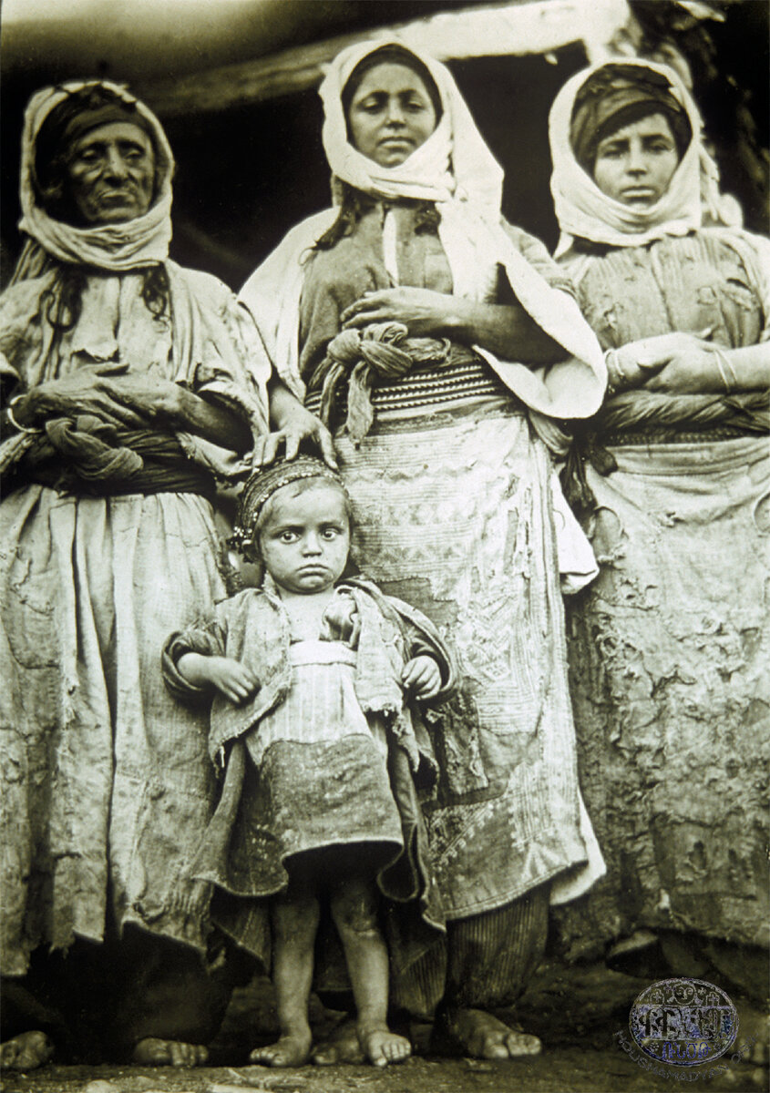
Hazzo-Khabldjoz
Assou, Asou, Asi, Assi, Asiberd, Asi berd [Yenidağan]
38°16'31.69"N, 41°34'16.76"E
Ter-Karapetian: 20 households, Patriarchate: 24 inhabitants, Martirosian: 1,150 inhabitants․
Aymerk, Aymaro, Aymor, Aynmar, Ayn Mar, Amerik, Amerig, Aymerik [Pınarbaşı]
38°10'43.32"N, 41°27'48.37"E
Tevkants: 41 inhabitants, Sassouni: 35 inhabitants.
Aynaras, Aynras [Tosunpınar]
38°13'14.10"N, 41°29'14.64"E
Badrmout, Badermout, Badramout, Baghermout, Patrmout, Patermout, Bardernout [Çınarlı-Taşyuva]
38°21'51.46"N, 41°28'37.54"E
Tevkants: 96 inhabitants, Arax: 23 Armenian and Kurdish households, FO 881-6654: 23 households, Ter-Karapetian: 158 inhabitants, Patriarchate: 175 inhabitants, Martirosian: 200 inhabitants, Teodik: 24 households, Petoyan: 75 inhabitants, genocide survivor Mkrtich Torosyan: 30 households.
Bakhrnas, Bakhernas [Danagöze]
38°14'14.66"N, 41°19'9.74"E
Bashtroum, Bashteram, Bashteram Verin, Pashteram Verin [Yukarıkıratlı]
38°13'5.21"N, 41°22'52.34"E
Tevkants: 160 inhabitants for both upper and lower localities.
Bashtroum, Bashteram, Bashteram Nerkin, Pashteram Storin, Pashteram Vari [Aşağıkıratlı]
38°11'42.18"N, 41°22'46.17"E
Beninou, Binouni, Binounik, Bnunik, Pnounik [Okçular]
38°13'45.61"N, 41°20'58.07"E
Dammokh, Damokh, Tammokh, Tamokh, Tmokh, Timok [Gümüşörgü]
38°15'53.07"N, 41°23'27.33"E
Darakuze, Daraguze [Yolaltı]
38°11'39.20"N, 41°26'31.59"E
Delpi, Delbi, Dlpi [Keseli]
38°15'32.06"N, 41°34'18.30"E
Dera, Tera, Derav [Dereköy]
38°13'25.08"N, 41°22'18.59"E
Tevkants: 70 inhabitants․
Djakour, Chakout, Djakout, Djoghout [Kayadüzü]
38°21'19.81"N, 41°27'56.26"E
Tevkants: 18 inhabitants, Arax: 20 Armenian and Kurdish households, Ter-Karapetian: 5 households, Teodik: 15 households, Sassouni: 15 inhabitants.
Djavzik, Chavzik [Cevizli]
38°16'50.27"N, 41°16'20.07"E
Dodnouk, Totnouk [other known name possibly Dodinik]
Approximate location: 38°11'34.19"N, 41°29'37.31"E. Possibly merged into the Kozluk municipality.
Ter-Karapetian: 3 households.
Dzman, Dzeman, Tzman [Atalar]
38°15'35.48"N, 41°34'59.29"E
Teodik: 5 households.
Dzoghout, Dzorout, Zoghout [other known name Sihot]
38°18'41.18"N, 41°33'32.51"E
Martirosian: 15 households.
Dzork, Zork, Tzork, Dzorik, Zorik [Ergünü]
38°21'33.42"N, 41°27'34.23"E
Teodik: 10 households.
Enkouzenk, Enkouzek [other known name Ayınkozik]
38°15'41.87"N, 41°32'18.17"E
Ter-Karapetian: formerly Armenian but deserted by 1902․
Gelhasanan, Gelhasan, Kelhasan, Kelhasanan [Kelhasan]
38°18'24.75"N, 41°22'56.93"E
Tevkants: 20 inhabitants, Martirosian: 22 inhabitants․
Gelie Sndous, Geliesndous, Kelie Sndous
Location unknown
Petoyan: 22 inhabitants.
Geter, Getkits [Yolüstü]
38°23'3.90"N, 41°28'8.42"E
Tevkants: 16 inhabitants, Ter-Karapetian: 37 inhabitants, Martirosian: 27 inhabitants․
Ghrnadr, Ghernader, Dzrnakhet, Zrnakhet, Zernakhet, Zekrnaket, Zkrnaket, Zanakert [Kalkancık]
38°12'31.61"N, 41°24'18.70"E
Tevkants: 18 inhabitants.
Gomek, Gomekan [Kumlupınar]
38° 8'4.05"N, 41°30'10.32"E
Petoyan: 36 inhabitants.
Haghorda, Haghorta, Hazorta, Hazorda [other known name Hazorta]
38°19'56.67"N, 41°26'22.83"E
Hapshtough, Hapeshtough, Hapshtap
Location unknown
Petoyan: 15 inhabitants, Martirosian: 15 inhabitants.
Hargamo Verin [Bölükkonak]
38°14'19.54"N, 41°24'51.92"E
HargamoNerkin [Bölükkonak]
38°13'38.67"N, 41°25'18.63"E
Harnuvank, Harnvank
Location unknown
Hatni, Harni, Hartni [Çalışırlar]
38°22'30.73"N, 41°29'35.90"E
Tevkants: 48 inhabitants, Ter-Karapetian: 9 households, Martirosian: 30 inhabitants, Petoyan: 70 inhabitants, genocide survivor Mkrtich Torosyan: 60 households․
Hazzo, Khazo, Kharzo, Hazo, Hazro, Hazzoi kaghak, Hzou [Kozluk]
38°11'38.82"N, 41°29'18.65"E
Ter-Karapetian: 856 inhabitants, Patriarchate: 742 inhabitants, Martirosian: 1,180 inhabitants, Petoyan: 3,000 inhabitants, Sassouni: 1,000 inhabitants․
Heghin [Ziyaret]
38°14'24.10"N, 41°15'7.26"E
Hov, Hovgegh [other known name Hov]
38°18'1.11"N, 41°28'23.73"E
Tevkants: 48 inhabitants, Ter-Karapetian: 16 households, Patriarchate: 72 inhabitants, Martirosian: 200 inhabitants, Sassouni: 75 inhabitants, genocide survivor Mkrtich Torosyan: 10 households.
Hrout, Hroutvank, Aroutenk, Arotim [Yürekli]
38°23'50.93"N, 41°29'57.82"E
Tevkants: 120 inhabitants, Ter-Karapetian: 86 inhabitants, Patriarchate: 60 inhabitants, Martirosian: 50 inhabitants, genocide survivor Mkrtich Torosyan: 20 households.
Kanlmank, Kanlman [possibly Ekinlik]
Location unknown
Khabldjoz, Khabeldjoz, Khablchoz, Khabilchoz, Khablshoz, Khabielchoz, Khapildjoz, Gabldjoz, Ghabldjoz, Gablchoz, Gaplchoz, Kaplchoz, Kabildjoz, Gapelchoz-kentron, Sasօun, Enkouzagom [Sason]
38°20'1.50"N, 41°25'13.00"E
Tevkants: 160 inhabitants, Ter-Karapetian: 251 inhabitants, A-Do։ 198 inhabitants, Patriarchate: 364 inhabitants, Martirosian: 410 inhabitants, Teodik: 35 households.
Khalilan [Tunçbilek]
38°13'48.73"N, 41°29'50.01"E
Teodik: 9 households.
Khalilenk, Khalilan, Psank
38°22'27.52"N, 41°25'23.53"E
Kharver, Khalver, Kharvink [other known name Harvink]
38°21'21.93"N, 41°27'45.05"E
Martirosian: 90 inhabitants, Petoyan: 52 inhabitants.
Khezekhtan [other known name Kızıkda]
38°19'35.05"N, 41°34'46.26"E
Khoper, Erour [possibly Yelek]
38°21'56.70"N, 41°27'9.70"E
Arax: 23 Armenian and Kurdish households, Petoyan: 30 inhabitants.
Khoran, Horank, Koronk [other known name possibly Havri]
38°18'56.66"N, 41°20'48.45"E
Petoyan: 41 inhabitants, Sassouni: 10 inhabitants․
Kogh, Gogh [Geçitaltı]
38°16'57.56"N, 41°28'53.11"E
Tevkants: 220 inhabitants, Ter-Karapetian: 20 households, Patriarchate: 200 inhabitants, Martirosian: 260 inhabitants․
Korov, Gorov [Akyemiş]
38°23'24.69"N, 41°29'56.76"E
Ter-Karapetian: 52 inhabitants, Patriarchate: 34 inhabitants, Martirosian: 70 inhabitants․
Kousget, Koutsget, Gousket [Akçalı]
38°19'13.88"N, 41°34'25.84"E
Ter-Karapetian: 30 households, Patriarchate: 610 inhabitants, Martirosian: 1,580 inhabitants, Petoyan: 50 households.
Kousget’s sub-neighborhoods:
- Gomk: Ter-Karapetian: 8 households, genocide survivor Mkrtich Torosyan: 5 households․
- Kotrtser, Kotertser: Ter-Karapetian: 12 households, genocide survivor Mkrtich Torosyan: 10 households․
- Oghngedj, Oghnkesh: Ter-Karapetian: 12 households, genocide survivor Mkrtich Torosyan: 4 households․
- Nerkitagh, Nerkin tagh: Ter-Karapetian: 7 households, genocide survivor Mkrtich Torosyan: 7 households.
- Kartzer: Ter-Karapetian: 10 households, genocide survivor Mkrtich Torosyan: 20 households․
- Gomk Kousgeti: Ter-Karapetian: 15 households․
- Veritagh, Veren tagh, Verentagh, Verin tagh
- Arevkonk
- Armoknin
Lrpnek, Lhnek, Lepnek, Binik [Yazılı]
38°14'57.12"N, 41°32'42.64"E
Ter-Karapetian: formerly Armenian but deserted by 1902․
Manera, Maneran [other known name Maneyran]
38°14'59.13"N, 41°25'49.73"E
Manera Nerkin, ManeranNerkin [other known name Maneyran]
38°14'45.47"N, 41°25'58.85"E
Mankik, Mangik [Geyikli]
38°13'0.90"N, 41°26'0.74"E
Patriarchate: 40 inhabitants, Sassouni: 42 inhabitants.
Mazrakhalk, Mzrekhalk, Mezrekhalk [Gündüzlü]
38°11'46.96"N, 41°24'45.52"E
Mergan, Merka [Çayırlı]
38°13'30.63"N, 41°33'40.85"E
Mergi, Mardji, Merka, Marghe [Değirmendere]
38°12'8.21"N, 41°28'40.27"E
Patriarchate: 12 inhabitants․
Mshkatar, Mshkadar, Mshakatar [Budak]
38°19'45.94"N, 41°32'36.39"E
Ter-Karapetian: 10 households, Patriarchate: 65 inhabitants, genocide survivor Mkrtich Torosyan: 15 households․
Mshrida, Mshrita, Mshrigha [Yedibölük]
38°14'8.56"N, 41°23'28.94"E
Mtghi, Mrtghi, Matghi, Metghi [Arslanlı]
38°12'28.51"N, 41°18'19.27"E
Nadoban, Nadopa, Natopa, Nadopan, Natopan, Nodoban, Natoban [Kayabaşı]
38°19'29.38"N, 41°26'39.49"E
Tevkants: 80 inhabitants, Ter-Karapetian: 15 households, Patriarchate: 70 inhabitants, Martirosian: 270 inhabitants, Sassouni: 10 households, genocide survivor Mkrtich Torosyan: 10 households.
Nerkitagh [Aşağı mahalle]
Approximate location: 38°19'41.89"N, 41°24'49.34"E. Likely merged into the Sason municipality.
Norgegh, Norgyugh, Nor gyugh, Norgegh, Nor-gegh, Gundenou, Gondenou, Yenikyoy [Tekevler]
38°18'46.27"N, 41°23'13.05"E
Tevkants: 120 inhabitants, Ter-Karapetian: 151 inhabitants, Patriarchate: 139 inhabitants, Teodik: 22 households.
Norshen, Norashen [Alıçlı]
38°12'36.57"N, 41°31'4.57"E
Patriarchate: 15 inhabitants, Teodik: 5 households․
Palo, Balou, Palou [İnişli]
38°14'17.54"N, 41°29'53.01"E
Tevkants: 160 inhabitants․
Papour, Papoura [Kayadibi]
38°15'43.98"N, 41°26'0.74"E
Pelav Verin, Belav Verin, Bilav Verin,Pelav [Kilimli]
38°18'16.67"N, 41°21'20.79"E
Ter-Karapetian: 90 inhabitants apparently for both upper and lower localities.
Pelav Nerkin, Pelav Vari, Belav Nerkin, Bilav Nerkin,Pelav [Kilimli]
38°17'33.07"N, 41°22'55.86"E
Psyar, Pesyar [other known name Pisyar]
38°11'6.24"N, 41°31'8.65"E
Rabat, Rabad, Rapat, Rubat, Rubbat, Raba [Yanıkkaya]
38°14'52.55"N, 41°18'15.88"E
Srvandztiants: 5 households, Patriarchate: 112 inhabitants․
Rabi [Arkbaşı, Yukarırabiye and Aşağırabiye]
38°14'10.58"N, 41°32'20.23"E and 38°14'28.45"N, 41°32'9.92"E
Ter-Karapetian: formerly Armenian but deserted by 1902․
Rashik, Rashedara, Rashe dara, Rashedaran, Rashek, Rashekner, Reshik [Çayönü]
38° 7'33.33"N, 41°30'43.93"E
Remkhank, Rmkhank, Remkank, Remgank
Location unknown
Arax: 8 households.
Shat [Kumrular]
38°14'47.41"N, 41°28'7.59"E
Shat Nerkin [Derincik]
38°12'28.70"N, 41°28'51.61"E
Shavelkan [other known name Şevlikân]
38°17'6.92"N, 41°16'55.20"E
Sempan [Karameşe]
38°17'29.00"N, 41°19'59.63"E
Shekhan, Sheykhan, Shekhank, Shekher [Erdemli]
38°19'38.36"N, 41°23'51.84"E
Tevkants: 38 inhabitants, Sassouni: 11 households.
Shelma, Shelmo, Shalmo [Ulaşlı]
38°10'30.62"N, 41°19'15.97"E
Tevkants: 170 inhabitants.
Shouvarink, Shaurank [other known name Şevorik]
38°18'1.14"N, 41°28'23.65"E
Taghaner, Taghener, Daghener, Tazaner [Boğazkapı]
38°21'27.04"N, 41°26'38.74"E
Teodik: 14 households․
Terchoch, Derdjodj, Techouch [Dutluca]
38°14'33.32"N, 41°34'57.73"E
Til, Tele, Tla, Tul, Telli
Location unknown
Teodik: 2 households.
Zangovik, Zengovi, Zngovik, Znkovik [Kocabey]
38° 8'10.53"N, 41°29'3.95"E
Zhrents, Zhretsvank
Approximate location: 38°23'38.69"N, 41°28'10.65"E
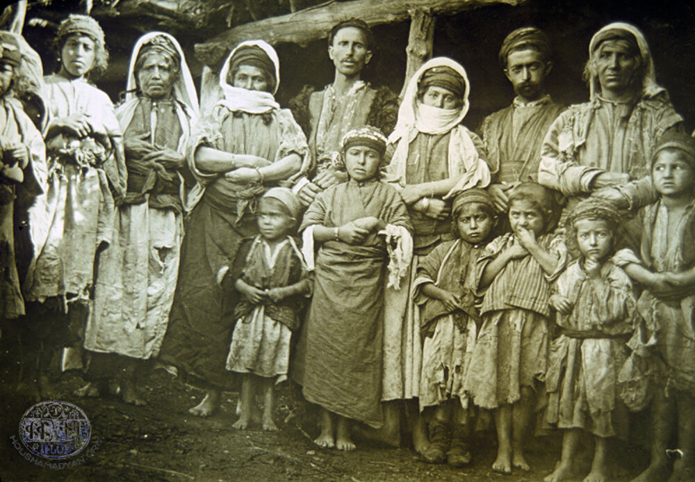
Motkan
Alntsop
Location unknown
Arpi, Arbi, Harpi [Ballı]
38°22'50.84"N, 41°38'55.80"E
Tevkants: 217 inhabitants, Ardzagank no. 18: 99 inhabitants, Mayewski։ 10 households, Patriarchate: 400 inhabitants, Martirosian: 137 inhabitants, Teodik: 30 households, Petoyan: 100 households, Sassouni: 15 households.
Artzvik, Artziv [other known name Arziv]
Approximate location: 38°16'34.09"N, 41°36'55.81"E
Ter-Karapetian: 10 households, Teodik: 30 households, Sassouni: 335 inhabitants.
Artrer, Ardrer, Hardrer [other known name Ertli]
38°18'21.15"N, 41°37'26.99"E
Ter-Karapetian: 20 households, Patriarchate: 39 inhabitants, Martirosian: 64 inhabitants, Sassouni: 35 inhabitants.
Aspndjer Verin, Asbicher Verin, Aspndjir Verin, Ashebner Verin, Ashbner Verin, AghbnerVerin, Aghbzhner Verin [Üstyayla]
38°23'55.00"N, 41°53'33.61"E
Tevkants: 142 inhabitants, Mayewski: 30 households, Ardzagank no. 18: 100 inhabitants, Patriarchate: 516 inhabitants apparently for both upper and lower localities, Martirosian: 316 inhabitants (apparently for both localities), Teodik: 15 households, Petoyan: 80 households (apparently for both localities), Sassouni: 50 households (apparently for both localities).
Aspndjer Nerkin, Asbicher Nerkin, Aspndjir Nerkin, Ashebner Storin, Ashbner Storin, AghbnerNerkin, Aghbzhner Nerkin [İnişli]
38°23'57.70"N, 41°52'49.16"E
Tevkants: 150 inhabitants, Ardzagank no. 18: 91 inhabitants, Mayewski: 20 households, Teodik: 15 households․
Batelmez [Akıncı]
38°25'20.26"N, 41°54'3.20"E
Bnavok [other known name Banavoç]
38°16'33.75"N, 41°40'58.39"E
Bouynout, Boknot, Poknout, Boknot, Boghnout, Boznout, Bouknot, Boghnard, Pougnot [Punut]
38°23'28.34"N, 41°43'18.35"E
Tevkants: 108 inhabitants, Ardzagank no. 18: 97 inhabitants, Patriarchate: 300 inhabitants, Martirosian: 78 inhabitants, Teodik: 11 households, Petoyan: 30 households, Sassouni: 10 households.
Broudk, Broutk [Yeniköy]
38°23'12.60"N, 41°58'46.66"E
Tevkants: 149 inhabitants, Ardzagank no. 18: 84 inhabitants, Ter-Karapetian: 15 households, Mayewski: 20 households, Patriarchate: 155 inhabitants, Martirosian: 138 inhabitants, Teodik: 27 households, Petoyan: 25 households, Sassouni: 8 households.
Chaman, Cheman, Chemi [Çaygeçit]
38°24'40.58"N, 41°50'20.88"E
Teodik: 3 households.
Choman Verin [Yanıkçakır]
38°16'37.44"N, 41°45'57.96"E
Choman Nerkin [Yanıkçakır]
38°16'4.74"N, 41°45'59.23"E
Datvan, Bakhshan [Sekiliyazı]
38°25'30.91"N, 41°53'20.58"E
Petoyan: 60 households.
Djrdo, Djrto, Djrtou, Djertou, Chrtou, Chrto Artre [Seyrantepe]
38°18'0.60"N, 41°38'14.11"E
Martirosian: 108 inhabitants, Teodik: 15 households, Petoyan: 30 households.
Dolak, Dolg [Esenyurt]
38°18'11.89"N, 41°46'1.78"E
Tevkants: 49 inhabitants.
Dolan, Dolank [Yağlıca]
38°23'57.80"N, 41°45'0.98"E
Tevkants: 180 inhabitants.
Dzork [other known name Sork]
38°16'54.49"N, 41°34'48.96"E
Ter-Karapetian: 2 households.
Eghgik, Edgik, Eghig, Yeghik, Yeghegik [Çiğdemalan]
38°16'30.93"N, 41°47'16.14"E
Ardzagank no. 18: 96 inhabitants for Hegh (if identification Eghgik-Hegh is correct)․
Erakh, Yerakh [possibly Uzunyol, other known name İrak]
38°22'44.16"N, 41°47'41.64"E
Gelhok, Gelhog, Glhouk, Gyalhok, Galhok, Kalhok, Kyalhok, Kalhokian, Kalahok, Kelhok [Başçavuş]
38°25'38.47"N, 41°44'45.80"E
Gzekh, Gzegh, Gzeghkh, Nizen, Nezen [Yenibağ]
38°24'16.04"N, 41°55'39.49"E
Tevkants: 140 inhabitants, Ardzagank no. 18: 106 inhabitants, Ter-Karapetian: 15 households, Mayewski: 26 households, Patriarchate: 130 inhabitants, Martirosian: 142 inhabitants, Petoyan: 60 households, Sassouni: 14 households.
Hashkadaran, Hashkataran, Eshkedara [possibly Damlacık, other known names Hişketvan, Hişkederan]
38°14'50.90"N, 41°39'30.62"E
Teodik: 6 households, Petoyan: 7 households, Sassouni: 5 households.
Havoutagh, Khavoutagh, Aboutagh, Havou-tagh, Havtagh [Taşlıpınar]
38°24'35.51"N, 41°55'11.15"E
Tevkants: 105 inhabitants, Ardzagank no. 18: 70 inhabitants, Ter-Karapetian: 8 households, Mayewski: 13 households, Patriarchate: 55 inhabitants, Martirosian: 90 inhabitants, Petoyan: 15 households, Sassouni: 10 households.
Hersan, Hersank, Ersank [Kayran]
38°16'8.14"N, 41°43'34.62"E
&nbs
Hormiz, Hormez, Hormets, Khormiz, Khormouz, Houmez, Hormyouz, Hormouz, Hurmouz, Harpous, Arbous [Taşboğaz]
38°24'11.91"N, 41°46'21.02"E
Tevkants: 120 inhabitants, Martirosian: 132 inhabitants, Petoyan: 60 households.
Hrork [Damarlı]
38°15'52.74"N, 41°36'38.37"E
Teodik: 15 households, Petoyan: 40 households.
KaraboyVerin [Karaboy, Yukarıkaraboy]
38°27'50.09"N, 41°58'57.84"E
KaraboyNerkin [Karaboy, Aşağıkaraboy]
38°28'7.25"N, 41°58'8.30"E
Karp, Karbk, Karb, Kerb [Konuksayar]
38°24'24.43"N, 42° 0'59.87"E
Ardzagank no. 18: 42 inhabitants, Patriarchate: 82 inhabitants, Martirosian: 88 inhabitants, Petoyan: 10 households, Sassouni: 6 households.
Kashakh, Kashagh, Koshakh [Kaşak]
38°19'51.33"N, 41°54'30.20"E
Tevkants: 175 inhabitants, Ardzagank no. 18: 146 inhabitants, Mayewski: 35 households, Patriarchate: 500 inhabitants, Martirosian: 354 inhabitants, Teodik: 27 households, Petoyan: 200 households, Sassouni: 30 households, genocide survivor Avet Gasparyan: 30 households.
Kchotan, Gchotan, Khchitan [other known name Keçutan]
Approximate location: 38°30'35.71"N, 41°52'16.43"E
Kebourtsik, Keybouran, Kervou, Korvou [Gümüşkanat]
38°24'21.10"N, 41°43'59.92"E
Petoyan: 20 households.
Kesk, Kisk [Yuvalı]
38°23'37.24"N, 41°45'35.90"E
Khatk [other known name Hatik]
38°23'23.15"N, 41°49'3.80"E
Khlorik, Khlourik, Hlorink [Kömüryakan]
38°25'57.65"N, 41°58'56.71"E
Khour [Aydın]
38°25'14.39"N, 41°54'43.11"E
Ardzagank no. 18: 97 inhabitants, Mayewski: 20 households, Patriarchate: 105 inhabitants, Martirosian: 127 inhabitants, Teodik: 13 households, Sassouni: 10 households.
Khour, Khourtyank, Gourtian [Kapıkaya]
38°16'36.00"N, 41°48'9.89"E
Petoyan: 30 households․
Kntzou, Kentsou, Kndzou, Kendzou, Gintzou, Gendzou, Gndzou, Gntzou, Ktzou, Ksou, Kesou, Kntsav [Salman]
38°21'27.25"N, 41°51'12.45"E
Tevkants: 315 inhabitants, Ardzagank no. 18: 173 inhabitants, Mayewski: 30 households, Patriarchate: 500 inhabitants, Martirosian: 530 inhabitants, Teodik: 49 households, Petoyan: 50 households, Sassouni: 40 households.
Kor [Ünlü]
38°22'11.61"N, 41°46'14.22"E
Patriarchate: 30 inhabitants, Martirosian: 27 inhabitants.
Kotzonk, Kousenk [other known names Kosunk, Kosunkköy]
38°23'1.94"N, 41°48'12.07"E
Koyans, Kolans, Golants, Kolanis [Geyikpınar]
38°19'8.53"N, 41°48'6.81"E
Krkhou, Kerkhou, Krkho, Grkhou, Gerkhou [Taşyol]
38°18'35.19"N, 41°40'0.98"E
Tevkants: 460 inhabitants, Ardzagank no. 18: 310 inhabitants, Patriarchate: 400 inhabitants, Martirosian: 68 inhabitants, Teodik: 40 households, Petoyan: 100 households, Sassouni: 10 households.
Koukhek, Korkhink [possibly Cevizli]
38°24'54.46"N, 41°45'6.64"E
Marmand, Marmant, Marman, Marmandou gyugh, Marmanta gyugh, Narmand, Narmant [Bağarası]
38°21'25.50"N, 41°44'34.36"E
Patriarchate: 11 inhabitants, Teodik: 3 households, Sassouni: 15 households.
Mtsou, Mtsi, Mtse, Mdzi, Metzi [Açıkalan]
38°20'32.57"N, 41°49'53.45"E
Tevkants: 148 inhabitants, Ardzagank no. 18: 109 inhabitants, Mayewski։ 30 households, Patriarchate: 300 inhabitants, Martirosian: 223 inhabitants, Petoyan: 120 households, Sassouni: 25 households.
Meghkar, Meghvakar [Mikar]
38°24'16.83"N, 41°50'12.21"E
Meretagh, Mere-tagh, Miri tagh, Mirtagh, Veringegh [Mutki]
38°24'30.86"N, 41°55'20.37"E
Tevkants: 41 inhabitants, Ardzagank no. 18: 26 inhabitants, Ter-Karapetian: 7 households, Mayewski: 17 households, Patriarchate: 73 inhabitants, Martirosian: 96 inhabitants, Petoyan: 10 households.
Merkokh, Verkokh [Çanaklı]
38°24'39.01"N, 41°48'51.52"E
Metz dzor, Metzdzor [Alkoyun]
38°27'32.49"N, 41°42'17.91"E
Tevkants: 35 inhabitants, Ardzagank no. 18: 21 inhabitants, Martirosian: 22 inhabitants, Teodik: 10 households, Sassouni: 3 households.
Meydan, Meytan [Meydan]
38°21'39.54"N, 41°46'19.56"E
Mezremiran [possibly Kayadağ, other known names Mezre Mîran, Mızremiran]
38°16'11.52"N, 41°49'54.03"E
Mrtsank, Mrdzank [possibly Örencik]
38°25'36.73"N, 41°41'54.04"E
Tevkants: 105 inhabitants, Ardzagank no. 18: 35 inhabitants, Patriarchate: 50 inhabitants, Martirosian: 74 inhabitants, Teodik: 5 households, Petoyan: 25 households.
Mzouk, Mzrouk, Mzounk, Mzonk, Mzren, Mezren [Dereyolu]
38°23'23.95"N, 41°57'59.24"E
Tevkants: 75 inhabitants, Ardzagank no. 18: 84 inhabitants, Ter-Karapetian: 13 households, Mayewski: 21 households, Patriarchate: 188 inhabitants, Martirosian: 135 inhabitants, Teodik: 16 households, Petoyan: 30 households, Sassouni: 20 households.
Nich, Nidj, Nin, Nish, Nche, Neydjk, Nedjk, Niz [Çatalerik]
38°22'3.40"N, 41°42'38.17"E
Patriarchate: 200 inhabitants, Martirosian: 218 inhabitants, Teodik: 25 households, Petoyan: 40 households, Sassouni: 15 households.
Ourous [Ocaklı]
Approximate location: 38°20'9.25"N, 41°50'4.30"E
Patriarchate: 100 inhabitants, Martirosian: 49 inhabitants, Petoyan: 10 households.
Ouskho, Ouskha, Okhsa [Tosunlar]
38°23'12.58"N, 41°52'19.97"E
Salnadzor, Salanadzor, Salnodzor, Salendzor [Alatoprak]
38°25'22.09"N, 41°49'12.34"E
Sambou, Sampou [Yaygın]
38°26'48.44"N, 41°57'5.42"E
Sghound, Sghount, Slend, Selend, Selent [Yazıcık]
38°16'24.72"N, 41°40'58.60"E
Patriarchate: 400 inhabitants, Martirosian: 328 inhabitants, Teodik: 23 households, Petoyan: 70 households, Sassouni: 70 households.
Shen, Shenek [Karabudak]
38°25'56.39"N, 41°39'39.17"E
Tevkants: 176 inhabitants, Patriarchate: 650 inhabitants, Martirosian: 242 inhabitants.
Shen, Shin [Kaşıklı]
38°22'41.84"N, 41°49'38.19"E
Ardzagank no. 18: 292 inhabitants, Patriarchate: 280 inhabitants, Teodik: 50 households, Petoyan: 60 households.
Sisar, Sesor [Sivrice]
Approximate location: 38°20'5.76"N, 41°51'10.47"E
Spitak djour, Spitakdjour, Avspi [other known names Avesipi, Ava spî]
38°15'23.48"N, 41°41'57.01"E. This village no longer exists.
Tandzi, Tandzik [Yıldız]
38°25'42.07"N, 41°42'39.27"E
Tapler, Habler [Bekçiler]
38°21'57.00"N, 41°43'34.02"E
Tarekavan, Daregavan [Üçadım]
38°21'27.87"N, 41°47'25.43"E
Tevkants: 9 inhabitants.
Taterk [other known name Talirk]
38°22'30.22"N, 41°47'4.78"E
Tghtek [Aydınlık]
38°26'30.04"N, 41°38'46.96"E
Torkh, Korkh [Yuvalıdam]
38°15'11.27"N, 41°44'15.29"E
Vordzenk, Ordzenk, Ordzank, Ourdzenk, Horsenk [Aydemir]
38°23'42.87"N, 41°56'35.18"E
Tevkants: 71 inhabitants, Ardzagank no. 18: 60 inhabitants, Ter-Karapetian: 10 households, Mayewski: 20 households, Patriarchate: 90 inhabitants, Martirosian: 115 inhabitants, Petoyan: 15 households.
Yerkangoti, Yerkayngoti [Kovanlı]
38°23'7.65"N, 41°41'41.87"E
Zander, Zandar, Ghantar [possibly Esen, other known name Zinder]
38°17'43.38"N, 41°52'19.85"E
Tevkants: 84 inhabitants.
Ziaret [Ziyaret]
38°17'8.21"N, 41°51'15.78"E
Tevkants: 902 inhabitants.
- [1] Lynch, Henry Finnis Blosse. Armenia: Travels and Studies, vol. 2: The Turkish Provinces (London; New York: Longmans, Green, & Co., 1901), p. 429.
- [2] Armenian populations in Kharzan, an area of Sassoun located in Sgherd, are excluded from this study.
- [3] Ter-Sargsents, Aristakes (Tevkants). A Journey to Armenia, 1878. Yerevan: Armenian SSR Academy of Sciences, 1985.
- [4] Ardzagank, nos. 18 (Tiflis, 1882), 147 (1894), 150 (1894), and 151 (1894).
- [5] Srvandztiants, Garegin. Toros Aghbar. Constantinople: G. Baghdadlian (Aramian), 1884.
- [6] Arax, vol. 1 (Saint-Petersburg, 1894-1895), pp. 65-95.
- [7] Moorch, no. 8 (Tiflis, 1895), pp. 1154-1155.
- [8] Joint Report of the Consular Delegates to the Sassoun Commission of July 20th, 1895, communicated to Lord Salisbury, October 16th, 1895, in Parliamentary Papers Turkey 1895, no. 1.
- [9] FO 881-6654 Further Correspondence respecting Asiatic Turkey. January to March 1895. London, July 1895; FO 881-6695 Further Correspondence respecting Asiatic Turkey. April to June 1895. London, September 1895; FO 881-6823 Further Correspondence respecting Asiatic Turkey. January to March 1896. London, March 1897; FO 881-6959 Further Correspondence respecting Asiatic Turkey. July to December 1897. London, April 1899; FO 424-208 Further Correspondence respecting Asiatic Turkey. London, 1905.
- [10] The 1902 Armenian Patriarchate of Constantinople census of the population of towns and villages on the Plain of Moush and its environs. Collected by Gegham Ter-Karapetian.
- [11] Mayewski, Vladimir. The Military Statistics of the Van and Bitlis Provinces. Tiflis: Caucasus Military District Headquarters, 1904.
- [12] Ter-Martirosian, Hovhannes (A-Do). The Provinces of Van, Bitlis and Erzerum. Yerevan: Tparan Koultoura, 1912.
- [13] The 1913-1914 Armenian Patriarchate of Constantinople census, Paris: Bibliothèque Nubar de l’UGAB.
- [14] Kévorkian, Raymond, and Paul Paboudjian. Les Arméniens dans l’Empire Ottoman à la veille du genocide. Paris: ARHIS, 1992.
- [15] Martirosian, Nazaret. “Statistics of Eastern Armenian Prefectures Desolated during the First World War.” Van-Tosp, nos. 13, 14, 15 (1916) and 7 (1917).
- [16] Lapjinchian, Teotoros (Teodik). The Calvary of Ottoman Armenian Clergy and its Flock’s Catastrophic Year of 1915. Tehran: S.N., 2014.
- [17] Petoyan, Vardan. The Sassoun Dialect. Yerevan: Armenian SSR Academy of Sciences, 1954.
- [18] Sassouni, Karo. A Story of the Land of Taron. Antelias: The Armenian Catholicosate of the Great House of Cilicia, 2013 [1957].
- [19] Virabyan, Amatuni, ed., Hayots ceghaspanutyune Osmanyan Turqiayum. Verapratsneri vkayutiounner [Armenian Genocide in Ottoman Turkey: The Testimony of Survivors], vol. 2: The Bitlis Province. Yerevan: Zangak-97, 2012.
- [20] Pro Armenia, no. 82 (Paris, 1904), pp. 472-474. The figures in this periodical were in turn borrowed from Hayrenik, no. 244 (Boston, 1904), pp. 3-4.
- [21] See, for example, The 1902 Armenian Patriarchate of Constantinople census, p. 153.
- [22] This information was supplied by Jelle Verheij at the University of Amsterdam to whom I owe thanks for the help with British Foreign Office materials and the verification of present-day village names in Sassoun.
- [23] Massis, February 5 (17), Constantinople, 1881.
- [24] Mshak, no. 28, Tiflis, 1895, p. 1.
- [25] Father Grigor Ter-Grigoryan’s summary report of January 25, 1917 on Turkish and Kurdish atrocities in the villages of Moush and Sassoun, in Virabyan, ed., Hayots ceghaspanutyune…, p. 26.