Kaza of Kharzan – Demography
Author: Tigran Martirosyan, 23/06/2022 (Last modified: 23/06/2022)

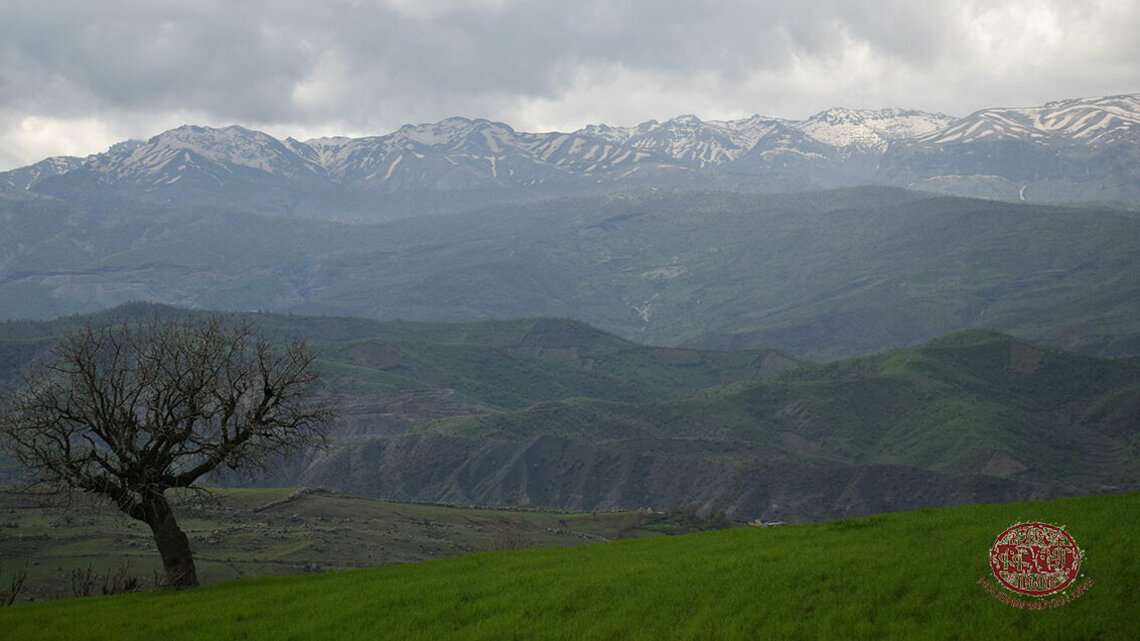
Located in a mountainous, water-rich area known for its fertile land, Kharzan, also called Khaldan, Khaltan, Harzan, and Gharzan, during the late Ottoman era was a kaza (county) in the Sgherd (Siirt) sandjak (prefecture) of the vilayet (province) of Bitlis. [1] Compared to other kazas comprising Sgherd, Kharzan was most heavily populated by Armenians. [2] When in 1875, the Ottoman authorities detached Bitlis and Moush from eyalet of Erzurum to form a new province, the vilayet of Bitlis, several areas that traditionally comprised Sassoun were assigned in subsequent years to different sandjaks. Hence, in the 1890s, Kharzan was transferred to Sgherd, while Hazzo (Kozluk), another traditional area of Sassoun with which in the High Middle Ages Kharzan formed the principality of Sassoun, [3] to Moush. Despite these administrative “adjustments,” which the Ottoman authorities often introduced to ensure that Armenian-populated areas were split into smaller units, Kharzan was still considered a part of Sassoun, as evidenced in various sources used for this study.
The territory of the kaza of Kharzan overlapped that of Aghdzn gavar (county) of the Aghdznik ashkhar (province) of the Kingdom of Greater Armenia, known to the Romans as Arzanene. Tovma Artsruni, a ninth- to tenth-century Armenian chronicler, related that Aghdzn belonged to the members of the princely house of Artsruni, members of an Armenian nobility whose name is believed to have derived from Arzrunik, a variation of the gavar’s name. [4] Arzn, the chief town of the gavar that gave name to Kharzan, was the seat of the bidaxsh, or margrave, of the Aghdznik ashkhar. Arzn was one of the most populous and flourishing cities not only in Aghdznik, but in all of historic Armenia. In different time periods, the city was known as Arzn Aghdznyats, Arzanan, Arzun, Arzrou, Aghdzn, Ardzn, and Arzan. [5] One theory has it that Arzn corresponds to once populous fortress city of Shukaraba, which is how the Assyrians called the settlement, translated from their language as “large market place.” [6]
It was long believed that Armenian king Tigran II the Great founded in the first century BC one of his capitals of Tigranakert at Arzn, on the bank of the Kharzana Get (Garzan Çayı) River, which flows south into Tigris. However, more recent research suggests that Tigranakert might have stood near a hillock called Berd in Armenian or Kale in Turkish (both meaning “fortress”) on the right bank of Baghishodjur (Başur Çayı), a right-bank tributary of Tigris, about 2 kilometers (1.25 miles) southwest of Balekan (see the village list below). [7] In the late nineteenth century, there was, in fact, a ruined village of Kale in the indicated location.
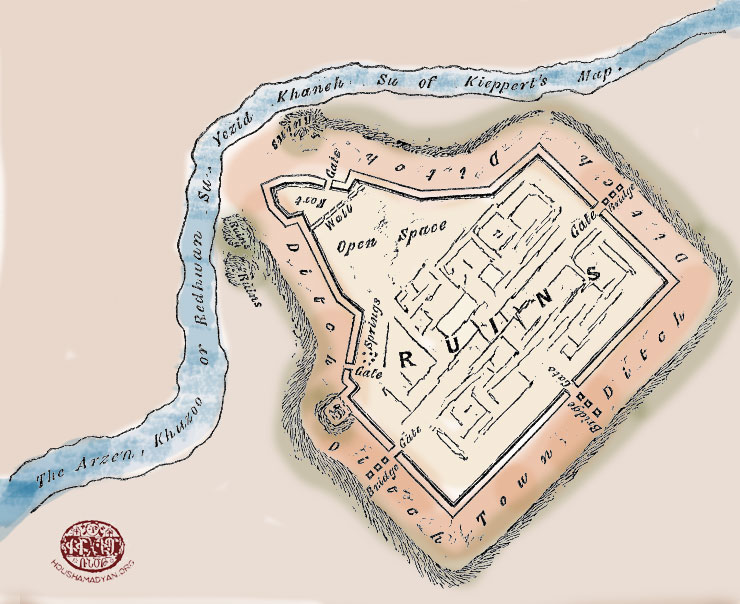
According to John George Taylor, British Consul General for Kurdistan, who in the 1860s travelled extensively in Western Armenia, Kurdistan and Upper Mesopotamia, the ruins of Arzn, which he described as “very extensive,” with the defenses facing towards Kharzana Get (Arzen Su in Taylor’s text), stood on the left bank of the river, close to “the flourishing village of Giri Hassan” (see Gre Hasan in the village list below). [8] The 1902 statistical report prepared by the Sgherd Prelacy suggested that the village of Gerdashen (see the village list below) was the site of Arzn. [9]Throughout the nineteenth century, local Armenians called the site of the ruins Arzna qaghaq (Arzn city) or Grdashen, while Kurds and Turks Xarabe (ruined city) or Eski Diyarbakır (former Tigranakert). [10] The coordinates of the ancient Armenian fortress town of Arzn, currently lying in shambles near a hill called Godeşin tepe (Turkified from the Armenian “Gerdashen”), are 37°58'41.65"N, 41°23'13.35"E.
Other authors identified Arzn with Zokh or Zok, the principal town of the kaza of Kharzan, [11] located near the left bank of Kharzana Get, twenty-two miles (35 kilometers) north-west of Siirt, the homonymous administrative center of the sandjak. Throughout most of the nineteenth century, Zokh was a largely Armenian populated locality. However, the continuous influx of nomadic Kurdish tribes distorted the demographic fabric of the town, gradually transforming it into a settlement with a mixed population. In the early twentieth century, there were about 230 mixed Armenian and Kurdish households in Zokh. The Armenian townsfolk, who spoke a peculiar dialect of the language, [12] still held a considerable numerical strength there.
In the early nineteenth century, Kharzan belonged to the Diyarbakir paşalık, a jurisdiction of a paşa, and was known as Khzou or Hzou. It was mistakenly believed that the paşalık’s chief town of the same name (present-day Yıldızlı) stood on the spot of Arzn. Due to the demographic preponderance of the Yazidis, Armenians, and Syriacs (both Jacobite and Nestorian), which they retained up until the 1870s, Kharzan led a semi-autonomous lifestyle, essentially becoming a principality, with Rndvan serving as its administrative center. In the late nineteenth century, Rndvan had 800 households, [13] which were inhabited by Yazidis, Armenians, Kurds, and Syriacs. The Yazidis were in such large numbers that the town was also known as Yezidcvoc gyough, or Yazidi village, among Armenians, who also made up a large portion of the town’s population.
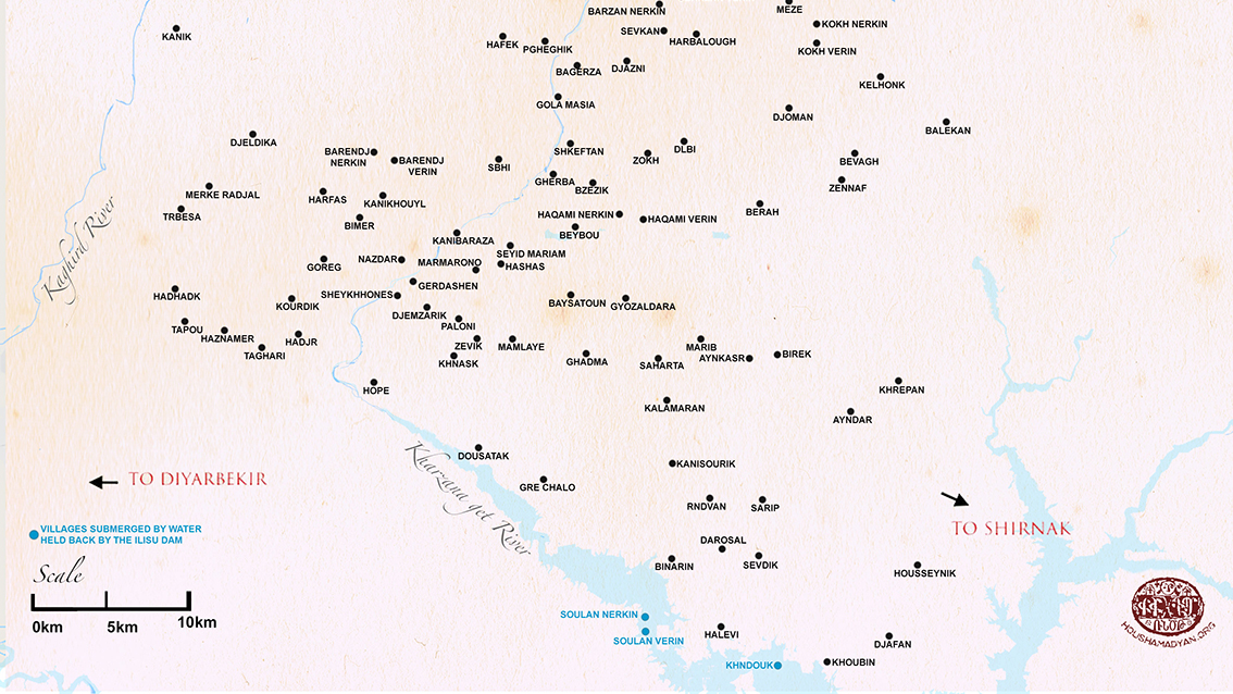
Map of the Armenian-populated villages of the kaza of Kharzan during the Ottoman period. See the current names of the villages in the left column. The map was prepared by Tigran Martirosyan and reworked by Houshamadyan.
In the mid-nineteenth century, the Ottoman authorities set their hands to do away with semi-autonomous existence of Kharzan. After they designated a kaymakam, or district governor, in Rndvan, the Yazidi chieftain of Kharzan was summoned to Diyarbakir, where he was treacherously slain. To deliver the final blow, the Turks returned to old practices of encouraging the resettlement of nomadic Kurdish tribes. The influx of Kurds into Kharzan, belonging to Elmali, Slivani, and Pencenar tribes, led to a mass exodus of the Yazidis to northern Iraq and a significant decrease in Armenian and Syriac populations. By the beginning of the twentieth century, Rndvan lay visibly desolate and deserted, but remained one of the most populous settlements in Kharzan and the chief town of the homonymous village group, called nahiye, in Turkish, with Armenians amounting to around 600 inhabitants in 1914. [14]
Because sources differ on the average household size in the eastern provinces of the Ottoman Empire, where Armenians formed a particularly large portion of the population, in this study, eight will be used as an average number of members per household in rural areas, as suggested by Bishop Vahan Ter-Minassian (Partizaktsi), a Commissioner at the Armenian Patriarchate of Constantinople in the 1860s and 1870s. [15] That said, twenty will be used as an average number of households per village for the vilayet of Bitlis, as suggested by Russian General Staff Colonel Vladimir Mayewski. [16]
In 1882, there were 18,636 inhabitants in Kharzan, including 8,282 Armenians, 1,600 Chaldean Syriacs and 7,599 Kurds. [17] In 1897, the kaza comprised of three nahiyes. [18] In 1910, Azatamart, a newspaper published in Constantinople, reported 54 total villages in Kharzan Central, 49 in Malafan, 43 in Barindj, and 36 in Redvan (the latter three being nahiyes) [19] amounting to 3,640 households or 29,120 inhabitants, if the average numbers of households per village and members per household suggested by Mayewski and Partizaktsi are applied. On the eve of the First World War, Kharzan had a mixed population consisting of Yazidis, Armenians, Syriacs, and Kurds. A census carried out by the Patriarchate in 1913-1914 produced a figure for Armenian populated towns and villages at 76 and the number of households at 942. [20] However, because of ambiguously demarcated county borders, several localities on Patriarchate’s village list, according to other data sources, might have formed part of Motkan (Mutki) and Hazzo-Khabldjoz in Sassoun. The updated Patriarchate census data available to Kévorkian & Paboudjian placed the number of localities in Kharzan in 1914 at 76 and the number of the Armenian population at 8,343 living in 927 households. [21]
During the genocide in 1915, most of Kharzan’s Armenians fled to the mountains of Sassoun, where they suffered the same fate as the local population. As part of the 5,000 Syriacs inhabiting the sandjak of Sgherd, some 1,536 Syriacs from 192 households in the nahiye of Rndvan, [22] received the same treatment as the Armenians. [23] Those Armenians of Kharzan who managed to escape Ottoman annihilation, settled in the town of Qamishli in north-eastern Syria and the neighboring areas. Most of those Armenians were Kurdish-speaking, but there was also a number of Arabic-speakers. [24]
This study relied on a number of sources covering a period of 37 years or from 1878 to 1915. Because these various sources provided discordant and oftentimes conflicting demographic data, no attempt was made to compare the data to produce a conservative estimate of the Armenian population size of Kharzan. Given data discrepancies, hardly is it feasible to make such an attempt. The sources used for this study, in the order of their publication dates, are listed below. Tadevos Hakobyan, Stepan Melik-Bakhshyan, and Hovhannes Barseghyan, authors of the “Dictionary of Toponymy of Armenia and Adjacent Territories,” and periodicals Ardzagank and Mshak, both published in Tiflis, supplied additional data.
- The travel report by Aristakes Tevkants, an Armenian folklorist who journeyed to Western Armenia in 1878;
- The statistical report prepared by the Sgherd Prelacy in 1902;
- The statistical study published in 1904 by Vladimir Mayewski, which covered household counts in the vilayets of Van and Bitlis from either 1890 to 1897 or 1899. [25]
- The 1913-1914 Armenian Patriarchate of Constantinople census, including figures from supplementary Patriarchate census data available to Kévorkian & Paboudjian (1992) and Kévorkian (2012);
- The household count for the localities in Kharzan composed by Varazdat Teroyan, a representative of the American Committee for Relief in the Near East in Armenia in 1919, in the margins of a brochure written in 1912 by Armenian statistician A-Do (Hovhannes Ter-Martirosian);
- The book about the sufferings of the Armenian clergy during the genocide composed by writer Teodik (Teotoros Lapjinchian) in 1921; and
- The Sassoun dialect study by ethnographer Vardan Petoyan published in 1954.
In the earliest account used for this study, Tevkants suggested that there were 45 total villages or 8,280 Armenian inhabitants in Kharzan. Of these villages, thirteen were entirely Armenian populated. However, if the number of inhabitants is calculated on the basis of the breakdown of village populations elsewhere in the author’s travel report, the number of Armenians would total 8,847. In addition to this numerical discrepancy, a few localities in Tevkants’ village list actually belonged to Hazzo in Sassoun, such as, for instance, Hazzo, the chief town of the same name that, according to the author, contained as many as 2,400 inhabitants. [26]
The anonymous author of the article “Namak Sghertic” (A Letter from Sgherd) published in Ardzagank, suggested that in 1882 there were 111 villages or 18,636 inhabitants in Kharzan, of whom 8,282 were Armenian living in thirteen villages, 7,597 Kurdish, 1,600 Syriac, and 1,159 Yazidi. [27] Vital Cuinet, a French geographer, reported that in 1891 there were 138 total localities and that of 13,000 inhabitants 8,800 were Muslim, mostly Kurds, 3,600 Armenian, 258 Jacobite Syriac, and 342 Yazidi. [28] The 1892 Ottoman government annual for the vilayet of Bitlis, called salnamé, counted 18,518 inhabitants, of whom 4,059 were Armenian (3,558 Gregorian, 352 Catholic, and 149 Protestant combined), 12,396 Muslim, 794 Syriac, and 1,269 Yazidi. [29] Referring to an undisclosed source, likely an Ottoman salnamé, Mshak in 1894 reported 9,000 Armenians and 11,000 Kurds in Kharzan and Sassoun Central combined.[30] In 1899, Mayewski placed the total population number at 26,400, of whom 6,717 were Armenians, 18,583 Kurds, and 284 Syriacs. [31] The 1902 statistical report prepared by the Sgherd Prelacy identified 58 Armenian localities containing 608 households, including fifteen Armenian Protestant households. [32] The early twentieth-century Ottoman atlas titled “Memâlik-i Mahrûse-i Şâhâneye Mahsûs Mükemmel ve Mufassâl Atlas” and published in Arabic script, counted 182 total localities in Garzan Merkez (Kharzan Central) and the kaza’s three nahiyes of Melefan (Malafan), Barih (Barindj), and Rıdvan (Rndvan) in 1907. [33]
In the years immediately preceding the genocide, A-Do identified 183 total villages in Kharzan before 1912. [34] In the household count intended as a supplement to A-Do’s statistics, Teroyan reported 35 Armenian localities containing 1,301 households. [35] This total for households would place the number of inhabitants at 10,408, which seems rather excessive. In his correspondence to the Foreign Office, the British High Commissioner in Constantinople placed the total population as of March 1914 at 19,989, of whom 14,541 were Muslims, 4,332 Armenians, and 1,116 other ethnicities. [36] Teodik reported 64 Armenian localities or 1,006 households in 1914. [37] This would place the number of inhabitants at 8,048. Petoyan listed 128 total localities at an unspecified time before the genocide, of which only 21 contained population data amounting to 1,920 Armenian or mixed households. [38] Karo Sassouni, a contemporary journalist and public figure, identified 19 Armenian localities or 1,900 households, which he extracted from Petoyan’s village list. [39]
A census carried out by the Ottoman state before World War I placed the number of Muslims at 14,541, Armenians at 4,332, and the Syriacs at 1,044. [40] Another Ottoman source found in a Turkish collection of archival documents, revealed that in 1915 the number of Armenians in Garzan (Kurtalan), who were to be “relocated and transferred,” as the source chose to call forced deportations, was recorded in Ottoman registries at 2,859. [41] Published by the Turkish General Staff, these registries were drawn up after the Ottoman government on May 31, 1915 (Decree No. 326758/270) decreed “relocation and transfer” of the Armenians residing in areas near the frontlines because, in the view of the authorities, they “were jeopardizing movements of the Ottoman army units resolved to defend the Ottoman borders against enemy forces.” Although the Armenians of Kharzan were nowhere near the frontlines and thus could not “jeopardize” the movements of the army units, many of them were mandated to join the convoys of deportees that were set out on death marches to the places “allocated to them in southern vilayets,” [42] as the Ottoman source chose to denote the deserts near Mosul, Raqqa, or Deir ez-Zor.
On closer examination, it becomes evident that the British High Commissioner has borrowed figures from the Ottomancensus and that the number of Armenians, placed at 4,332, stands at about one-half the census figure drawn up by the Patriarchate. If the total population number reported by the High Commissioner and the census figure for the Armenian population suggested by the Patriarchate are taken as the basis for a calculation, the Armenians would amount to 41 percent of the total population of Kharzan before the war. On the other hand, if using the total of population and the number of Armenian inhabitants in Kharzan suggested by Mayewski, the Armenians would account for a quarter of the kaza’s population at the turn of the twentieth century. This said, Mayewski’s statistics are generally seen as dubious, because they are believed to have drawn heavily on Ottoman salnamés and are therefore almost certainly understated, with the only difference that by multiplying the Armenian households by eight, the Russian Colonel increased the number of Armenian populations by about 40 percent. [43]
The figure appearing in the Ottoman pre-war census gets flimsier when compared with the figure contained in the 1902 statistical report drawn up by the Sgherd Prelacy. When 608 Armenian households are multiplied by eight, the average number of members per household suggested by Partizaktsi, the resulting total of 4,864 is bigger than the Ottoman census figure, despite the lag time of twelve years between the two censuses. Moreover, it is hard to imagine how the number of Armenians, placed by the Ottoman census at 4,332 in 1914, might have fallen 1.5 times in a matter of less than a year to 2,859, if we were to believe the Ottoman deportation registries.
Unless otherwise mentioned, all localities in the village list below were reported by the data sources as being either largely populated by Armenians or had a number of Armenian households or were formerly inhabited by Armenians,along with their current Turkified names placed in square brackets. [44] In cases when verification of the conformity of the pre-1915 village names with their present-day names yielded no results, other known names, including ones that had been in use before they were Turkified starting from the 1920s onwards, as well as some Kurdish name variants, are offered, wherever possible.
Several localities, which some sources identified as belonging to Kharzan, such as Selent [Yazıcık], Hrork [Damarlı], Dzman [Atalar], Crtout [other known name Sırtut], Hashkadaran [Damlacık], Chaman [Çaygeçit], Norshen [Alıçlı], Norgegh [Tekevler], Zangovik [Kocabey], Rashedaran [Çayönü], Gomek [Kumlupınar], Saliba [Karpuzlu], Malager [Düvencik], Lichk [Güneşli], Apekan [Duygulu], Bashteram Verin [Yukarıkıratlı] and Bashteram Nerkin [Aşağıkıratlı], in other accounts were listed as forming part of Motkan (Mutki) and Hazzo-Khabldjoz in Sassoun, and were thus omitted in this study to avoid repetition. The population data for several of these localities can be found in the article “Sassoun–Demography: Population Statistics per Village” via this link: https://www.houshamadyan.org/mapottomanempire/vilayet-of-bitlispaghesh/sassoun/locale/demography.html).

Amino [current name unknown]
The location of this village cannot be determined.
Patriarchate: 10 households.
Aranz, Arans, Alanz, Arandz, Arants, Arnes [current name unknown]
The location of this village cannot be determined.
Sgherd Prelacy: 3 households, Patriarchate: 4 households.
Ayndar, Andar, Antar, Aynghala, Ayintar [Ağaçlıpınar]
37°53'39.42"N, 41°42'16.31"E
Teodik: 4 households.
Aynkasr, Aynkhasr, Ayngasr, Ayn Gaser, Aynghasr, Ayinkasir [Konakpınar]
37°55'23.95"N, 41°37'57.82"E
Tevkants: 240 inhabitants, Sgherd Prelacy: 10 households, Patriarchate: 8 households, Teodik: 3 households․
Badjaft, Badjeft, Badjift, Badhout, Pacheft, Pachift [other known names Bacaft or Bacıft]
The location of this village cannot be determined.
Patriarchate: 16 households, Teodik: 7 households.
Bagerza, Pagerza [Bakırzan]
38° 5'13.66"N, 41°30'40.18"E
Patriarchate listed this locality as a ruined Armenian village in 1913-1914.
Balekan [other known name Belekan]
Possibly 38° 3'19.45"N, 41°46'20.45"E
Patriarchate: 2 households.
Barendj Verin, Barindj Verin, Barinch Verin, Parendj Verin, Parinch Verin [Bahçeli]
38° 2'1.48"N, 41°22'55.26"E
Tevkants: 120 inhabitants, Sgherd Prelacy: 12 households, Patriarchate: 40 households, Teroyan: 40 households, Teodik: 27 households, Petoyan: 60 households, Hakobyan et al.: 60 households in the early twentieth century.
Barendj Nerkin, Barindj Nerkin, Barinch Nerkin, Parendj Nerkin Parinch Nerkin [Bahçeli]
38° 2'18.60"N, 41°22'4.01"E
The figures in the previous entry most likely pertain to both upper and lower localities.
Barzan Verin, Berzan Verin, Verin Barzan, Parzan Verin, Perzan [Taşlık]
38° 7'31.10"N, 41°35'2.83"E
Tevkants: 200 inhabitants, Sgherd Prelacy: 3-4 households (likely for the upper locality only), Patriarchate: 10households, Teroyan: 15 households (for both upper and lower localities), Teodik: 10 households, Petoyan: 40 households․
Barzan Nerkin, Berzan Nerkin, Nerkin Barzan, Parzan Nerkin, Perzan [İncili]
Possibly 38° 7'13.46"N, 41°34'6.96"E
Tevkants: 175 inhabitants, Patriarchate: 8 households, Teodik: 8 households, Petoyan: 15 households.
Baysatoun, Baysetoun, Bisetoun, Paysatoun [Demirkuyu]
37°57'33.42"N, 41°30'23.80"E
Patriarchate: 3 households, Petoyan: 30 households․
Berah, Bara, Bera, Brha, Berhe, Parah, Perah, Pirah [Uluköy]
38° 0'35.59"N, 41°38'25.21"E
Sgherd Prelacy: 5 households, Patriarchate: 35 households, Teroyan: 20 households, Teodik: 35 households.
Bevagh, Bevakhs, Beyhvahz, Peyvahz, Pevahz, Pevas [Karabağ]
38° 2'19.90"N, 41°42'23.69"E
Tevkants: 35 inhabitants, Sgherd Prelacy: 5 households, Patriarchate: 4 households, Teodik: 4 inhabitants.
Beybou, Beybo, Beyba, Bedo, Peto, Peypo [Saipbeyli]
37°59'49.39"N, 41°30'34.48"E
Tevkants: 80 inhabitants, Sgherd Prelacy: 3 households․
Bimer, Pimer, Bimeria, Bimeran, Bimir [Durucak]
38° 0'7.10"N, 41°21'27.35"E
Sgherd Prelacy: 25 households, Patriarchate: 39 households, Teroyan: 35 households, Teodik: 22 inhabitants, Petoyan:50 households.
Binarin, Penarin [Çakıllı]
37°48'46.59"N, 41°34'39.70"E
Patriarchate: 4 households.
Birek, Berik, Brik, Pireg, Brqe, Perq, Birke, Berke, Pirke [possibly Kuyucak]
37°55'33.81"N, 41°39'9.52"E
Teroyan: 50 households, Teodik: 8 households.
Bolend, Polent, Bolound, Bolind, Polint [current name unknown]
The location of this village cannot be determined.
Patriarchate: 5 households, Teodik: 3 households.
Bzezik, Bzezi, Bzezia, Bizezyani, Bekhik, Besik [Günyayla]
38° 1'16.33"N, 41°31'19.78"E
Tevkants: 64 inhabitants, Petoyan: 60 households. The village figures in the Sgherd Prelacy’s 1902 statistical report as an abandoned locality which was formerly populated by Armenians.
Darosal, Darasel Tarosl [Güvercinlik]
37°49'5.85"N, 41°36'50.07"E
Patriarchate: 3 households.
Deshvan, Deshan, Dershvan, Dershevan, Tershvan, Tershevan, Dersevan, Persevan [Karşıyaka]
38° 8'27.39"N, 41°33'36.15"E
Sgherd Prelacy: 5 households, Patriarchate: 2 households, Teodik: 2 households.
Dimsark, Demsarek, Demserk, Dimsarik, Dimsarek, Temserk [current name unknown]
The location of this village cannot be determined.
Tevkants: 160 inhabitants, Sgherd Prelacy: 5 households, Mayewski: 40 households, Patriarchate: 8 households.
Djafan, Djefan, Cheffan, Djeffen [Tulumtaş]
37°46'9.69"N, 41°43'52.15"E
Tevkants: 160 inhabitants, Sgherd Prelacy: 5 households․ Hakobyan et al.: 30 Armenian and Kurdish households in the early twentieth century.
Djazni, Djazne, Djezne, Chezne [Dikbayır]
38° 5'22.69"N, 41°32'45.91"E
Sgherd Prelacy: 3 households, Teroyan: 25 households, Teodik: 16 households, Petoyan: 100 households, Hakobyan et al.: around 100 households before World War I.
Djeldika, Djaldakan, Djaldaka, Djeldakan, Djeldekan, Djeltagan, Djaldeka, Geldeka, Cheltagan, Cheltekan[Ortaca]
38° 2'54.39"N, 41°16'55.51"E
Tevkants: 120 inhabitants, Sgherd Prelacy: 3 households, Patriarchate: 11 households, Teroyan: 50 households, Teodik: 8 households.
Djemzarik, Djmsarib, Chamezarek, Chmsarip, Chmsarik, Chemzark, Voske getak [Gökdoğan]
37°57'10.25"N, 41°24'14.83"E
Sgherd Prelacy: 3 households, Patriarchate: 8 households, Teodik: 8 households.
Djoman, Djomane, Djomani, Djomanik, Chomani, Chomanik, Chuman [Atabağı]
38° 3'45.93"N, 41°39'39.06"E
Tevkants: 840 inhabitants, Sgherd Prelacy: 20 households, Patriarchate: 25 households, Teroyan: 50 households, Teodik: 21 households․
Djouvayc, Djouveyc, Djvahez, Djouveyz, Chvahez, Chouvayz, Chouayz [other known names Zıvahez, Zuveyz, Cuveyz]
The location of this village cannot be determined.
Sgherd Prelacy: 12 households, Patriarchate: 10 households, Teroyan: 12 households, Teodik: 19 households․
Djrman, Chiman [current name unknown]
The location of this village cannot be determined.
Patriarchate: 3 households, Teodik: 5 households.
Dlbi, Dlpi, Dlbe [Aksöğüt]
38° 2'41.34"N, 41°35'13.28"E
Tevkants: 40 inhabitants․
Dlche, Tlche [current name unknown]
The location of this village cannot be determined.
Patriarchate: 1 household.
Dousatak, Dousadak, Dousadek, Dousatag, Dusaduk, Tousatak, Tesetek [Işıkveren]
37°52'28.18"N, 41°26'24.93"E
Sgherd Prelacy: 25 households, Patriarchate: 28 households, Teroyan: 52 households, Teodik: 22 households, Petoyan:60 households, Hakobyan et al.: 60 households in 1880-1914.
Garnek, Garnik, Karnik [current name unknown]
The location of this village cannot be determined.
Teodik: 3 households.
Gerdashen, Gertashen, Gidarashen [other known name Gödeşin]
Possibly 37°58'42.40"N, 41°23'6.30"E
Sgherd Prelacy: 5 households, Mayewski: 40 households․
Ghadma, Khatma, Khatman, Hatma [İncirlik]
37°55'37.63"N, 41°31'2.26"E
Tevkants: 32 inhabitants, Sgherd Prelacy: 7 households.
Gherba, Ghrba, Khrbe, Hirbehungi, Xırbe İbrahim [Taşoluk]
38° 1'33.99"N, 41°29'35.29"E
Petoyan: 40 households.
Gola masia, Golamasia, Golamasi, Golamasiyan, Golemasiyan, Kyolemasian, Dzknalich [Yeşilyurt]
38° 4'10.73"N, 41°29'51.30"E
Tevkants: 210 inhabitants․ The village figures in the Sgherd Prelacy’s 1902 statistical report as a formerly Armenian populated locality that housed a dilapidated Armenian church.
Goreg, Koreg, Koruk [Uğurca]
37°58'44.61"N, 41°19'56.02"E
Sgherd Prelacy: 5 households.
Gre Chalo, Kre Chalo, Girichello [possibly Kütüklü, other known name Giriçello]
37°51'24.20"N, 41°29'13.77"E
Sgherd Prelacy: 8 households․
Gre Hasan, Grehasan, Krehasan, Kre Hasan [other known names Girihasan or Giri Hasan]
The location of this village cannot be determined.
Tevkants: 56 inhabitants, Patriarchate: 9 households.
Gyozaldara, Kyozaldara, Kyozeltere, Gyouzeldere, Gozelder, Keozelter, Geghadzor [Güzeldere]
37°57'27.51"N, 41°32'43.49"E
Sgherd Prelacy: 8 households, Patriarchate: 22 households, Teroyan: 23 households, Teodik: 22 households, Petoyan: 40 households.
Hadhadk, Hadhadgk, Hathatk, Hadhatih [Doğankavak]
37°57'46.57"N, 41°13'36.93"E
Sgherd Prelacy: 30 households, Patriarchate: 46 households, Teroyan: 45 households, Teodik: 44 households.
Hadjr, Hadjre, Hidjri, Hechre [Yolkonak]
37°56'14.31"N, 41°18'51.91"E
Sgherd Prelacy: 3 households․
Halevi, Helevi [Çavuşbayırı]
37°46'27.72"N, 41°36'43.84"E
Patriarchate: 2 households.
Haqami Verin, Haqamik Verin, Veri Haqamik [Yayıklı]
38° 0'6.20"N, 41°33'30.44"E
Tevkants: 42 inhabitants․
Haqami Nerkin, Haqamik Nerkin, Vari Haqamik [Yayıklı]
38° 0'14.59"N, 41°32'23.70"E
Tevkants: 80 inhabitants․
Harbalough, Harpalough, Harbelus [Beybağı]
38° 6'13.72"N, 41°35'43.82"E
Tevkants: 310 inhabitants.
Hafek, Hafik, Hafeg, Khafek [Yankılı]
38° 6'11.76"N, 41°27'28.72"E
Hakobyan et al.: 10-15 households in the early nineteenth century, Patriarchate: 5 households.
Harfas, Harfaz, Herfaz [Beyçayırı]
38° 1'2.01"N, 41°19'51.24"E
Tevkants: 210 inhabitants, Patriarchate: 13 households, Teodik: 9 households.
Hashas, Heshes, Hishis, Hezhez [Gözpınar]
37°58'39.53"N, 41°27'25.83"E
Sgherd Prelacy: 5 households, Patriarchate: 9 households, Teodik: 9 households.
Haznamer, Haznamir, Hznamir, Heznamir, Hiznamir, Haznemir [İnpınar]
37°56'20.40"N, 41°15'42.65"E
Sgherd Prelacy: 12 households, Patriarchate: 28 households, Teroyan: 35 households, Teodik: 25 households, Petoyan: 60 households.
Hoghyar, Khoghdar, Khoghrar [current name unknown]
The location of this village cannot be determined.
Sgherd Prelacy: 5 households․
Hope, Hop, Hob [Asmadere]
37°54'38.63"N, 41°22'2.95"E
Sgherd Prelacy: 20 households, Mayewski: 60 households, Patriarchate: 20 households, Teroyan: 55 households, Teodik: 20 households, Petoyan: 50 households, Hakobyan et al.: 50 Armenian, Kurdish, and Syriac households in the early twentieth century.
Housseynik, Housseyni, Khaseni, Khasseni, Khousseyn, Hyousseyni, Huseyni, Houseynikyoy [Aydemir]
37°48'31.08"N, 41°45'4.69"E
Patriarchate: 5 households, Teodik: 3 households. Hakobyan et al.: 15 households in the early twentieth century.
Kalamaran, Kelameran, Kelemeran, Kalemeran, Odzaberd [Erdurağı]
37°54'4.51"N, 41°34'29.18"E
Sgherd Prelacy: 5 households․
Kanibaraza, Kani baraza, Kanibaraz, Kanibarza, Varazaghbyour, Varazi aghbyour [current name unknown]
37°59'36.10"N, 41°25'32.57"E
Tevkants: 172 inhabitants․
Kanikhouyl, Kani khouyl, Kanikhoul, Ganigoul, Kani goul, Kanigoul, Kanikoul, Kanikol, Tsakaghbyour [Esence]
38° 0'51.46"N, 41°22'24.78"E
Patriarchate: 20 households, Teodik: 9 households.
Kanisourik, Kani Sourik, Kanisorik, Kanisorek, Kanisork, Kanichrek, Kanishragh, Kani Simo, Gani Simo, Simoyi Aghbyour, Simoni Aghbyour [Doruklu]
37°51'57.92"N, 41°34'41.89"E
Sgherd Prelacy: 3 households.
Kanishereg, Kanesherk, Kanishirk, Ganishereg [other known name Kanî Sîrk]
The location of this village cannot be determined.
Patriarchate: 8 households, Teodik: 6 households.
Kelhonk, Kelkokh, Kelhok, Khlok, Gyalhouk, Kalhok [Karakaya]
38° 4'52.90"N, 41°43'33.13"E
Sgherd Prelacy: 8 households, Patriarchate: 12 households, Teroyan: 55 households, Teodik: 10 households.
Khanek, Khanik, Khaneg [current name unknown]
The location of this village cannot be determined.
Sgherd Prelacy: 3 households.
Kanik, Kanek, Kaniki [Samanyolu]
38° 6'25.81"N, 41°13'38.94"E
Patriarchate: 7 households.
Khilka, Khilekan, Khalekan, Khalikan, Khelekan, Khlkan, Halikan [Ardıçdalı]
38°12'23.77"N, 41°42'34.03"E
Patriarchate: 2 households.
Khnask, Khenask, Gengenaske, Kankanas [possibly Avcılar, other known name Ganaski]
37°55'33.29"N, 41°25'25.75"E
Hakobyan et al. suggest that by 1896 this village was abandoned. Sgherd Prelacy: 6 households․
Khndouk, Khendouk, Khandouk, Khentouk, Khntouk, Khoundoukh, Khoundouk, Hendouk [Kaşüstü]
37°45'3.82"N, 41°39'9.27"E
This village has likely been submerged beneath the waters of Tigris as a result of alterations of riverbanks caused by the construction of the Ilısu Dam (Tur. Ilısu Barajı).
Sgherd Prelacy: 15 households, Patriarchate: 6 households, Teodik: 11 households.
Khoubin, Koubin, Ghoubin, Goubin, Goupin, Kuban, Khoupe dare [Atalay]
37°45'18.97"N, 41°41'16.94"E
Tevkants: 200 inhabitants, Sgherd Prelacy: 25 households, Patriarchate: 39 households, Teroyan: 50 households, Teodik: 32 households.
Khoulik, Khoulek, Koulik, Khalek, Goulek, Goulik, Goulleg [current name unknown]
The location of this village cannot be determined.
Sgherd Prelacy: 25 households, Patriarchate: 33 households, Teroyan: 70 households, Teodik: 36 households.
Khrepan, Krivan, Kirivan [Yeniköprü]
37°54'42.16"N, 41°44'18.56"E
Sgherd Prelacy: 5-6 households.
Kokh Verin, Gokh Verin, Gokh [Tütenocak]
38° 6'0.53"N, 41°40'49.64"E
Tevkants: 80 inhabitants (likely for both upper and lower localities).
Kokh Nerkin, Gokh Nerkin, Gokh [Tütenocak]
38° 6'27.42"N, 41°40'51.71"E
See Kokh Verin for population data for both localities.
Kokha, Kokhan, Gokhan [current name unknown]
The location of this village cannot be determined.
Tevkants: 56 inhabitants, Sgherd Prelacy: 2-3 households, Patriarchate: 4 households, Teroyan: 20 households, Teodik: 8 households․
Komika [other known name Gomek]
The location of this village cannot be determined.
A village bearing the name of Gomek figures in the Sgherd Prelacy’s 1902 statistical report as an abandoned locality which was formerly populated by Armenians, Patriarchate: 2 households.
Kotip, Kyotip, Ghatip [other known name Kötip]
The location of this village cannot be determined.
Teodik: 6 households․
Kourdik, Gourtek, Kurtouk [Yeniyol]
37°57'25.45"N, 41°18'33.61"E
Patriarchate: 3 households, Teodik: 3 households.
Kouzalan, Kzelan, Kzela, Kezelan [other known names Kozalan or Ğuzalan]
The location of this village cannot be determined.
Petoyan: 20 households․
Mamagousha, Malakoushan, Mamakish [Uzunyazı]
38° 8'52.93"N, 41°35'5.51"E
Tevkants: 49 inhabitants.
Mamlaye, Mamlaha, Mamla, Mamela, Memla, Aghahank [Çalıdüzü]
37°56'5.69"N, 41°27'55.64"E
Tevkants: 104 inhabitants, Sgherd Prelacy: 15 households, Patriarchate: 10 households, Teroyan: 12 households, Teodik: 10 households, Petoyan: 25 households, Hakobyan et al.: 25 households in the early twentieth century.
Marib, Marip, Mahrib [Possibly Kaynaklı, other known name Mağrip]
37°56'5.04"N, 41°35'50.72"E
Sgherd Prelacy: 2-3 households.
Marmarono, Marmaruna, Marmarona, Marmourana [Akdem or Akdam]
37°58'24.90"N, 41°26'22.13"E
Tevkants: 64 inhabitants, Sgherd Prelacy: 5 households, Patriarchate: 6 households, Teodik: 6 households․
Melha, Melhan [current name unknown]
The location of this village cannot be determined.
Tevkants: 230 inhabitants․ The village figures in the Sgherd Prelacy’s 1902 statistical report as an abandoned localitywhich was formerly populated by Armenians.
Melikan, Milekan, Milikan, Milegan, Mileka [current name unknown]
The location of this village cannot be determined.
Patriarchate: 15 households, Teodik: 16 households.
Melka, Mileka, Milka [current name unknown]
The location of this village cannot be determined.
Tevkants: 80 inhabitants.
Melkishan, Mlkeshan [Kavakdibi]
38°10'6.06"N, 41°21'48.74"E
Sgherd Prelacy: 30 households, Patriarchate: 40 households, Teroyan: 60 households, Teodik: 36 households.
Merina, Merinan, Merena, Merenan, Mirinan, Marianis [current name unknown]
The location of this village cannot be determined.
Mayewski: 30 households, Patriarchate: 12 households, Teroyan: 40 households, Teodik: 27 households.
Merke radjal, Merka radjal, Merka redjal, Merkeradjal, Merkarecha, Murgrecal [Otluca]
38° 1'9.28"N, 41°15'1.43"E
Sgherd Prelacy: 15 households.
Meze, Mizi, Mize [Dedebakırı]
38° 7'20.06"N, 41°39'37.50"E
Patriarchate: 2 households, Teodik: 2 households․
Mlafan, Malafan, Melafan, Melefen, Melfan [Tuzlagözü]
38°10'51.53"N, 41°34'10.84"E
Tevkants: 400 inhabitants, Sgherd Prelacy: 25 households, Patriarchate: 28 households, Teodik: 28 households, Petoyan: 400 households, Hakobyan et al.: 400 Armenian, Syriac, and Kurdish households in 1914.
Nazdar, Naztar [Ürünlü]
37°59'19.88"N, 41°22'19.98"E
Tevkants: 50 inhabitants, Sgherd Prelacy: 7 households, Patriarchate: 3 households, Teroyan: 32 households, Teodik: 1 household.
Paloni, Palonik, Baloni, Palouni [Çakıllı]
37°56'48.23"N, 41°25'40.02"E
Tevkants: 200 inhabitants, Sgherd Prelacy: 8 households, Patriarchate: 8 households, Teroyan: 26 households, Teodik: 8 households.
Patas, Batas [possibly Gedikbaşı, other known name possibly Pertas]
37°57'1.26"N, 41°42'55.15"E
Patriarchate: 9 households.
Pgheghik, Pekhik, Peyik [possibly Yapraklı]
38° 6'0.40"N, 41°29'20.98"E
Sgherd Prelacy: 3 households, Hakobyan et al.: 60 Armenian and Syriac households in 1880-1914.
Qourer, Qoureri, Kourer [Derince]
38° 8'11.81"N, 41°37'37.79"E
Patriarchate: 10 households.
Rndvan, Redvan, Rendvan, Rdvan, Rntvan, Rentvan, Ttvan, Rzvan [Beşpınar]
37°50'45.32"N, 41°36'21.62"E
Sgherd Prelacy: 50 households and additional 15 Armenian Protestant households, Mayewski: 160 households, Patriarchate: 74 households, Teroyan: 150 households, Teodik: 64 households, Petoyan: 400 households.
Saharta, Saarta, Seherdan, Seyerdan, Sarda, Seerta [Çayırlı]
37°55'32.24"N, 41°34'3.66"E
Sgherd Prelacy: 2-3 households, Patriarchate: 18 households.
Salas, Salaz, Salanz [current name unknown]
The location of this village cannot be determined.
Patriarchate: 2 households.
Sarip, Sarib [Kayatepe]
37°50'45.18"N, 41°38'32.95"E
Patriarchate: 10 households, Teroyan: 20 households, Teodik: 4 households.
Sbhi, Sebhi, Sphi, Sephi, Sebhik, Sephik, Suphi [Örensu]
38° 2'4.69"N, 41°27'17.16"E
Tevkants: 9 inhabitants, Sgherd Prelacy: 15 households, Patriarchate: 18 households, Teroyan: 32 households, Teodik: 12 households.
Serkhoshi, Serkhoshik [other known name Serhoşik]
The location of this village cannot be determined.
The village figures in the Sgherd Prelacy’s 1902 statistical report as an abandoned locality which was formerly populated by Armenians. Patriarchate: 6 households.
Sevdik, Soydik, Soytig, Serdik [Yalınca]
37°48'49.98"N, 41°38'22.78"E
This village may no longer exist.
Patriarchate: 12 households.
Sevkan, Seveka, Sevikan [Yemişli]
38° 6'20.22"N, 41°34'20.98"E
Tevkants: 145 inhabitants, Patriarchate: 25 households.
Seyid Mariam, Seyid Meriem, Seyt Merram, Seyit Meyrem, Seyit Meryem, Meriyem [possibly Seyrantepe]
37°59'14.33"N, 41°27'50.85"E
Tevkants: 32 inhabitants․ The village figures in the Sgherd Prelacy’s 1902 statistical report as an abandoned locality which was formerly populated by Armenians.
Shekhosl [current name unknown]
The location of this village cannot be determined. Spelling may not be accurate.
Patriarchate: 3 households.
Sheykhhones, Sheykhhounes, Shekhhounes, Shekhyuns, Shekhunus, Sheykh Yunus, Şeyhyunus Kstashen, Gstashen [Yunuslar]
37°57'34.45"N, 41°23'2.37"E
Patriarchate: 5 households, Teodik: 5 households.
Silakhar, Silakhor, Silaker, Soulga [Kumçay]
37°49'23.53"N, 41°28'56.24"E
This village has likely submerged under the waters of Tigris as a result of alterations of riverbanks caused by the construction of the Ilısu Dam.
Patriarchate: 5 households.
Srdjan, Sedjan, Srchan, Sechan, Serdjan, Takhtekharzan [Güllüce]
38° 8'57.45"N, 41°36'16.46"E
Sgherd Prelacy: 2-3 households, Patriarchate: 2 households, Teodik: 2 households.
Soulan Verin, Soulan Veri [İkiyaka]
37°46'17.33"N, 41°33'31.97"E
This village has likely submerged under the waters of Tigris as a result of alterations of riverbanks caused by the construction of the Ilısu Dam.
Soulan Nerkin, Soulan Vari [Başarı]
37°46'42.28"N, 41°33'36.83"E
This village has likely submerged under the waters of Tigris as a result of alterations of riverbanks caused by the construction of the Ilısu Dam.
Shkeftan, Shkhftan, Shkavta, Shkeftan, Shkefta, Eshkefta [Oyuktaş]
38° 2'37.41"N, 41°30'24.08"E
Sgherd Prelacy: 4-5 households․
Taghari, Takhari, Tkhrek [other known names Tahari or Tağari]
Possibly 37°55'48.50"N, 41°17'17.38"E
Sgherd Prelacy: 8 households, Patriarchate: 18 households, Teroyan: 22 households, Teodik: 1 household.
Tapou, Tapi, Tape [Alıçlı]
37°56'37.98"N, 41°14'1.84"E
Patriarchate: 11 households, Teroyan: 15 households.
Tarosl, Darosal, Darasel [Güvercinlik]
37°49'5.85"N, 41°36'50.07"E
Patriarchate: 5 households.
Telkhan, Telan, Telhan, Telghan, Telgan [Oyacık]
37°57'22.98"N, 41°44'16.64"E
Patriarchate: 13 households.
Tera [current name unknown]
The location of this village cannot be determined.
Sgherd Prelacy: 5 households․
Tozhkan, Tzhzhkan [Uğurlu]
38° 8'57.43"N, 41°35'23.81"E
Tevkants: 74 inhabitants․
Trbesa, Terbesa, Trbesan, Drbesa, Drbesan, Derbesan, Derpesan, Terpesan, Dirbisan [Yaylıca]
38° 0'24.30"N, 41°13'51.68"E
Patriarchate: 4 households.
Vahset, Vaset, Vast [current name unknown]
The location of this village cannot be determined.
Sgherd Prelacy: 1-2 households, Patriarchate: 6 households.
Zennaf, Zinaf, Zinavf,Zinahf, Zinnap [Tosunbağ]
38° 1'23.71"N, 41°41'53.37"E
Tevkants: 126 inhabitants․
Zevik, Zivik [Yoldurağı]
37°56'6.68"N, 41°26'26.18"E
Sgherd Prelacy: 8 households, Patriarchate: 4 households, Teodik: 7 households.
Zokh, Zok, Zoka, Zog, Zoh, Zoghget, Garzan, Gharzan, Fatihbey, Fatih bey [Yanarsu]
38° 2'16.57"N, 41°33'37.54"E
Tevkants: 600 inhabitants, Cuinet։ 200 mixed households, Sgherd Prelacy: 25 households, Mayewski: 200 mixed households, Patriarchate: 30 households, Teroyan: 150 households, Teodik: 200 households, Petoyan: 200 households․
Zvenk, Zevenik, Zevenk [current name unknown]
The location of this village cannot be determined.
Patriarchate: 11 households.

Endnotes
- [1] Hakobyan, Tadevos, Stepan Melik-Bakhshyan, and Hovhannes Barseghyan. Hayastani ev harakits shrjanneri teghanounneri bararan [Dictionary of Toponymy of Armenia and Adjacent Territories], Vol. 2, Yerevan: Yerevan State University Press, 1986, p. 704.
- [2] Tatoyan, Robert. “Arevmtian Hayastani Bitlisi nahangi Sgherdi gavari hay bnakchutian tvakanake Hayoc ceghaspanutian nakhoriakin” [Armenian Population Numbers in the Prefecture of Sgherd of the Western Armenian Province of Bitlis on the Eve of the Armenian Genocide], Journal of Genocide Studies, No. 8 (1), 2020, p. 91․
- [3] Tomaschek, Wilhelm. Sasun und das Quellengebiet des Tigris [Sassoun and the Area around the Sources of the Tigris River], transl. by H. Barnabas V. Bilezikdjian, Vienna: Mekhitarist Press, 1896, p. 61.
- [4] Artsruni, Tovma, and Anonymous. Patmutioun Tann Artsruniats [The History of the House of Artsrunik]. Yerevan: Magaghat, 2006, p. 52.
- [5] Hakobyan et al., Dictionary of Toponymy…, Vol. 1, p. 435.
- [6] Hakobyan et al., Dictionary of Toponymy…, Vol. 4, p. 158.
- [7] Badalyan, Gegham. “Arevmtian Hayastani patmajoghovrdagrakan nkaragire Mets Yegherni nakhorein (mas VIII-rd)” [A Historico-demographic Description of Western Armenia on the Eve of the Armenian Genocide, Part VIII: Sassoun and the Town of Bitlis], Vem, No. 2 (58), 2017, p. 39.
- [8] Taylor, John George. “Travels in Kurdistan, with Notices of the Sources of the Eastern and Western Tigris, and Ancient Ruins in Their Neighbourhood,” The Journal of the Royal Geographical Society of London, Vol. 35, 1865, pp. 21-58.
- [9] Statistical report prepared by the Sgherd Prelacy, 1902, sheet 10.
- [10] Hakobyan et al., Dictionary of Toponymy…, Vol. 1, p. 435.
- [11] Hakobyan et al., Dictionary of Toponymy…, Vol. 2, p. 704.
- [12] Hakobyan et al., Dictionary of Toponymy…, Vol. 2, p. 314.
- [13] Hakobyan et al, Dictionary of Toponymy…, Vol. 4, p. 444.
- [14] The 1913-1914 Armenian Patriarchate of Constantinople census. Paris: Bibliothèque Nubar de l’UGAB, p. 66.
- [15] Massis, February 5 (17), 1881.
- [16] Mayewski, Vladimir. Voenno-statisticheskoe opisanie Vanskogo i Bitlisskogo vilayetov [The Military Statistics of the Van and Bitlis Provinces]. Tiflis: Caucasus Military District Headquarters Press, 1904, p. 26 (Strategic Study section).
- [17] Kévorkian, Raymond, and Paul Paboudjian. Les Arméniens dans l’Empire Ottoman à la veille du génocide. Paris: ARHIS, 1992, p. 504.
- [18] Tekdal, Danyal. II. Abdülhamid döneminde Bitlis vilayeti (İdari ve sosyal yapı) [The Province of Bitlis in the Period of Abdul Hamid II (Administrative and Social Structure)] (PhD diss., Pamukkale Üniversitesi, 2018), p. 38.
- [19] Azatamart, No. 231, March 12, 1910.
- [20] The 1913-1914 Armenian Patriarchate of Constantinople census. Paris: Bibliothèque Nubar de l’UGAB, pp. 65-68.
- [21] Kévorkian & Paboudjian. Les Arméniens dans l’Empire Ottoman…, pp. 60, 504.
- [22] Badalyan, Gegham. “Varazdat Teroyani vichakagrakan nyutere Arevmtian Hayastani bnakavaireri veraberial” [Varazdat Teroyan’s Statistical Materials on Western Armenian Settlements]. The Bulletin of Armenian Archives, No. 1 (105) (2005), endnote 1, p. 220.
- [23] Kévorkian, Raymond. The Armenian Genocide: A Complete History. London: A.R. Mowbray, 2012, p. 340.
- [24] Badalyan, A Historico-demographic Description…, p. 39.
- [25] Dadrian, Vahakn. “The Perversion by Turkish Sources of Russian General Mayewski’s Report on the Turko-Armenian Conflict.” Journal of the Society for Armenian Studies No. 5 (1991), pp. 140, 150.
- [26] Ter-Sargsents, Aristakes (Tevkants). Aicelutioun i Hayastan, 1878 [A Journey to Armenia, 1878]. Yerevan: Armenian SSR Academy of Sciences, 1985, pp. 115-117, 126.
- [27] Ardzagank, No. 9, April 18, 1882.
- [28] Cuinet, Vital. La Turquie d’Asie: géographie administrative, statistique, descriptive et raisonée de chaque province de l’Asie-Mineure, Vol. 2 (Paris: Ernest Leroux, 1891), pp. 612-613.
- [29] Salname-i Vilayet-i Bitlis 1310 [Salnamé of the Vilayet of Bitlis, 1892]. Provincial Document Printing Office, 1308 (1890).
- [30] Mshak, No. 115, October 6, 1894.
- [31] Mayewski, The Military Statistics…p. 222 (Statistical Study section).
- [32] Vichakagrutioun Sgherdi yev ir Temeroun [Statistics of Sgherd and its Dioceses]. The Sgherd Prelacy, 1902.
- [33] Tekin, Rahmi and Yaşar Baş, eds. Osmanlı atlası. XX. Yüzyıl Başları. İstanbul: Osmanlı Araştırmaları Vakfı araştırmaları, 2003, p. 81. (Mehmed Nasrullah, Mehmed Rüşdü, and Mehmed Eşref, Memâlik-i Mahrûse-i Şâhâneye Mahsûs Mükemmel ve Mufassâl Atlas, 1907).
- [34] Ter-Martirosian, Hovhannes (A-Do). Vani, Bitlisi yev Erzroumi Vilayetnere [The Provinces of Van, Bitlis and Erzurum]. Yerevan: Tparan Kultoura, 1912, p. 8.
- [35] Badalyan, Varazdat Teroyani…, pp. 219-220.
- [36] Tableaux indiquant le nombre des divers éléments de la population dans l’Empire Ottoman au 1 Mars 1330 (14 Mars 1914), Constantinople, 14.04.1919, in FO 371/4229, No. 86552, 24.05.1919, cited in Zamir, Meir. “Population Statistics of the Ottoman Empire in 1914 and 1919.” Middle Eastern Studies, Vol. 17, No. 1 (1981), p. 92.
- [37] Lapjinchian, Teotoros (Teodik). Koghkota Trqahye Hogevorakanoutyan yev ir Hotin Aghetali 1915 Tariin [The Calvary of Ottoman Armenian Clergy and its Flock’s Catastrophic Year of 1915]. Tehran: S.N., 2014, pp. 129-131, 762-763.
- [38] Petoyan, Vardan. Sasuni barbaṛe [The Sassoun Dialect]. Yerevan: Armenian SSR Academy of Sciences, 1954, pp. 7, 187-190.
- [39] Sassouni, Karo. Patmutioun Taroni Ashkhari [A Story of the Land of Taron]. Antelias: The Armenian Catholicosate of the Great House of Cilicia, 2013 [1957], p. 339.
- [40] Karpat, Kemal. Ottoman Population, 1830-1914: Demographic and Social Characteristics. Madison: The University of Wisconsin Press, 1985, p. 174.
- [41] Tetik, Ahmet, ed. Arşiv belgeleriyle ermeni faaliyetleri, 1914-1918 Cilt I (1914-1915) [Armenian Activities in the Archive Documents, 1914-1918], Vol. 1: 1914-1915. Ankara: Genelkurmay Basım Evi, 2005, pp. 151, 449.
- [42] Idem, p. 134.
- [43] Tatoyan, Robert. “Arevmtahayutian tvakanaki yev Arevmtian Hayastani bnakchutian etnikakan kazmi harcere Parizi hashtutian konferansin (1919-1920)” [Aspects of Western Armenian Population and Ethnic Composition of Population of Western Armenia at the Paris Peace Conference (1919-1920)], Journal of Genocide Studies, No. 4 (1), 2016, p. 61.
- [44] Non-Armenian readers should be aware that, in this study, the letter Ց ց appearing in Armenian village names and transliterated into C c, should be pronounced as a Z sound, as in the German word Zeitung, and not as an S sound or a K sound, as in the English words.