Kaza of Varto – Monasteries, churches, and places of pilgrimage
Author: Tigran Martirosyan, 22/06/2019 (Last modified: 22/06/2019)

The area around the Pyuragn (Bingöl) Mountains, whose southern slopes stretched through the kaza (county) of Varto was, according to a popular legend, the site of the Biblical Garden of Eden. It was believed that Adam and Eve lived in an area near the eastern slopes of these mountains in the adjacent Khnous (Hınıs) county of the Erzurum province, not far from the village of Haremig or Haramig (present-day Bellitaş) [1] that stood on the left bank of the Khnous River (Kocasu Çayı). During the Kingdom of Greater Armenia, the whole depression south of the Pyuragn (Bingöl) Mountains and centered on the town of Gyumgyum (present-day Varto) was occupied by Arshamunik (otherwise called Ashmounik) kavar, a county located in the eastern part of the kingdom’s Dourouperan ashkhar (province). [2] During the Ottoman era, the eastern and central parts of Arshamounik corresponded to the territory of the kaza of Varto.

Since the fifth century, Arshamunik changed hands between the Mandakouni (Mantagouni) and Mamikonian (Mamigonian) nakharars, members of two of the Armenian princely houses. [3] The village of Dzakhnod in Arshamounik was the birthplace of Hovhannes (Hovhan) I Mantagouni, the Armenian Catholicos from 478 to 490. Subsequently, the county came under the full control of the Mamikonians. The summer residence of sbarabed Vartan Mamikonian, the commander-in-chief of the Armenian army who fell at Avarayr in 451, the battle against Sassanid Persia that ultimately secured the Armenians’ right to practice Christianity, is believed to have stood in Arshamounik. [4] There has been a long-held belief among the local population that the gravesite of the sbarabed, who was canonized by the Armenian Church after his death, was in Ghaladjoukh (present-day Kalecik), a formerly Armenian village situated ten kilometers (six miles) southwest of Gyumgyum on the right bank of the Charbouhar River (Kaynarca Deresi).
From the ninth to the eleventh centuries, Varto was a possession of the Bagratouni/Pakradouni nakharars, members of another Armenian nobility. In fact, the erection of two most remarkable religious edifices in the county which remained in existence until the early twentieth century, was financed by donations from the Mamikonian and Bagratouni princely houses. One was the Red Monastery (in Armenian, Garmir vank or Garmro vank) located near the village of Gundemir (present-day Çayçatı). The other one was the Monastery of Saint James (Sourp Hagop) located near the village of Dodan (present-day İlbey). Both villages have been especially densely populated by Armenians during the late Ottoman centuries.
The influx of semi-nomadic Kurdish tribes during the late eighteenth and early nineteenth centuries distorted the largely Armenian homogeneity of Varto. By the time Ottoman authorities encouraged the resettlement of muhajirs, Muslim refugees from Russia’s North Caucasus—mainly Circassians—in the late-1870s, many Armenian villages were either partly or almost completely deserted. Subsequently, the monasteries and churches that stood in or near those villages were left unattended. During the first decade of the twentieth century, especially between 1901 and 1905, Ottoman authorities facilitated further resettlement of muhajirs. This time around, Chechen muhajirs settled in the formerly Armenian villages that were seized by the Kurds, since the Circassians had already settled there. [5] Because of the exodus of a segment of Armenian villagers, some monasteries and churches in the county have fallen into disrepair or were destroyed by the Muslim new settlers.
According to Armenian folklorist Arisdages Der-Sarksents (Devgants) who visited the area in 1878, around twenty-five monasteries and churches—a few undamaged and many ruined, as shown in his list—were seen still standing in the Armenian or formerly Armenian-inhabited villages in Varto. [6] Several of these, as reported by the writer Kegham Der-Garabedian, remained intact at the turn of the nineteenth and twentieth century, while the ruins of thirty-one other churches, Armenian graveyards, and carved cross-stones khachkars covering most of the county’s territory, could still be found. [7]
British author Christopher de Bellaigue suggested that in 1914 eight churches catered to the Armenians of Varto. [8] Based on the Armenian Patriarchate of Constantinople census data, French Armenian historians Raymond Kévorkian and Paul Paboudjian reported seven churches and three monasteries in the county that remained intact before the outbreak of the First World War. [9]
Within a century after the genocide, all monasteries and churches in Varto—both dilapidated and those still functioning during the period leading up to 1915—along with Armenian cemeteries, khachkars, and places of pilgrimage, were completely destroyed.
The vice-prelacy of the Armenian Apostolic Church in Varto administratively reported to the prelacy in Moush located 49 kilometers (30 miles) south of Gyumgyum, the principal town of the county and the seat of the vice-prelate. The jurisdiction of the Moush prelacy extended over the counties belonging to the sandjaks (prefectures) of Moush and Gench (Genç) of the vilayet (province) of Bitlis, Varto being one of them. [10] In the years before the genocide, the vice-prelate of Varto was Pastor Nerses Der-Hagopian, a native of the town of Moush. [11] Ordained in 1913 by Bishop Nerses Kharakhanian, the prelate of Moush who died on April the tenth, 1915, and did not witness the annihilation of his people [12] that started fourteen days later, Father Der-Hagopian shared the fate of tens of thousands of Armenians of Moush, who were subjected to forced deportation and mass murder during the genocide. Along with several clergymen serving in the Varto villages of Gundemir, Dodan, and Paskan, [13] he was killed in 1915. [14]

This study relied on a number of sources some of which can be found in the articles “Kaza of Bulanik—Monasteries, churches, and places of pilgrimage” (http://www.houshamadyan.org/en/mapottomanempire/vilayet-of-bitlispaghesh/kaza-of-bulanik/religion/churches.html), “Kaza of Malazgirt—Monasteries, churches and places of pilgrimage” (https://www.houshamadyan.org/en/mapottomanempire/vilayet-of-bitlispaghesh/kaza-of-malazgirt/religion/churches.html), and Varto-Demography (https://www.houshamadyan.org/en/mapottomanempire/vilayet-of-bitlispaghesh/kaza-of-varto/locale/demography.html). The 1878 travel guide by Arisdages Devgants, the 1902 Armenian Patriarchate of Constantinople census of the population of towns and villages on the Plain of Moush and its vicinity collected by Kegham Der-Garabedian, the guidebook about the monasteries of Daron compiled by the same author in the late-1890s, and the treatise on the Daron-Douruperan monasteries published in 1953 by philologist Hamazasb Vosgian, provided supplementary data.
One important source of information on the monasteries and churches in Varto is the lists of churches and monasteries by village for the Moush sandjak submitted by the Armenian Patriarchate of Constantinople to the Ottoman ministry of justice and religious minorities in 1912 and 1913. For unknown reason, however, the lists left out Varto and three other Armenian-populated counties of the Moush prefecture: Bulanik, Sassoun, and Malazgirt, thus restricting the count to 82 monasteries and churches in the town of Moush and the villages of the Plain of Moush. [15] Other source suggests that inclusive of Varto, Bulanik, and Malazgirt in the Moush sandjak, as well as the adjacent province of Batman and the Hizan sub-district (nahiye) of the Bitlis kaza, the number of Armenian churches prior to the genocide amounted to 148. [16]
Below is a list of monasteries, churches, and places of pilgrimage in the kaza of Varto during the late Ottoman era. Wherever possible, the list includes information regarding the number and names of the clergymen, which were obtained from the 1902 Patriarchate census data collected by Der-Garabedian, the brochure about the sufferings of Armenian clergymen written in 1921 by Armenian writer and publisher Teotig (Teotoros Lapchinchian), and the book on the losses of the Armenian clergy during the genocide written in 2009 by Bishop Papken Charian. Unless otherwise stated, the information submitted below is drawn from primary sources covering a period of about thirty years or from the mid-1880s to 1915.
Monasteries of the Varto county
There were a few monasteries or convents, both undamaged and ruined, in the kaza of Varto. As in other counties of Moush, in Varto the half-ruined or ruined convents were called shapatatsial or anabadatsial in Armenian. The 1902 Patriarchate census of the population of towns and villages on the Plain of Moush and its vicinity listed five monasteries that remained intact or were in a dilapidated state. [17] The 1913 Patriarchate census listed one monastery. Kévorkian and Paboudjian, authors of the treatise Armenians in the Ottoman Empire on the Eve of the Genocide, raised the figure to three, using supplementary Patriarchate census data available to them. [18]
The Monastery of Saint James (Sourp Hagop) at Darabi
Near the village stood the dilapidated Sourp Hagop monastery. Der-Garabedian suggested that the monastery was an ancient edifice and by the early twentieth century was known under the name of “Darabi convent” (in Armenian, Darabi menasdan). [19]
Derik (Anera Derik)
An unverified source suggests that near the village stood ruins of an unnamed monastery.
Derik (Varto Derik)
An unverified source suggests that near the village stood ruins of an unnamed monastery.
The Monastery of Saint James (Sourp Hagop) at Dodan
The monastery stood not far from Dodan, on an eminence, about seven-eight minutes’ walk northward from the village. According to Der-Garabedian, by the early twentieth century the monastery was already abandoned and was in a dilapidated state. [20] Vosgian concurred that the monastery stood near the village. [21]
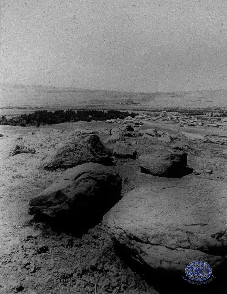
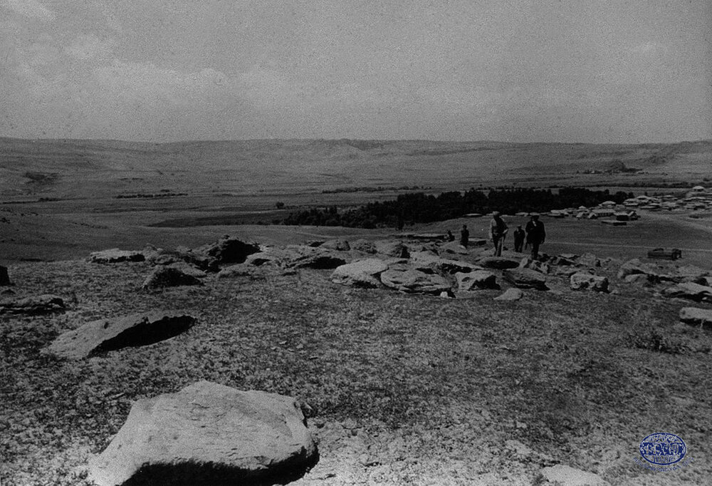
The Red Monastery (Garmir vank) at Gundemir
At the site of the ruins near the village once stood a monastery, called “Red Monastery” (in Armenian, Garmir vank or Garmro vank). The monastery was built of stone and was long abandoned. Der-Garabedian reported that Armenian villagers unearthed its ruins in the early-1870s. [22] Vosgian concurred that a monastery named Garmir or Garmro vank stood near the village. [23] There was another dilapidated monastery, the ruins of which were ten minutes away northward from the village. According to Der-Garabedian, this edifice once was a walled convent with a monastic graveyard nearby.
The Monastery of Holy Savior (Sourp Amenaprgich) at unknown location
The location of this monastery is unknown, supposedly near Gundemir. The monastery apparently was one of many shapatatsial convents in Moush. Der-Garabedian suggested that the ruins stood on a rocky hillock, called krnen or kran (քըռնեն, քռան)in the local parlance. Over the centuries the hillock reduced to a mere bump, called terpoug (դերբուկ) in Armenian, near which sprang a springlet. [24] Vosgian concurred that the monastery lay in ruins on a hillock at an unknown location in Moush. [25]
Khangar monastery (Khangar or Khangari vank) at Gyumgyum
Der-Garabedian reported that a dilapidated monastery called Khangar vank stood about a quarter of an hour northward from the town. The monastery name was not unusual for Moush. In Malazgirt, there was another monastery called Khangar.

Unnamed monastery at Gyumgyum
The 1913 Patriarchate census listed one unnamed monastery in the town. Der-Garabedian reported an unnamed dilapidated monastery with a monastic graveyard nearby.
The Monastery of Saint Matthew (Sourp Mateos) at Oustukran Verin and Oustukran Sdorin
Another shapatatsial convent stood near these twin villages. According to Der-Garabedian, by the early twentieth century all that was left of this religious edifice was its name. [26] Vosgian concurred that the monastery stood near an Oustukran village and had long decayed into ruins. [27]
Churches of the Varto county
In the late nineteenth century and prior to the genocide, there were more than eighty Armenian or formerly Armenian-inhabited or mixed-population villages in the kaza of Varto. Almost every Armenian village had a church; larger ones had two churches. There were also ruins of religious edifices that stood especially to the north of the town of Gyumgyum in the direction of the Pyuragn (Bingöl) Mountains near Zadsheykh (present-day Acarkent), a locality situated five kilometers (three miles) north of Gyumgyum. Almost every functioning church had serving clergy. Ottoman salnamés, government annuals containing statistical data for the state and provinces, stated that in 1871, 1872, and 1873 in Varto there were four Armenian churches for these three years. [28] The 1902 Patriarchate census of the population of towns and villages on the Plain of Moush and its vicinity listed around 39 churches, 31 of which lay in ruins in the formerly Armenian-inhabited villages that were taken over by the Kurds. The 1913 Patriarchate census listed five—apparently functioning—churches in the county, a figure that Kévorkian and Paboudjian raised to seven, using supplementary Patriarchate census data available to them. [29] Listed below are the villages in Varto, along with their present-day names placed in brackets, which housed Armenian churches.
Alagyoz Verin [Yukarıalagöz]
One unnamed dilapidated church, khachkars, and a graveyard.
Amaran [Onpınar]
Both Devgants and Der-Garabedian reported one unnamed dilapidated church. Apparently reporting the same church, de Bellaigue added that in the first decade of 2000 its ruins were reduced to a mound and that the church stood in the upper quarters north of the village which were said to have been richer because they were inhabited by Armenians. According to Teotig, priests serving at other churches in Varto catered to the parishioners of this village. [30]
Aner [Değerli]
The Church of Saint James (Sourp Hagop). According to Der-Garabedian, Sourp Hagop was an ancient church, which was renovated in the late-1890s. To the east of the village stood ruins of the Church of Saint Sarkis (Sourp Sarkis). Sarkis was a general in the army of Roman emperor Constantine I and had converted to Christianity. He was put to death by a Persian Shah for refusing to convert to fire worshipping. The saint was held in reverence insomuch that local Armenians would observe a fast for him. Near the village there were ruins of another edifice, the Church of Saint George (Sourp Kevork). According to Teotig, priests serving at other churches in Varto catered to the parishioners of this village. [31]
Arapo [Çiçekli]
One unnamed dilapidated church, khachkars, and a graveyard.
Baghlu [Bağlıisa]
One unnamed dilapidated church, khachkars, and a graveyard.
Charbouhour [Bağiçi]
One unnamed dilapidated church, khachkars, and a graveyard. An unverified source suggests that the church was known under the name of the Church of Holy Resurrection (Sourp Haroutyun).
Derik (Anera Derik) [Kumlukıyı]
One unnamed dilapidated church.
Diadin [Ölçekli]
One unnamed dilapidated church, khachkars, and a graveyard.
Dodan [İlbey]
The Church of Saint Toros (Sourp Toros). According to Der-Garabedian, Sourp Toros was built of wood. One serving clergyman, Father Mgrdich. Devgants reported the Church of Saint George (Sourp Kevork).
Gundemir [Çayçatı]
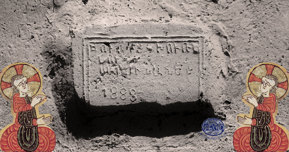
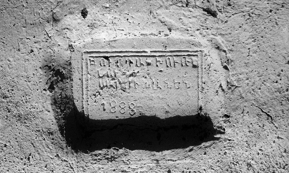
The Church of Saint Toukhmanoug (Sourp Toukhmanoug). In Moush, there were many churches named toukh manoug, meaning “swarthy lad.” Sourp Toukhmanoug was a Kurdish boy who converted to Christianity and suffered martyrdom at the hands of his Muslim co-religionists. He was later sanctified by Armenians. Built of stone, this ancient church, according to Der-Garabedian, was renovated in 1871. Two serving clergymen, Father Boghos Der-Kevorkian and Father Garabed. Henry Lynch, an Irish geographer who visited Gundemir in the late-1890s, described the locality as a village of considerable size, which possessed “an ancient church and the houses cluster round it, rising up the slope of a little eminence from the plain.” [32] Devgants reported the Church of the Holy Mother of God (Sourp Asdvadzadzin).
Gyumgyum [Varto]
The Church of Saint James (Sourp Hagop). Der-Garabediansuggested that the church was built of stone and was known under the name of Saint Vartan (Sourp Vartan) before the completion of renovation works in 1891. In fact, of all known churches in Moush only this particular church bore the name of Vartan Mamigonian, which suggests that the entrenched beliefamong Varto Armenians thatthe county housed thesbarabed’s summer residence and was the location of his gravesite, mighthave some basis in reality. One serving clergyman, Father Khachadour.Der-Garabedian reported another dilapidated church at Gyumgyum that bore the name of Sourp Hagop,Kurdified to “Hakhob”by the local Kurds. Devgants reported the Church of Saint George (Sourp Kevork).
Habiban [Haksever]
One unnamed dilapidated church, khachkars, and a graveyard.
Hadjibeg Verin [Yukarıhacıbey]
One unnamed dilapidated church, khachkars, and a graveyard.
Hasanova [Hasanova]
The Church of Saint George (Sourp Kevork) was an ancient edifice renovated in 1874. A soldier in the Guard of Roman emperor Diocletian who ordered his death for failing to recant his Christian faith, George became one of the most venerated saints in Christianity and was revered in Moush for his ability to cure ills. Tatevos Hagopian, Sdepan Melik-Bakhshian, and Hovhannes Parseghian, authors of the Dictionary of Toponymy of Armenia, suggested that the village housed an unnamed church, which was built in 1261. [33] There were also two dilapidated churches at the village: the Church of Saint Simon (Sourp Shmavon) and another unnamed church. Devgants reported one unnamed dilapidated church.
Ilanle [Yılanlı]
One unnamed dilapidated church, khachkars, and a graveyard.
Inakh [Yenimahalle]
One unnamed dilapidated church, khachkars, and a graveyard.
Karashen [Karameşe]
One unnamed dilapidated church, khachkars, and a graveyard.
Karkarout [Sazlıca]
One unnamed dilapidated church, khachkars, and a graveyard.
Kchan [Seki]
One unnamed dilapidated church, khachkars, and a graveyard.
Kers [Boylu]
One unnamed dilapidated church, khachkars, and a graveyard.
Kestamert [Çobandağı]
One unnamed dilapidated church, khachkars, and a graveyard.
Kharakhou [Karaköy]
One unnamed dilapidated church, khachkars, and a graveyard.
Khashkhash [Eryurdu]
One unnamed dilapidated church, khachkars, and a graveyard.
Kholar [Kolan]
Hagopian et al. suggested that the village housed an unnamed Armenian church. [34]
Kilisok [Kiliseli]
The present-day name of the village, Kiliseli, translated from Turkish as “the churches,” suggests that there could have been ruins of an Armenian church or monastery in or near the village.
Kmsor [Kaygıntaş]
One unnamed dilapidated church, khachkars, and a graveyard.
Koshkar [Yarlısu]
One unnamed dilapidated church.
Kotan [Güzelkent]
One unnamed dilapidated church, khachkars, and a graveyard. Kotan is not to be confused with the homonymous locality situated 3 kilometers (two miles) north of the village.
Mergemet [Çayıryolu]
One unnamed dilapidated church which, according to Der-Garabedian, originally could have been a monastery.
Mousian [Beşikkaya]
One unnamed dilapidated church, khachkars, and a graveyard.
Paskan [Kaynarca]
The Church of Saint Sarkis (Sourp Sarkis). According to Der-Garabedian, the church was built of wood and was renovated on the site of an ancient sanctuary. One serving clergyman, Father Vartan Der-Vartanian. Der-Garabedian reported that two ancient gospels hand-written on parchment and called ShekAvedaran and Tavti Avedaran, were kept in the church. There was another unnamed and dilapidated church near the village, which in earlier times purportedly was a monastery. The graveyard that stood nearby had khachkars. In the recent years, as reported by de Bellaigue, a new mosque outside the village was built on the site of an Armenian church.
Rakhasan [İçmeler]
One unnamed dilapidated church, khachkars, and a graveyard.
Randouli [Buzlugöze]
One unnamed dilapidated church, khachkars, and a graveyard. According to Der-Garabedian, up until 1892 a gate lock of the John the Baptist (Sourp Garabed) monastery, one of the most important sanctuaries of the Armenian Christian pilgrimage in Moush and in all of the Armenian Highlands located 22 kilometers (fourteen miles) southeast of the village, was kept at Randouli, presumably with the village priest.
Sachak [Alnıaçık]
One unnamed dilapidated church, khachkars, and a graveyard.
Selikan [Ulukapı]
The Church of the Holy Mother of God (Sourp Asdvadzadzin). According to Hagopian et al., the church was built in 1276. Sourp Asdvadzadzin, who was called Balak kounpet, Ganach chounbar, Khatoun yeghnig Sourp Diramer in the Moush dialect, was feared for her ability to affect sinners with leprosy.
Shekhpir [Göltepe]
One unnamed dilapidated church, khachkars, and a graveyard.
Sofian [Doğanca]
One unnamed dilapidated church, khachkars, and a graveyard.
Toghtap [Döğdab]
One unnamed dilapidated church, khachkars, and a graveyard.
Yeramatan [present-day name unknown]
One unnamed dilapidated church, khachkars, and a graveyard.
Zadsheykh [Acarkent]
One unnamed dilapidated church. According to Der-Garabedian, a section of a rocky hillock near the church ruins was beautifully carved into a khachkar.
Places of pilgrimage in the Varto county
In addition to monasteries and churches, there were chapels, undamaged or fragmented khachkars, spring-wells, shrines, and monastic cells called djknadeghi in Armenian that Varto Armenians regarded with reverence as they went there on pilgrimages or for veneration. The longest pilgrimage occurred after Easter, when for forty days the villagers would go to the many places in the county and beyond that they considered sacred. The pilgrimage was followed by occasional daily or weekly fasts. There were several known sites in Varto that were considered sacred by the locals.
Hermit’s cell at Aner
To the north of the village there was a hermit’s cell which the locals apparently visited for veneration.
Spring-well at the Saint James (Sourp Hagop) monastery at Darabi
Near the dilapidated Sourp Hagop monastery, also known as “Darabi convent,” sprang a well that was considered sacred, with a grove nearby.
Saint James (Sourp Hagop) monastery at Dodan
Although abandoned and half-ruined at the turn of the twentieth century, the Sourp Hagop monastery, according to Der-Garabedian, was considered a place of pilgrimage. [35]
Saint John the Baptist (Sourp Garabed) monastery
The territorial area administered by the Sourp Garabed monastery included the Armenian-inhabited villages in Varto, along with other counties belonging to the sandjak of Moush. [36] Varto villagers would go on a pilgrimage to the monastery, which was located 29 kilometers (eighteen miles) southwest of Gyumgyum in what is now the Zaza hamlet of Çengilli, to ask Saint John the Baptist at Moush, known as Msho Sultan Sourp Garabed in the local parlance, to grant them the desires of their hearts. After Easter and until the feast of Transfiguration of Jesus (Vartevar or Vartavar), villagers would observe a daily and weekly fast for Sourp Garabed.
Vartan Mamigonian’s alleged gravesite at Ghaladjoukh
An unverified source suggests that it was the locals’ long-held belief that this village housed a tomb that was attributed to the gravesite of Saint Vartan Mamigonian. After the Kurds settled in the village, the Armenian shrine was seized and turned into a ziyarât, Kurdish for “shrine,” subsequently becoming a place of their own pilgrimage.
Koshkarbaba sanctuary at Koshkar
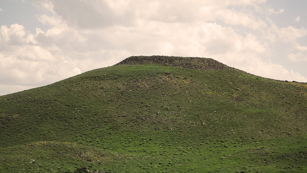
Near the village there was a sanctuary called “Koshkarbaba,” which apparently took its name from the nearby mountain. Mount Koshkarbaba rose south of the Pyuragn (Bingöl) Mountains near the source of the Gyumgyum River (Koskar Deresi). Koshkarbaba, possibly a shapatatsial convent or a ruined chapel or a terpougor a khachkar, was considered a sanctuary not only by the Armenians, but also the Kurds belonging to the Hormek (Khoramaktsi) tribe, who made their own pilgrimages there.
Noreloug chapel at Gundemir
After the ruins of the Red Monastery (Garmir vank) at Gundemir were unearthed in the early-1870s, they were converted by the villagers to a chapel, which was given the name “Noreloug,” meaning “a new-built” in Armenian. Built of wood, the chapel was considered a place of pilgrimage. [37]
Spidag aghpyur at Gundemir
The name of this sanctuary, translated from Armenian as “white spring-well,” suggests that it was apparently a spring-well, whose water was considered sacred. Beautiful khachkars stood nearby. In fact, there were quite a few spring-wells elsewhere in Moush, typically near undamaged or dilapidated monasteries, which were regarded with reverence. These were called Lyusaghpyur, that is, waters that “throw daylight,” Gatnaghpyur, or waters that tasted “like milk,” and Shakaraghpyur, or waters that tasted “like sugar.”
Saint Paul (Sourp Boghos) and Saint Peter (Sourp Betros) sanctuaries at Gundemir
Two other sanctuaries at the village were visited by the faithful for veneration on and imediately after the day of the feast of Hampartsoum (the Ascension of Jesus), one of the religious feasts and rituals observed in Moush. Named after two of Christ’s apostles, these sanctuaries were possibly shapatatsial convents or ruined chapels or terpougs or khachkars. The one that was called Sourp Boghos was visited on the feast day. The other one, called Sourp Bedros, was visited the day following the feast.
- [1] Hovhannes Zadigian, Կարինի նահանգը 19-րդ դարի երկրորդ կէսին [The Province of Garin in the Second Half of the Nineteenth Century], Noravank, Yerevan, 2013, p. 231.
- [2] Tatevos Hagopian, Հայաստանի պատմական աշխարհագրութիւն [Historical Geography of Armenia], chapter 3, Yerevan State University Press, Yerevan, 2007, p. 155.
- [3] Thomas Alan Sinclair, Eastern Turkey: An Architectural & Archaeological Survey, volume I, The Pindar Press, London, 1987, p. 320.
- [4] Teotoros Lapchinchian (Teotig), Գողգոթա թրքահայ հոգեւորականութեան եւ իր հօտին աղէտալի 1915 տարիին [The Calvary of Ottoman Armenian Clergy and its Flock’s Catastrophic Year of 1915], Tehran, 2014, p. 138.
- [5] Georgi Chochiev and Bekir Koç, “Migrants from the North Caucasus in Eastern Anatolia: Some Notes on Their Settlement and Adaptation (Second Half of the 19th Century-Beginning of the 20th Century),” in Journal of Asian History, vol. 40, No. 1 (2006), p. 92.
- [6] Arisdages Devgants, Այցելութիւն Ի Հայաստան,1878[A Journey to Armenia, 1878],
- Armenian SSR Academy of Sciences Press, Yerevan, 1985, pp. 74-75.
- [7] The 1902 Armenian Patriarchate of Constantinople census of the population of towns and villages on the Plain of Moush and its vicinity (collected by Kegham Der-Garabedian), pp. 124-125. (in Armenian)
- [8] Christopher de Bellaigue, Rebel Land: Unraveling the Riddle of History in a Turkish Town, Penguin Books, London, 2010, p. 85.
- [9] Raymond Kévorkian and Paul Paboudjian, Les Arméniens dans l’Empire Ottoman à la veille du génocide [Armenians in the Ottoman Empire on the Eve of the Genocide], ARHIS, Paris, 1992, p. 500.
- [10] Malachia Ormanian, Հայոց եկեղեցին եւ իր պատմութիւնը, վարդապետութիւնը, վարչութիւնը, բարեկարգութիւնը, արարողութիւնը, գրականութիւնը ու ներկայ կացութիւնը [The Church of Armenia: Her History, Doctrine, Rule, Discipline, Liturgy, Literature, and Existing Condition], V. & H. Ter-Nersessian Publishing House, Constantinople, 1911, p. 262.
- [11] Teotig, The Calvary of Ottoman Armenian Clergy, p. 138.
- [12] Sarkis Pteyan, and Misak Pteyan, Հարազատ Պատմութիւն Տարօնոյ [The Authentic Story of Taron], Cairo, 1962, p. 335.
- [13] Teotig, The Calvary of Ottoman Armenian Clergy, p. 138.
- [14] Papken Charian, The Great Loss of the Armenian Clergy during the Armenian Genocide, Translated by Tamar Topjian Der-Ohannessian, Catholicosate of Cilicia, Antilias, Lebanon, 2009, p. 211.
- [15] Aram Safrastyan, Կոստանդնուպոլսի հայոց Պատրիարքարանի կողմից Թուրքիայի արդարադատութեան եւ դաւանանքների մինիստրութեան ներկայացուած հայկական եկեղեցիների ցուցակներն ու թաքրիրները (1912-1913) [Lists of and Reports on Armenian Churches and Monasteries in the Ottoman Empire Presented to the Ottoman Ministry of Justice and Religious Minorities by the Armenian Patriarchate in Constantinople (1912-1913)], Echmiadzin, 1965, 23 (2) and 22 (2-4), pp. 41, 182-183.
- [16] Raffi Bedrosian, “Searching for Lost Armenian Churches and Schools in Turkey,” in Armenian Weekly, August 1, 2011. Retrieved from armenianweekly.com/2011/08/01/searching-for-lost-armenian-churches-and-schools-in-turkey/.
- [17] The 1902 Armenian Patriarchate of Constantinople census (collected by Kegham Der-Garabedian), pp. 157-166.
- [18] Kévorkian and Paboudjian, Les Arméniens dans l’Empire Ottoman, p. 500.
- [19] Kegham Der-Garabedian (Msho Kegham), Տարօնի վանքերը. ուղեւորի յիշատակներ [The Monasteries of Daron: Memoirs of a Traveler], Moughni Publishing House, Yerevan, 2003, p. 93.
- [20] Ibid., p. 93.
- [21] Hamazasb Vosgian, Տարօն Տուրուբերանի վանքերը [The Daron-Douruperan Monasteries], Mkhitarian Press, Vienna, 1953, p. 260.
- [22] Der-Garabedian, The Monasteries of Daron, p. 92.
- [23] Vosgian, The Daron-Douruperan Monasteries, p. 245.
- [24] Der-Garabedian, The Monasteries of Daron, p. 93.
- [25] Vosgian, The Daron-Douruperan Monasteries, p. 21.
- [26] Der-Garabedian, The Monasteries of Daron, p. 93.
- [27] Vosgian, The Daron-Douruperan Monasteries, p. 247.
- [28] Naci Okcu and Hasan Akdağ, Salname-i vilayet-i Erzurum (1287/1870-1288/1871-1289/1872-1290/1873): Erzurum il yıllığı (Annual Salnamé of the Erzurum Province, 1870, 1871, 1872, 1873), Atatürk Üniversitesi İlahiyat Fakültesi, Erzurum, 2010, pp. 208, 321, 446.
- [29] Kévorkian and Paboudjian, Les Arméniens dans l’Empire Ottoman, p. 500.
- [30] Teotig, The Calvary of Ottoman Armenian Clergy, p. 138.
- [31] Ibid.
- [32] H.F.B Lynch, Armenia: Travels and Studies, volume 2: The Turkish Provinces, Longmans, Green, & Co., London, New York, 1901, p. 359.
- [33] Tatevos Hagopian, Sdepan Melik-Bakhshian, and Hovhannes Parseghian, Հայաստանի եւ յարակից շրջանների տեղանունների բառարան [Dictionary of Toponymy of Armenia and Adjacent Territories], volume 3, Yerevan State University Press, Yerevan, 1986, p. 372.
- [34] Ibid., volume 2, p. 764.
- [35] Der-Garabedian, The Monasteries of Daron, p. 93.
- [36] Murad Hasratian, Մշոյ Սուրբ Կարապետ վանք [The Sourp Garabed Monastery of Moush], in Encyclopedia of Religion, Institute for Armenian Studies of the Yerevan State University. Retrieved from www.armenianreligion.am/am/Encyclopedia_of_armenian_religion_msho_s_karapet_vanq
- [37] Der-Garabedian, The Monasteries of Daron, p. 92.